Last updated: May 9, 2022
Thing to Do
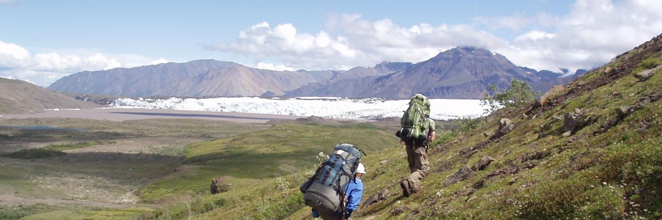
Backpacking in Wrangell-St Elias
A backpacking trip in Wrangell-St. Elias National Park and Preserve can be an exciting and rewarding experience if you are prepared for the difficulties of traveling through rugged, undeveloped land. Help us keep you safe on your adventure by reading the park's backcountry safety page. Do note that proper food storage is required! Bear Resistant Food Containers are available from all park visitor centers.
Trip Planning
For many backpackers, hiring the services of a local guide will make the trip safer and more enjoyable. In general, the areas above tree line (~3,000') afford the easiest hiking and best views. These areas are often accessed by chartering a flight to one of the many possible "bush" landing strips. Note that there are many more places to land than are shown on maps.
Walking across the spruce muskeg with a pack or crossing rivers can take much more time than expected. From a distance the landscape may look like easy hiking, but place a foot in it and you quickly find out the land tests your endurance. While planning your trips, remember that there are very few actual "trails" like you may find in other national parks in the lower 48. Here you will find rugged, un-maintained routes over which you may only be able to travel a few miles in a day. Your party will need to be experienced in reading and following a map and compass. Self-rescue skills are imperative as help is not readily available. For information about permits, dogs in the backcountry, cabins, and much more, check out our Backcountry Frequently Asked Questions page.
You may contact the Copper Center Visitor Center for trip-planning assistance. However, we are not able to recommend multi-day backpacking routes to you. It is your responsibility to research possible routes, and we will gladly answer questions and provide any assistance that we can. We strongly recommend researching routes in hiking books BEFORE contacting us. Here are some suggestions:
- Hiking Alaska's Wrangell-St. Elias National Park & Preserve: From Day Hikes to Backcountry Treks by Greg Fensterman
- Hiking in Wrangell-St. Elias National Park by Danny W. Kost
- Hiking Alaska by Dean Littlepage
- 55 Ways to the Wilderness in Southcentral Alaska by Helen D. Nienhueser
Backcountry Routes
There are countless backpacking trips that can be done in Wrangell-St. Elias. Most of the routes listed here are generally "known" and can be found in hiking books and in magazine articles. Other routes can be found through local guide services and air taxis. There are no maintained or marked routes in the park.
Backpacking Routes Near the Kennecott District:
Dixie Pass Trail (pdf format 928 KB)
Hike along a creek to a high alpine pass. Takes 2-3 days to go to the pass and back. Trail is accessible from the McCarthy Rd.
Nugget Creek Trail (pdf format 1 MB)
15 miles to a cabin, mine, and glacier. Takes 2-3 days to go to the cabin and back. Accessible from the McCarthy Rd. The cabin is very rustic and is available by reservation.
The Goat Trail
Route across Skolai Pass to Glacier Creek. Fly-in destination. No trails to follow. Requires extensive trip-planning. The Glacier Creek cabin can be used on a first come, first served basis.
Erie Mine
Extremely strenuous scramble up the hillside to history. Accessible from Kennecott. No trails to follow. Requires extensive trip-planning.
Donoho Basin
Hike over the glacier to a series of lakes and scenic vistas. Accessible from Kennecott. No trails to follow. Requires extensive trip-planning.
Hidden Creek Valley
Hiking route or fly-in destination. No trails to follow. Requires extensive trip-planning.
Nicolai Pass
4-5 day backpack from McCarthy. No trails to follow. Requires extensive trip-planning.
Backcountry Routes Near the Nabesna District:
Soda Lake Trail (pdf format 494 KB)
Travel the tundra to a remote lake. Takes 2-3 days to hike to the lake and back. Accessible from the Nabesna Rd.
Trail Creek-Lost Creek Loop (pdf format 953 KB)
A spectacular 3-4 day loop. Requires route-finding. Accessible from the Nabesna Rd.
Beaver Creek Area
20 miles of adventure! Fly-in only. No trails to follow. Requires extensive trip-planning.
Chelle Lake Area
A great base camp for exploration, fly-in only. No trails to follow. Requires extensive trip-planning.
Sanford - Dadina Plateau
Wild & remote route, fly-in only. No trails to follow. Requires extensive trip-planning.
Baultoff Creek Area
Explore a remote valley, fly-in only. No trails to follow. Requires extensive trip-planning.
For information to plan a backpacking trip, please email a backcountry ranger at wrst_backcountry@nps.gov
Details
Activity
Backcountry Hiking
For many backpackers, hiring the services of a local guide will make the trip safer and more enjoyable. In general, the areas above tree line (~3,000') afford the easiest hiking and best views. These areas are often accessed by chartering a flight to one of the many possible "bush" landing strips. Note that there are many more places to land than are shown on maps.
Walking across the spruce muskeg with a pack or crossing rivers can take much more time than expected. From a distance the landscape may look like easy hiking, but place a foot in it and you quickly find out the land tests your endurance. While planning your trips, remember that there are very few actual "trails" like you may find in other national parks in the lower 48. Here you will find rugged, un-maintained routes over which you may only be able to travel a few miles in a day. Your party will need to be experienced in reading and following a map and compass. Self-rescue skills are imperative as help is not readily available. For information about permits, dogs in the backcountry, cabins, and much more, check out our Backcountry Frequently Asked Questions page.
You may contact the Copper Center Visitor Center for trip-planning assistance. However, we are not able to recommend multi-day backpacking routes to you. It is your responsibility to research possible routes, and we will gladly answer questions and provide any assistance that we can. We strongly recommend researching routes in hiking books BEFORE contacting us. Here are some suggestions:
- Hiking Alaska's Wrangell-St. Elias National Park & Preserve: From Day Hikes to Backcountry Treks by Greg Fensterman
- Hiking in Wrangell-St. Elias National Park by Danny W. Kost
- Hiking Alaska by Dean Littlepage
- 55 Ways to the Wilderness in Southcentral Alaska by Helen D. Nienhueser
Pets Allowed
Yes
Activity Fee
No
Entrance fees may apply, see Fees & Passes information.
Reservations
No
Season
Year Round
Time of Day
Day
Accessibility Information
Backpacking in the park and hiking on the trails is accessible by foot. However, there is the paved trail on the Bluff Overlook at the visitor center in Copper Center which is wheelchair accessible. It is located about 100 yards (100 meters) from the visitor center and parking area with interpretive waysides and views of the Wrangell Mountains (weather permitting).