Introduction

Modified from “Parks and Plates: The Geology of our National Parks, Monuments and Seashores,” by Robert J. Lillie, New York, W. W. Norton and Company, 298 pp., 2005, www.amazon.com/dp/0134905172.
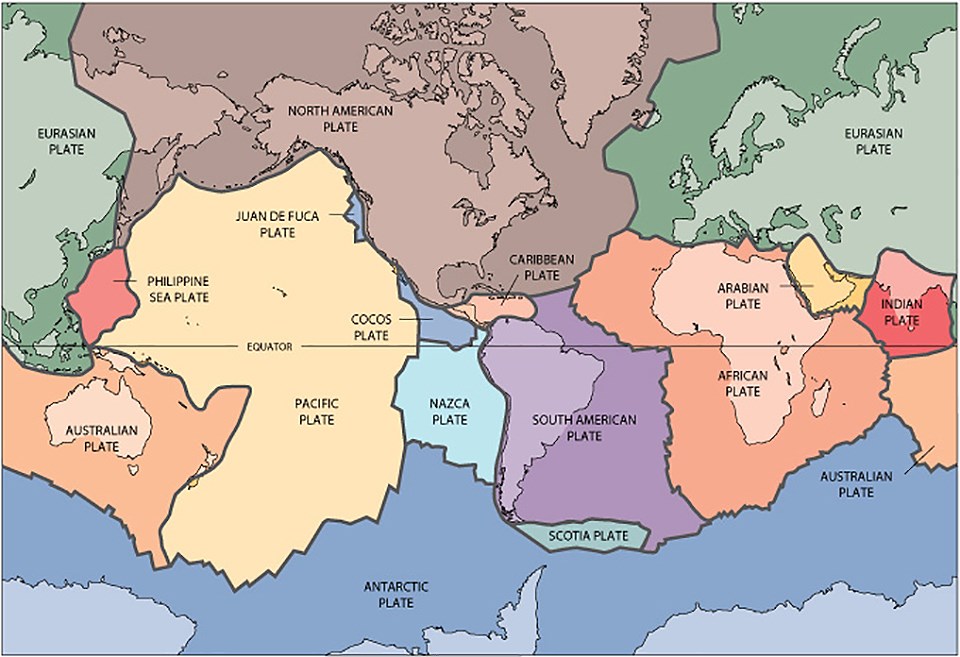
Although the Earth may seem to have a solid outside, its exterior layer (the crust) is actually broken into a number of tectonic plates, each moving very slowly in response to movement of the slowly flowing mantle beneath. Earth’s continents and oceans are shaped by the movements of these tectonic plates. Sometimes they collide. When this happens, their edges are thrust up into mountains if neither plate is denser than the other, while if the plates have different densities, the denser plate sinks under the less dense plate and melts, causing magma to rise up and form volcanos. Sometimes two plates separate, and volcanos occur at the gap, like at the mid-ocean ridges beneath the sea. Finally, in other cases plates slide next to each other; if the plates catch, earthquakes occur.
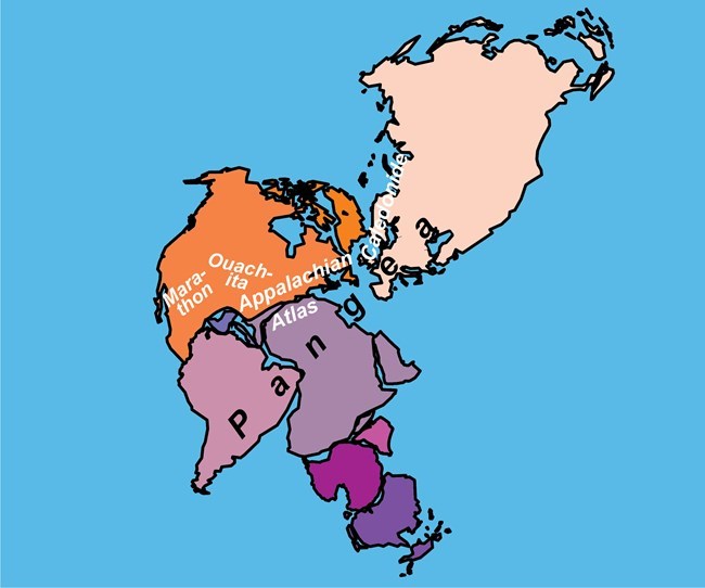
Before the Triassic began, approximately 252 million years ago, the plates had moved in such a way that all of the major landmasses had collided with each other, forming a supercontinent which is called Pangea. This had taken hundreds of millions of years as one continent after another was collected in the whole. You can get an idea of the shape of the core of Pangea by looking at the east coasts of North and South America and the west coast of Africa: when these continents were part of Pangea, these coasts fit together approximately. Antarctica was connected to southeast Africa, and southern Australia to Antarctica, with India (a separate continental block from the rest of Asia) and Madagascar between east Africa, Antarctica, and west Australia. Southwest Europe was wedged between northeast North America and northwest Africa, with much of the rest of Eurasia extending off to the northeast.
Rugged mountain ranges similar to the Himalayas formed along the boundaries; one of these is the Appalachians, now much lower thanks to 250 million years of erosion. The combination of huge internal mountain ranges and vast unbroken expanses of land and sea led to much different climates compared to today. There were great interior deserts and more extreme temperatures from the poles to the equator. Animals could walk from one end of Pangea to the other, but much of it would have been harsh to live in. The formation of Pangea is also thought to have contributed to marine extinctions during the preceding Permian Period by the reduction of shallow marine shelf environments, where much marine diversity is concentrated.

USGS illustration.
Supercontinents don’t last forever. While it is not understood completely why they break up, we can guess that it has to do with the uneven distribution of different kinds of crust. Pangea began to break up toward the end of the Triassic, first along the boundary between North America and Africa. The original continental boundary wasn’t exactly reproduced; instead, North America gained a chunk of land that today includes Florida and nearby parts of the southeastern United States. As the two continents began to move in different directions, long narrow rift valleys formed along the seam. Today something similar is happening in east Africa, and is responsible for the Great Lakes of this region. Like the African Great Lakes, the eastern margin of North America in the Late Triassic featured a number of long, linear lakes and basins, from Nova Scotia to South Carolina. At the very end of the Triassic, approximately 201 million years ago, huge amounts of lava erupted over a short time along the boundary from southwest Europe to northeast South America as what is now the North Atlantic began to open. The breakup of Pangea was in full swing, but would not be complete until much later.
Rocks deposited in the rift basins in eastern North America are classified in the Newark Supergroup. They have produced footprints, bones, and other fossils of the organisms that lived here during the transition from the Triassic to the Jurassic, including plants, freshwater invertebrates, crocodile relatives, and early dinosaurs and their cousins. Because some of these rocks are found in New England and the Mid-Atlantic states, their fossils were among the first studied in North America. Edward Hitchcock pioneered the study of the tracks in the mid-19th century, and both of the leading figures of the “Bone Wars”, Edward Drinker Cope and Othniel Charles Marsh, described fossils from these rocks, practically their back yards. Dinosaur State Park and Arboretum (a National Natural Landmark) in Connecticut preserves tracks from one of these rift basins. To the north in Massachusetts, Springfield Armory (now Springfield Armory National Historic Site) was the site of one of the best early dinosaur discoveries in the world, a partial skeleton of a sauropod cousin now named Anchisaurus. It was discovered during blasting for construction in 1855.
Site Index and Credits
Age of Dinosaurs (2021)
Text by Justin Tweet (AGI). Contributors: Vincent Santucci (GRD), Adam Marsh (PEFO), ReBecca Hunt-Foster (DINO), Don Corrick (BIBE). Project Lead / Web Development, Jim Wood (GRD).
References
-
Tweet, J.S. and V.L. Santucci. 2018. An Inventory of Non-Avian Dinosaurs from National Park Service Areas. in Lucas, S.G. and Sullivan, R.M., (eds.), Fossil Record 6. New Mexico Museum of Natural History and Science Bulletin 79: 703-730. https://irma.nps.gov/DataStore/Reference/Profile/2257153
-
Santucci, V.L., A. Marsh, W. Parker, D. Chure, and D. Corrick, 2018. “Age of Reptiles”: Uncovering the Mesozoic Fossil Record in three Intermountain national parks. IMR Crossroads. Spring 2018, p. 4-11. https://irma.nps.gov/DataStore/Reference/Profile/2253529
Last updated: July 8, 2022
