Last updated: January 17, 2023
Place
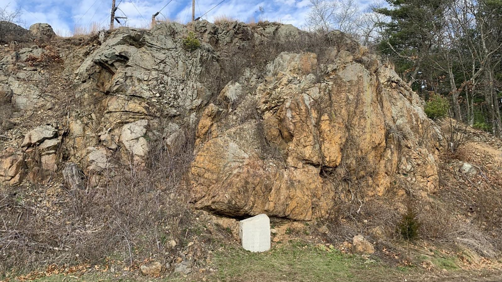
The "Bloody" Bluff
NPS Photo
Quick Facts
Location:
42.447506, -71.265092
Significance:
The Bluff is a sharp outcrop of rocks created by dramatic geological forces millions of years ago. On April 19, 1775 British soldiers fought a short rearguard action from this high, wooded overlook during their retreat to Boston. Today the bluff is a prominent geological and historical feature in Minute Man National Historical Park.
Designation:
Battle Site
Amenities
2 listed
Historical/Interpretive Information/Exhibits, Pets Allowed
The Bloody Bluff battle site in Minute Man National Historical Park is a story 600 million years in the making and demonstrates the awesome power of continental collision.
The story of the bluff began 600 million years ago, when there were only two large continents on earth: Gondwana (made up of Africa, Australia, Antarctica, India and South America) and Laurasia (made up of North America, Eurasia and Greenland). Around that time, two volcanic chains formed off the north coast of ancient Gondwana. Within these volcanic chains were distinct magma chambers, deep below the earth’s surface.
When this magma solidified it formed vast stretches of underground rock at the heart of the two island chains; the older Avalon terrane, and the younger Nashoba terrane. Eventually the younger Nashoba terrane separated from the continent of Gondwana and moved towards the continent of Laurasia, the ancient North American coast. When the Nashoba terrane collided, it sutured with ancient North America. About 20 million years later, the Avalon terrane also followed suit and collided with the Nashoba Terrane rocks. This caused the continent to grow larger, and mountains to rise. This is a process called terrane accretion, where island terranes smash into the edge of continents.
The “Bloody Bluff,” a rock outcrop within Minute Man NHP shows the contact point between the Nashoba terrane and the Avalon terrane—the point where two worlds collided millions of years ago. By examining evidence such as this outcrop, scientists can reconstruct ancient conditions of the landscape. It is now thought that at one point the crust was nine miles thicker than it is today—meaning that there were once grand mountains within the park long ago.
The Bluff has historical significance starting much earlier than April 19, 1775. Human inhabitation of this region dates back over twelve thousand years and by the early seventeenth century Algonquian people had been living along the Musketequid River (Concord River) for about a thousand years. Before contact with Europeans these indigenous peoples hunted large game in the surrounding forests including those that covered the modern-day bluff.
When puritan families ventured inland around 1635, they claimed the prosperous land along the Musketequid River as their own. In a short time, Europeans cleared large tracts of forest to establish Concord Plantation, now Concord, Massachusetts. In the area of the Bluff, the colonists worked to replace forests with farm fields and animal pastures. While most rocky outcrops became farm walls, the scale of the bluff hindered any significant restructuring during the early colonial period.
By the mid-18th century the bluff was likely a wooded outcrop owned by the Whittemore family. While the steep cliff face posed a challenge for agricultural endeavors, the Whittemore’s allowed the striking hilltop to grow a thick coverage of trees. During the early colonial period, the local community constructed a road running through the region and took special care to wrap it around the base of the bluff as opposed to going over it. Eventually the road to Concord Plantation became the Bay Road
On the morning of April 19, 1775, seven-hundred British soldiers passed the bluff on their march to raid military stockpiles in Concord. Later that day the same British column, excluding scores of casualties, fought a short rear-guard action on the bluff to cover their hasty retreat to Boston.
After rushing through a hail of musketry along the Bay Road, the weary British soldiers crossed a small bridge near the home of Tabitha Nelson; six hundred yards west of the bluff. In the blink of an eye concealed militia from Captain Parker’s Lexington company poured a heavy volley into the British ranks before retiring to better ground. When flanking companies of British light infantry engaged Parker’s men at the small wooded rise, the lead elements of the British column continued down the road and passed the Whittemore Farm.
With over a thousand Colonial militia quickly closing on the column, the British rear-guard passed the Whittemore house and the Bull Tavern before ascending the sloped sides of the bluff. From this commanding viewpoint covered by trees, the Regulars watched Colonial militia advance to the tavern, a building that Reading militia man Rev. Edmund Foster knew as “Benjamin’s Tavern.” The British rear-guard then opened fire from the high ground at the bluff and covered the lead elements of their column now ascending Fiske hill. Rev. Edmund Foster with the Reading militia near the Tavern recalled, “a man rode up on horse back unarmed. The enemy were then passing round the hill just below the tavern. They had posted a small body of their troops on the north side of the hill, which fired upon us. The horse and his rider fell instantly to the ground; the horse died immediately, but the man received no injury. We were quick at the spot, from which we returned the fire.”
Dramatically outnumbered and outflanked the British detachment atop the bluff withdrew. As the regulars descended the rocky hillside into the low area behind, more colonial militia hidden behind trees, rocks and fence rails on Fiske Hill opened fire. Desperately attempting to protect the column and cover the retreat, a mounted British officer galloped to the front. Edmund Foster continued, “An officer, mounted on an elegant horse, and with drawn sword in his hand, was riding backwards and forwards, commanding and urging on the British troops. A number of Americans behind a pile of rails, raised their guns and fired with deadly effect. The officer fell, and the horse took fright, leaped the wall, and ran directly towards those who had killed his rider. The enemy discharged their musketry in that direction, but their fire took no effect.”
Colonial militia quickly stripped the horse of the officers effects, finding a beautiful brace of engraved pistols. At the time, the militia claimed their prize belonged to Col. Pitcairn commanding the detachment of British Marines, however recent scholarship indicates the pistols instead belonged to another British officer, Captain William Crosbie of the 38th Regiment’s grenadier company, wounded on April 19, 1775.
After abandoning their position near the bluff and descending into the low ground before Fiske Hill the British rear-guard ran a gauntlet of “plaguy fire,” from the concealed militia. In this area, Concord Historian Frank Coburn stated, “many British were wounded, and many killed, along this part of Battle Road.” At some point between Parker’s Revenge and Lexington, colonial militia also wounded Lt. Col Smith, commanding the entire British column. Exhausted from continuous skirmishing and missing numerous officers, the British ranks quickly devolved into a general route one mile from Lexington center. Fortunately for the exhausted British soldiers, a relief column of 1000 reinforcements and two artillery pieces arrived in Lexington.
When the fighting passed from the bluff and Fiske Hill, the injured lay scattered through the fields and homes all around. In the area of the bluff, historians recorded the burial of at least two British soldiers.. The fighting in this area had been short yet fierce.
During the 19th and 20th centuries the bluff and surrounding landscape underwent many changes. In the New Republic era additional farmhouses dotted the landscape and new businesses appeared driving up local travel. In 1802 and 1806 portions of the Battle Road were straightened and some new segments by-passed historic sites. In the area of the bluff, a newly constructed road by-passed areas such as the Nelson farms and accommodated increased traffic. Directly at the base of the bluff the new road intersected with the historic Bay Road, now called Massachusetts avenue. In addition, the landscape evolved when a larger tavern replaced the historic Bull’s Tavern. Construction workers also quarried rocks from the hillside east of the bluff throughout the 19th century for various projects. Although altered, the bluff remained a source of local legend concerning April 19, 1775. In 1885 residents erected a small monument at the base of the bluff to commemorate the revolutionary history of the site.
In the century following, construction work continuously cut into the historic cliff face. In 1938, workers even blasted into the rock to widen the road for automobiles, altering the bluff’s appearance dramatically. In the later 20th century, a corridor of power lines arced over the bluff, dramatically altering the battlefield viewshed yet again.
In the century following, construction work continuously cut into the historic cliff face. In 1938, workers even blasted into the rock to widen the road for automobiles, altering the bluff’s appearance dramatically. In the later 20th century, a corridor of power lines arced over the bluff, dramatically altering the battlefield viewshed yet again.
On September 21, 1959, Public Law 86-321 established Minute Man National Historical Park, incorporating the area surrounding the bluff. The mission of the new park was to “approximate the cultural environment that existed in 1775 and preserve and interpret individual resources that contribute to understanding the events of the Battle of Lexington and Concord.” As part of this preservation and interpretation initiative, the National Park Service constructed a Visitors Center a short distance west of the bluff and reestablished pedestrian walking spaces throughout the area. In 1996 the Battle Road Trail connected major historical sections of the park following the original bay road. Today, the National Park Service preserves and interprets the bluff as a core historic site within Minute Man National Historical Park.
Coburn, Frank Warren, 1853-1923. The Battle of April 19, 1775: In Lexington, Concord, Lincoln, Arlington, Cambridge, Somerville, And Charlestown, Massachusetts. 2d ed., rev. and with additions. Lexington, Mass.: The Lexington historical society, 1922.
Dietrich-Smith D. 2005. Battle Road Unit: Cultural Landscape Report, Minute Man National Historical Park, National Park Service. Cultural Landscape Report. National Park Service, Northeast Regional Office; Olmsted Center for Landscape Preservation. Northeast Regional Office
Douglas Sabin, April 19, 1775: A Historiographical Study, (Minute Man National Historical Park, Concord, 1987).
Kehoe, Vincent J-R. 1974. "We were there!": April 19th 1775. [Chelmsford, Mass.]: [The author].
NPS Northeast Regional Office. 2012. Nelson Farm Area: Cultural Landscape Inventory, Minute Man National Historical Park, National Park Service. Cultural Landscapes Inventory reports. 650043. Northeast Regional Office/ CLI Database
Rev. Edmund Foster quoted in Rev. Ezra Ripley, A History of the Fight at Concord, (Allen and Atwell, Concord, 1827), 32-33.