Last updated: January 26, 2023
Place
Split Rock

Historical/Interpretive Information/Exhibits, Restroom, Scenic View/Photo Spot, Trailhead, Wheelchair Accessible
A map of Passport and Places to Go locations for National Historic Trails.
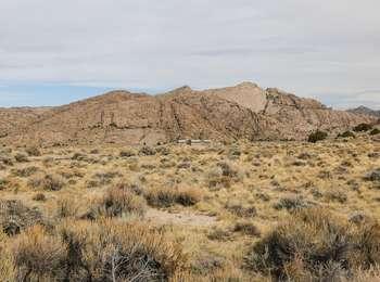
Split Rock is a "gun sight" notched landform that rises 1000 feet above the sagebrush plains. It was visible to emigrants for two days or more as they approached, and then, left it behind. Some of the emigrants found the landform to be a useful navigational tool, since it guided them directly to South Pass. The Bureau of Land Management has developed an interpretive site on the south side of Split Rock. A short hiking trail, with interpretive panels regarding the area and its history, leads to an overlook of Split Rock. A second highway turn-out a few miles west offers a good (although reversed) view of the "split" in the rock.
Emigrant Remarks
"[Y]esterday," Joseph Middleton wrote in 1849, "from the time we started we steered to this cliff with a steadiness that was astonishing, never deviating from it more than the needle does from the north pole, excepting once for a short time-I think this cleft or rent or chasm is very conspicuously seen from the Devil's Gate, which I think is 11 miles from here; and I think it is still at least 6 or 8 miles ahead. ..."
Site Information
Location (east of Jeffrey City, Wyoming)
