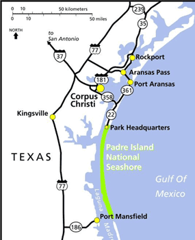
NPS map Of the National Seashore’s four sides, three border on water. The eastern shore has 65.5 miles of Gulf shoreline comprising sand and shell beaches, all of which are open to the public. The southern boundary is a manmade channel known as the Mansfield Channel. This 300-foot wide channel was created in 1957 and is used by shrimp boats and recreational boaters. The western shore borders the Laguna Madre, which is a shallow, hypersaline lagoon 1.5 to 3 times as salty as the ocean and is composed of extensive mudflats, which are considered environmentally sensitive. There are only two locations within the park for the general public to access the Laguna Madre: at Bird Island Basin and at Yarborough Pass. Camping along the Laguna Shore outside of these areas is not allowed and hiking along the Laguna Shore outside of them is strongly discouraged because of the shoreline’s environmental sensitivity. Because there is little flow of sediments along the Laguna shore, damage to the mudflats can last a long time. Tire tracks and footprints left over twenty years ago can still be seen in some parts. |
Last updated: February 18, 2025
