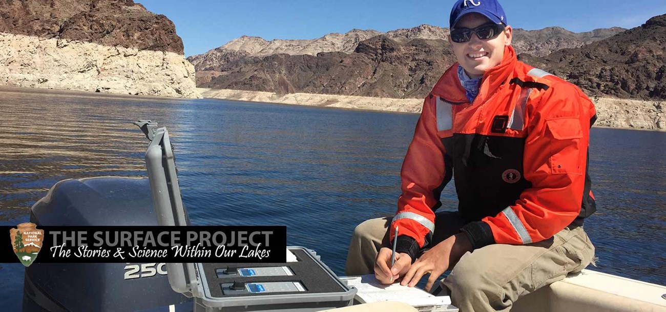
Testing the WatersLakes Mead and Mohave serve as learning labs where exciting research happens every day. Federal, state, and local agencies and universities work together on a continual basis to monitor and assess water quality and the health of lake ecosystems. This includes everything from microscopic biological processes, to water chemistry, to big questions about how lowering lake levels are affecting lake health. Just like you may undergo blood tests with your doctor to provide a health checkup, there are a number of accepted indicators that scientists monitor to provide a “checkup” of lake ecosystem health. These include water temperature, dissolved oxygen, pH, conductivity, turbidity, chlorophyll a (a surrogate for lake productivity (algal growth), and plankton. These measurments enable scientists to assess overall water quality and lake health for both lakes Mead1 and Mohave2. 1 The Limnology of Lake Mead, 2011 Report of Findings (PDF - 1.2 MB) 2 Initial Assessments of Lake Mohave Water Quality (PDF- 2 MB) The National Park Service, Southern Nevada Water Authority, Bureau of Reclamation, City of Las Vegas and City of Henderson cooperate to collect health indicator samples monthly at some 22 sites on Lake Mead and six sites across Lake Mohave. The agencies frequently work together to evaluate water monitoring data and lake ecosystem conditions, as found for example in the comprehensive interagency study published by USGS in 2012. The USGS maintains stations on lakes Mead and Mohave for monitoring water quality and determining evaporation rates for the lakes. The agencies meet throughout the year to discuss findings, threats to lake health, and needed monitoring. They also jointly sponsor a Lake Mead science symposium every other year. 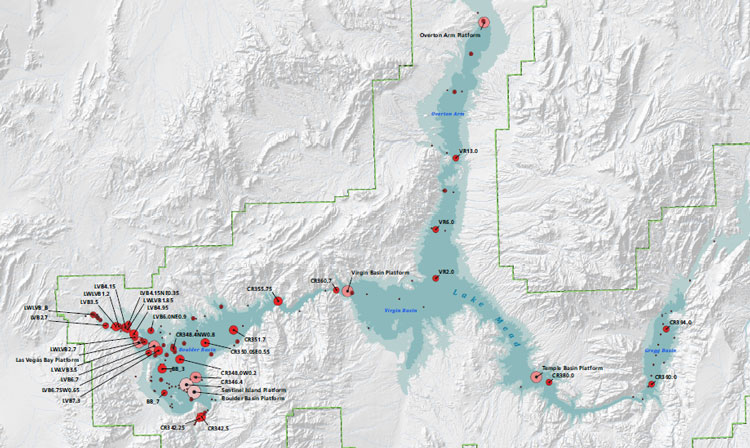
Water Mixing and HydrologyOver time the lake health indicator information can be used chart the way that the water within lakes Mead and Mohave moves and mixes. The Colorado River, Virgin River, Muddy River and Las Vegas Wash each have their own identifying water characteristics, such as temperature and conductivity, which can be used to track the flows of the individual tributary source waters as they spread across the lake. This provides an understanding of how the lake functions. The water mixing and hydrology within the lakes determines the distribution of nutrients and contaminants. Nutrients that arrive within warm water flows may stay on the lake surface to produce algae; nutrients that arrive in colder water sink to the bottom away from the algae production zone. The distribution of the source flows (based upon temperatures), dissolved solids within the water, and weather (wind speed and direction), determines the transport of nutrients and contaminants. This in turn drives food availability, food web dynamics, the accumulation of contaminants, and densities of fish and wildlife around the lakes. 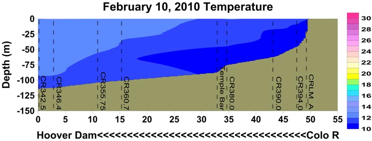
In this graph of water temperatures, the darker blue (colder) water entering from the Colorado River on the right is shown to sink and flow as an undercurrent all the way to the Hoover Dam. Chart courtesy of SNWA. 
In this graph the colder and saltier waters from a December 2010 flood event on the Virgin River were shown to have settled near the Hoover Dam. Monitoring one month later (graph below) showed the clearing of the Virgin River flood waters by action of the Colorado River inflow. Chart courtesy of SNWA. 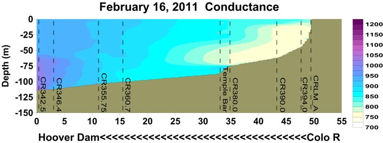 Mixing patterns are impacted by the warmer water temperatures and lower lake levels due to drought and climate change. Understanding how the lake waters mix, and how climate may alter future mixing, is critical for planning for future conditions. From 2004 to 2009 data was collected to give a complete picture of how water mixed within Lake Mead under varying conditions of season of year, weather and lake levels. Data collected included wave and wind patterns, water quality, and lake bottom contour (or lake depth) maps. With that information scientists were able to construct and test a lake-wide three dimensional water quality model3 for Lake Mead. The model provides a management tool that can track water quality indicators throughout the lake and predict water quality conditions under various scenarios of lake level changes, or tributary water quality changes. The model has been used for a number of planning studies4 related to declining lake levels and water quality, including helping to determine the best location for the new Southern Nevada Water Authority drinking water intake. 3 Whole Lake Mead ELCOM-CAEDYM Model, 2006-2007 4 Climate Change Modeling in Lake Mead 
3D water quality model is based on tracing water quality measures moving within a 300 meter grid pattern across Lake Mead. Graphic courtesy of Flow Science. Lake Mead NRA and the National Weather Service (NWS) have developed a weather observation system for both lakes. This system5 includes 12 land based weather stations situated around both lakes, and three buoys in Lake Mead and two buoys in Lake Mohave. The land based stations record wind, temperature, humidity, and atmospheric pressure. The buoys record wind speed and direction, wave heights and direction, air temperature, water temperature, humidity and atmospheric pressure. The data is communicated on a real-time basis via satellite and greatly enhances development of localized weather forecasts, small craft advisories, and special marine warnings. The goal is to use this information in the future to include lakes Mead and Mohave in the NWS nationwide Nearshore Wave Prediction System, a wave model6 used across the country to enhance predictions for wave heights and water levels (swells) to warn boaters and lake users of impending signfiicant weather events. 5 National Weather Service Overview and Briefing on the Lakes Mead and Mohave Project (PDF-3.2 MB) 6 National Weather Service Wave and Wind Modeling Efforts Over Lake Mead and Lake Mohave Recreational Water QualityDue to growing concerns that changing conditions related to lower lake elevations may increase the potential for harmful algal blooms or pathogens in popular shallow water swim areas, Lake Mead National Recreation Area has developed a monitoring and management response guide7 to ensure the protection of swimmers. The Lake Mead NRA Recreation Suitability Guidelines incorporates recommendations and standards from the U.S. Environmental Protection Agency, the World Health Organization, and the Nevada Department of Environmental Protection to ensure that Lake Mead and Lake Mohave provide water that protects the health of the recreating public while also providing a high quality setting for the public to enjoy. 7 Lake Mead NRA Recreation Suitability: Guidelines for Water‐Based Recreation 
The Lake Mead NRA Recreation Suitability Guidelines ensure that waters meet high recreation suitability standards. The guidelines established three main water parameters for routine monitoring to ensure that waters meet high recreation suitability standards. These are human pathogen indicator bacteria8, abundance of the algae species with potential to generate algal toxins (and presence of any algal toxins), and chlorophyll as the commonly used indicator of overall algae productivity. Scientists have analyzed over fifteen years of data from lakes Mead and Mohave relative to parameters for the assessment of recreation suitability and found the lakes score well within the good, or healthy, category. By the standard measures used to provide lake health checkups, lakes Mead and Mohave were found to provide outstanding9 water quality. Lake Mead NRA continues to monitor recreation suitability indicators weekly between mid-May through mid-September in high use recreation areas and has procedures in place to notify the public should any problems be found. 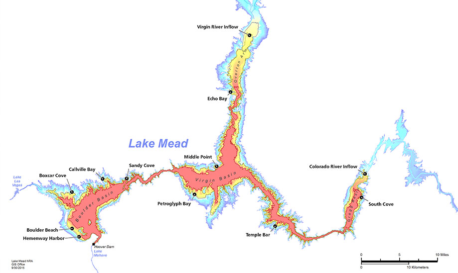
Lake Mead NRA has many bacteria monitoring locations to ensure safe water quality conditions. 8 USGS 1381 Circular: Human Health, Pathogens, and Suitability for Recreation (Pg.126) Contaminants MonitoringThe greatest source of contaminants into Lake Mead is the Las Vegas Wash10 which delivers the surface runoff of Las Vegas Valley as well as treated wastewater effluent to the Boulder Basin. Major types of contaminants found in the wash include inorganic chemicals such as selenium and perchlorate, organic chemicals once previously manufactured in Las Vegas Valley such as DDT, currently used organic chemicals such as pesticides and oils that drain off of surfaces into the Las Vegas Wash, and a suite of chemicals referred to as emerging contaminants of concern. These include residual personal care products and medicines that are not removed by the wastewater treatment processes as well as chemicals known as endocrine disruptors. There have been numerous monitoring programs and research studies evaluating the amounts of these compounds in the water in Lake Mead and the sediments deposited as Las Vegas Wash enters the lake. Endocrine disrupting compounds (EDCs) are chemicals that may interfere with the body’s endocrine system with the potential to produce adverse developmental, reproductive, neurological, and immune effects in both humans and wildlife. A wide range of substances, both natural and man-made, are thought to cause endocrine disruption, including pharmaceuticals, dioxin and dioxin-like compounds, polychlorinated biphenyls, DDT and other pesticides, and plasticizers such as bisphenol A. Endocrine disruptors may be found in many everyday products – including plastic bottles, metal food cans, detergents, flame retardants, food, toys, cosmetics, and pesticides. 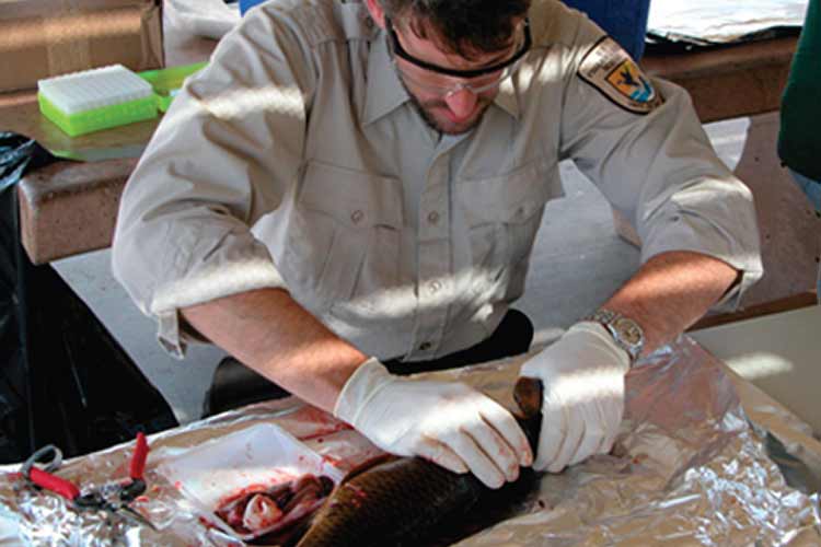
USFWS biologist preparing carp for EDC analysis. From the extensive contaminants monitoring at Lake Mead11, levels of EDCs do not appear to be at concentrations known to cause signficant human health issues. Studies have shown that fish, with their constant exposure to the aquatic environment, do exhibit biomarkers or physical effects from contaminants principally believed to be from endocrine disruptors. The extent of these effects noted to individual fish on the overall fish population are not yet known. Lake Mead has been extensively studied for contaminants and has played a role in national understanding12 of the effect of some of these contaminants on fish. 11 Occurrence of Organic Contaminants in the Lake Mead Region from 2002 to 2014 Fish and Wildlife MonitoringSport FishRecreational sport fishing is an important activity for lakes Mead and Mohave. To assess the health and trends of populations of sport fish and their food sources, the Nevada Division of Wildlife and the Arizona Game and Fish Department, with assistance from other agencies on the lakes, take the lead in annual sport fish monitoring13. This consists of annual sport fish surveys on both lakes, conducted through assessing catch rates in nets set on established transects14 across the lakes, as well as monitoring through electrofishing in standard areas. The agencies also utilize similar methods to assess the abundance of various forage fish15 or primary production fish such as threadfin shad that provide food for the larger sport fish. 13 Lake Mead Sport Fish - Razorback Sucker Workgroup Meeting 14 Lake Mead Sport Fish Monitoring (PDF-4.6 MB) 15 USGS 1381 Circular: Forage Fish (Pg.81) 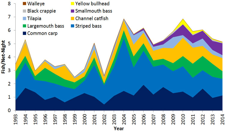
Cumulative gillnetting catch rates of sportfish species in Lake Mead, 1993-2014 (NDOW data), from UNR analysis. 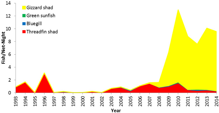
Cumulative gillnetting catch rates of forage fish species in Lake Mead, 1993-2015 (NDOW data), UNR analysis. The agencies also conduct angler surveys to track fishing success rates (species caught per angler hour) as another assessment of condition of the sport fishery. Recent angler catch rates remain comparable with, or in some cases higher than, historical catch rates. Total sport fish catch rates indicate an overall stable population for Lake Mead. Lake Mohave has seen catch rates generally trending upward toward historical averages since 2006 with the highest catch rate recorded in 2015, suggesting a stabilizing sport fishery. Overall monitoring suggests that recreational harvesting is stable and sustained by current sport fish populations. 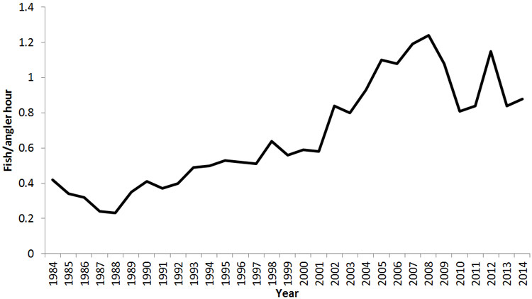
Angler catch rates in Lake Mead collected from creel surveys, 1984-2014, NDOW data, UNR analysis. Aquatic BirdsLakes Mead and Mohave are an important stopover habitat and wintering grounds for many aquatic birds migrating along the Pacific and Intermountain flyways. A comprehensive aquatic bird survey16 conducted year around on both lakes during 2004 through 2009 documented 92 species of aquatic birds using the lakes17. These included the American coot, mallards, western and Clark’s grebes, green-winged teal, common goldeneye, ruddy ducks, common mergansers, double-crested cormorant, American avocet, as well as California and ring-billed gulls. 16 Inventory and Monitoring of Shoreline and Aquatic Bird Species (temporarily unavailable) 17 The Status of Aquatic Associated Birds in LMNRA: 2004-2013 (PDF-2.1 MB) 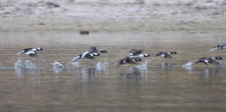 While a number of these birds are year-round residents, abundances of many of these species can vary as populations migrate. In the spring of 2007, for example, over 16,000 eared grebes were noted in one large congregation. Four additional species not generally considered aquatic birds were noted to rely on aquatic prey, including the osprey, the belted kingfisher, the bald eagle, and the peregrine falcon. a) Lake Mead 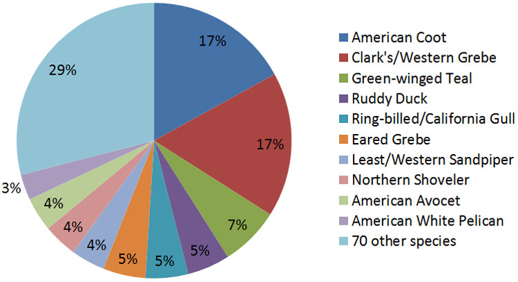 b) Lake Mohave 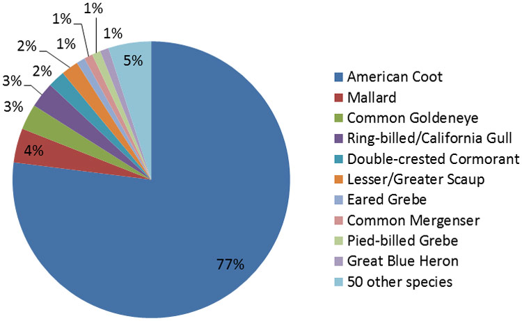 Lakes Mead and Mohave support three aquatically associated raptors, the bald eagle, the osprey, and the peregrine falcon. Osprey feed entirely on fish; bald eagles rely on fish but also prey on aquatic birds and small mammals, as well as scavenge for carrion. Peregrine falcons on the lakes feed on over 29 species of aquatic birds. Annually, Lake Mead NRA conducts a one day wintering bald eagle count, utilizing staff and volunteers to inventory the entire shoreline of both lakes Mead and Mohave. The number of wintering bald eagles documented over the past ten years (2007-2016) has ranged from a low of 97 to a high of 178. Active peregrine falcon nests are monitored annually during the spring nesting season. Peregrines are year-round residents at lakes Mead and Mohave. Documented nests increased from 16 in 2005 to 37 by 2010. 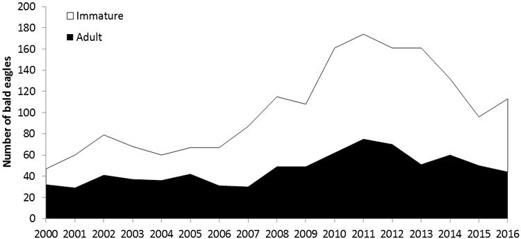
Number of bald eagles recorded from 2000 through 2016 during the winter counts at Lakes Mead and Mohave. Data from Fletcher & Jaeger, 2011 and Lake Mead NRA, personal communication, UNR analysis. 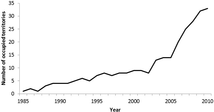
Number of known occupied peregrine falcon territories within Lake Mead NRA from 1985 through 2010. Data from Barnes & Jaeger, 2010 and Barnes et al., 2015, UNR analysis. Native FishNumerous agencies also share resources to conduct annual monitoring of native fish populations on both lakes Mead and Mohave. These activities are coordinated by the Bureau of Reclamation through the Lower Colorado River Multi-Species Conservation Program. The native fish population assessments rely on data from catch rates for standardized placement of gillnets and electrofishing in standardized areas. Razorback sucker populations on Lake Mohave have been closely monitored since the early 1990s. At that time, the population estimate for Lake Mohave exceeded 40,000 adult fish, but they were all older adult fish who had survived since the creation of Lake Mohave in 1951. These adults were spawning in Lake Mohave, but increased predation and the change in environmental conditions prevented the spawning larval fish from becoming reproducing adults18. The population was expected to decline, and likely disappear, without intervention. 18 Summary of Lower Colorado River Native Fishes Database Activities Since the 1990s, the partner agencies have conducted an active program of collecting the spawning juveniles and growing them to adult size in hatcheries and ponds free from predation. These large adults are then returned to Lake Mohave where they have a chance to reproduce. This active management has ensured that Lake Mohave continues to contain the largest remaining population of razorback suckers in the Colorado River Basin. The Lake Mohave populatioin also contains the greatest genetic variation of any razorback sucker population19 on the Colorado River. While the population is not thought to be self-sustaining, it is believed that it can be maintained by the stocking of large fish grown from wild-caught larvae. 19 Demographics and Monitoring of Repatriated Razorback Sucker in Lake Mohave 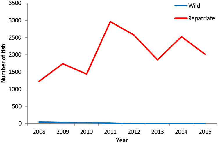
Wild and repatriate razorback sucker population estimates in Lake Mohave based on field data collected in March between 2008 and 2015 by Marsh & Associates (2015), UNR graph. Lake Mead razorback populations experienced significant declines in the 1970s, and surveys in the 1980s did not detect any razorbacks in Lake Mead. Surveys in the early 1990s, however, found low numbers of fish and one spawning bed in the Las Vegas Bay. The Lake Mead razorback sucker population at that time was considered to be low and in danger of being lost. Increased Lake Mead surveys since 2000, however, have found additional spawning locations and increased numbers of fish. Adults are known to spawn in at least four locations20 within present day Lake Mead: the inner Las Vegas Bay on the western end of Boulder Basin, two areas of Overton Arm, and the inflow areas of Gregg Basin where the Colorado River enters Lake Mead from the Grand Canyon. The Lake Mead population is now estimated to contain several hundred individuals. Populations are monitored through gillnet surveys, and studies have been added to track tagged fish to determine habitat and use areas. The fish tracking studies have found Lake Mead razorback suckers also utilizing areas of the lower Grand Canyon. Additional research is planned to determine which conditions facilitate natural recruitment, why the population is increasing, and the long term status and management implications for the overall recovery efforts. 20 USGS 1381 Circular: Species of Special Concern (Pg.84) 21 Longterm Razorback Sucker Monitoring Annual Report (temporarily unavailable) 22 Razorback Sucker Research and Monitoring in the Colorado River Inflow Area AIS Internship Program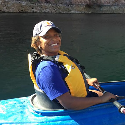 Working collaboratively with Lake Mead National Recreation Area (LMNRA), the Great Basin Institute is recruiting interns to learn about and participate on multiple projects including resource management and education at LMNRA. During the main boating season (May-September), the intern will educate the boating public about aquatic invasive species (AIS) and water safety, as well as gain skills and knowledge of natural and cultural resources in the LMNRA. "As an Aquatic Invasive Species intern at Lake Mead National Recreation Area in 2016, I was fortunate enough to have an unbelievable experience that exceeded my expectations. Not only did this program provide numerous opportunities to gain hands-on experience in various settings and areas of interest, but also a family within the National Park Service. Each coordinator in the AIS program helped me embark on my self-discovery and assisted me in striving to reach my full potential. The program was transformative in many ways, and I was able to take on leadership roles by participating in several workshops and programs for youth organizations and schools. I built relationships with people who became my good friends and my ardent supporters. Because of my experience as an AIS intern, I am now able to step further into my journey with great confidence and support that will last a lifetime." Learn MoreConnected to the River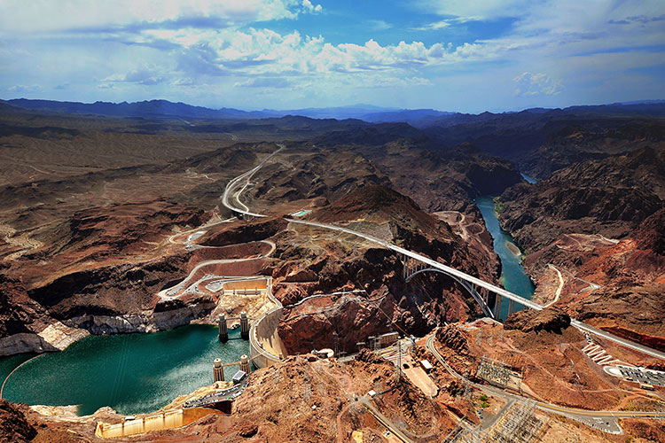
The Colorado River is a vital source of power to many people in the Southwest. The Colorado River means many things to many people: a critical water source, a natural wonder, a region full of cultural significance, and a great place for recreation. It’s also an incredible scientific learning opportunity – a 1,400-mile open air experiment requiring scientists to investigate how to balance the competing water needs for forty million people. This includes everything from microscopic biological processes to big questions like how to ensure future water supplies to meet societal needs in face of a changing climate. |
Last updated: February 1, 2018
