

HAER Fly-through Animation of West Union Bridge, West Union, IN
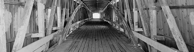
West Union Bridge (HAER IN-105) is the work of the prolific Indiana covered bridge builder Joseph J. Daniels (1826-1916) and is an excellent example of his use and development of the Burr Arch Truss. At 315' from portal to portal, the double-span bridge is the longest covered bridge in Parke County, a county known for its numerous covered bridges of considerable length. J.J Daniels built the bridge in 1876 to replace the previous bridge (also of his design and construction) crossing Sugar Creek, which was destroyed by high water. Daniels built nearly sixty covered bridges in Indiana between 1855 and ca. 1900. The West Union Bridge represents a later Burr Arch Truss design.
The National Covered Bridges Recording Project was undertaken by the Historic American Engineering Record (HAER). It is a long-range initiative to document historically significant engineering and industrial works in the United States. HAER is administered by the Heritage Documentation Programs (Richard O'Connor, Chief), a division of the National Park Service, U.S. Department of the Interior. The Federal Highway Administration's National Historic Covered Bridge Preservation Program funded the project.
The 2013 HAER field team consisted of project leader Christopher H. Marston; HAER architect Jeremy T. Mauro, field supervisor; and Benjamin Shakelton and Hummam Salih, both Catholic University architecture students. The drawings support earlier HAER documentation by historian Lola Bennett and HAER photographer Jet Lowe. The West Union Bridge was documented using high definition surveying (HDS) technology. A Leica ScanStation C10 was used to collect data onsite. The fly-through of the pointcloud was rendered in Pointools. The 3D model was created in AutoCAD using Leica CloudWorx to reference the scan data and later imported into 3dsMax. The topography was generated from scan data gathered in the field and processed using LAStools to remove trees and vegetation. The stone abutments were meshed in Geomagic. The 3D model, abutments, and topography were used to produce archival drawings of the bridge to be included in the HABS/HAER/HALS Collection at the Library of Congress.
Learn More...
- See the documentation of West Union Bridge in the HABS/HAER/HALS Collection at the Library of Congress

