Trailhead directions: this trail can be accessed at three different locations:
1. The (Yellowstone) South Gate Boat Launch and Picnic Area access road, 1.6 miles north of the turn-off to Flagg Ranch.
2. A connector trail from the Polecat Creek Loop (directions for the trailhead are on the Polecat Creek blog post).
3. Across the roadway from a parking area and picnic area next to the Snake River Bridge.
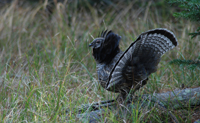
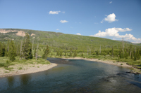
Trail description: The Flagg Canyon Trail follows the canyon rim along the west side of the Snake River. As this trail only gets light to moderate use, quiet hikers may see elk, squirrels, grouse, and otters.
600,000 years ago, a lava eruption made out of rhyolite, a volcanic rock, flowed south from the Yellowstone caldera. Over the course of geologic time, the Snake River has carved a canyon through the now-solidified lava flow.
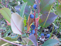
The path parallels the Snake River. As you travel through the lodgepole pine forest, look for plants that thrive in the shade below these trees: Oregon grape, grouse whortleberry, Utah honeysuckle, and wild strawberry. The berry crop supports a variety of bird species, including dusky and ruffed grouse.
Ruffed Grouse - NPS Photo/Danielle Lehle
The trail soon travels away from the river and slightly towards the road, but numerous spur trails give you access to the canyon edge. At 1.3 miles, a signed trail junction connects you to the path leading to the Polecat Loop Trail and the Flagg Ranch parking area. To continue on the Flagg Canyon Trail, go straight. The path now travels through open lodgepole pine forest mixed with grassy meadow areas.
Oregon Grape - NPS Photo
Across the river on the slopes of Huckleberry Mountain, observe the regrowth of trees after the 1988 Huck Fire. This fire started on August 20 when winds over 60 mph blew a tree across a powerline in the parkway. Not until winter snows began was the fire finally declared extinguished.
NPS Photo/D. Lehle
The path descends a small hill and passes a small pond to the right before reaching the bridge over the Snake River, 2.5 miles from the trailhead. Retrace your steps to return to your car.
Trail information : Woods, Rebecca. Jackson Hole Hikes. Jackson: White Willow Publishing, 2009.


