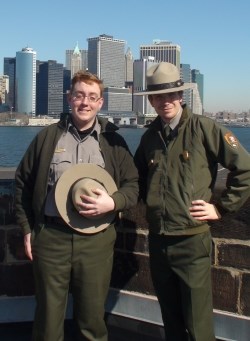
Ilyse Goldman/NPS It's the dawn of a new day for me, if only I knew what day it was... Oh wait, it's... FRIDAY Escape from New York I'm leaving Governors Island National Monument! My seasonal position has come to its end here. In a week's time I'll be working in Yosemite National Park through the summer. But who knows, I may come crawling back at some point. I will certainly miss it here. The Winter season was refreshing. I find it amazing that here, in the most densely populated and largest city in the US, that there is a place as quiet as this. It's ironic considering that I will have to deal with considerably more people, crowds of them, in Yosemite Valley, a place seemingly so far removed from the hustle and bustle of the cities. I will also miss my delightful coworkers. Thanks for all the wonderful opportunities, fun, fun, and thinking about fun. Don't cry for me, Governors Island. I will keep you in my heart always. I will draw inspiration from this place and the people in it when I'm out there interpreting, somewhere, within the vast fabric of the NPS cosmos. 
April 11, 2011 "Nasty Governors Island Water Goes Back a Long Time!" Click here for a video description of the Fort Jay underground rooms with Ranger Adam and Archaeological Consultant Linda.On Monday, March 28 I had the opportunity to observe sidewalk restoration work being done in Fort Jay. Using a small backhoe and shovels, workers were digging in the interior quadrangle of the fort to secure a stable foundation for historically appropriate flagstone walkways. 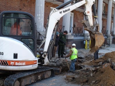
Adam Ramsey/NPS 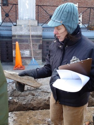
Adam Ramsey/NPS 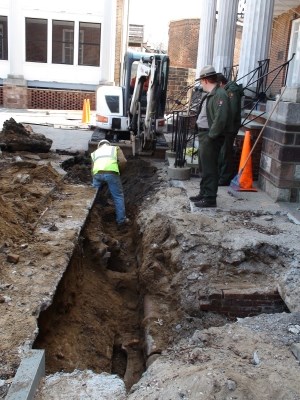
Adam Ramsey/NPS 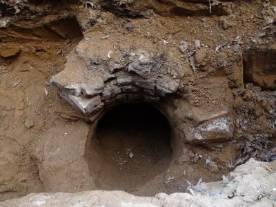
Adam Ramsey/NPS The red brick roof and air-shaft of an underground vault were encountered during digging. Dirt is apparently escaping the trench into the chamber, filling it up and making the foundation work for the new sidewalk very difficult for the contractors. 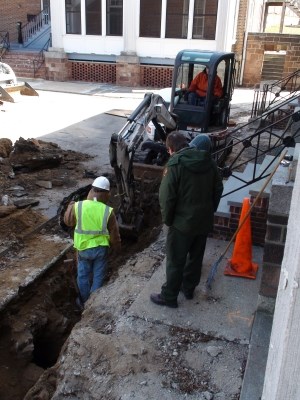
Adam Ramsey/NPS 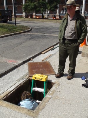
Adam Ramsey/NPS 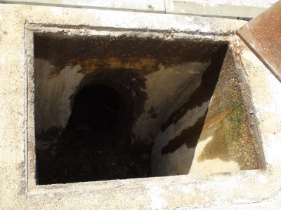
Adam Ramsey/NPS 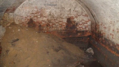
Adam Ramsey/NPS 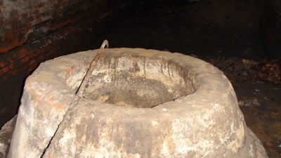
Adam Ramsey/NPS 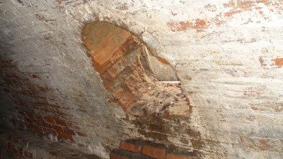
Adam Ramsey/NPS By the following decade, the vaults had been completely forgotten about. According to John Grube, maintenance foreman with the post engineers working during the 1940s, a mosquito problem arose in Fort Jay. The workers were apparently oblivious to the existance of the underground chambers, but they assumed there to be standing water somewhere underground to allow for the breeding of mosquitoes. They began drilling exploratory holes through the soil, looking for a void under the courtyard. When their drills penetrated one of the chambers, they fumigated it with DDT to prevent further mosquito breeding. Mosquitoes in Fort Jay have long been problematic. Throughout the 1800s, outbreaks of a disease thought to be cholera among workers and troops was a common occurrence. It is likely that the affliction plaguing Governors Island was actually Yellow Fever, which is spread by mosquitoes. There is documentary evidence suggesting the chambers under the courtyard of Fort Jay were the source of some of the disease carrying mosquitoes. In 1868, a gentleman known as Surgeon Page described the "cisterns" under the courtyard as having run dry, but the stair cases leading into them were still open. Page mentioned that when they dried out, they were cleaned and fumigated, likely to prevent the breeding of mosquitoes and disease in the future. The 1868 reference by Surgeon Page is the first explicit reference to the subterranean courtyard "cisterns" that I have been able to turn up. All previous documents describing the architectural features and renovations before that time are vague about water sources. Many of the historic documents about Fort Jay mention other cisterns built under the ramparts between the scarp, or fort wall, and the barracks buildings. Four, maybe eight of these vessels were constructed during the 1830s renovation of Fort Jay. Those cisterns were oval in shape, and made entirely out of concrete, not brick. They were also rain water cisterns, supplementing Fort Jay's water supply with runoff from the roofs of the barracks. Most buildings on the island at that time resorted to collecting rain water in this fashion to support a growing garrison amid an apparent decrease in ground water levels. On the occasions when the cisterns on the island ran dry, they were cleaned, fumigated, and filled with water from Manhattan, brought in via boat. Cisterns and wells on Governors Island became obsolete when water pipes began delivering fresh city water directly from Brooklyn. Fresh water is a vitally important part of any area where people will be living and working. Governors Island is a small, shallow island in a salt-water harbor, so fresh water is somewhat more difficult to encounter here than most other places. In fact, there is still a lack of potable water on the island. The water piped here from the city is not considered safe for drinking, so all drinking water must be ferried in from Manhattan. Maintenance foreman Grube said in the 1960s that he was tasked to find fresh water on the island by Army officers. He found plenty of water, but unfortunately it was all salt water. There are obviously sources of fresh water on the island. Governors Island, before it was known as such, was referred to as "Nutten Island", in reference to its abundance of nut trees. In the 1960s, it was discovered that the Ft. Jay mystery cistern could produce about 1,000 gallons of fresh water daily. During construction at Fort Jay in the early 1800s, Chief of the Army Corps of Engineers and namesake of Castle Williams Colonel Jonathan Williams, noted that the high ground around the fort was a perfect source of fresh water. He indicated that the sandy soil was a blessing to engineers building in the area, in that it provided natural drainage and perfect conditions for collecting fresh groundwater. Williams kept an existing well in the center of the courtyard, and also dug a new water well under the newly-built ravelin on the north side of Fort Jay. 
Adam Ramsey/NPS In the center of the underground chamber is a well-like vessel. Inside the "well", there is a ceramic opening in the side that seems to be the source of water in the vessel. The water in the "well" is clear, and the water level is even with the opening of the ceramic pipe. The pipe opening faces north, the direction of the old well Colonel Williams had installed in the ravelin. The well in the center of the quadrangle (courtyard) no longer exists, nor does the one in the ravelin. The ravelin was roofed over in the 1830s to provide a new gunpowder and weapons magazine, obliterating the well. I think it is possible that the water for that well was rerouted via ceramic pipe to the cistern in question under the quad. Based off their appearance and various documents, the underground rooms do not seem to be solely cisterns, or chambers for storing water. Rather, they were likely constructed to serve as bomb-proof shelters with a fresh water supply. In many of the documents surrounding Fort Jay that I researched, they are referred to as just "cisterns", which would imply the whole room would be filled with water. I think it makes more sense for the small well-like vessel in the center of the room to be the water-storage, and not the entire underground chamber. The features of the chamber seem to indicate it was built as a bunker with a fresh water source. It is a large room and could house a lot of people and supplies. Perhaps the most obvious evidence that the "cisterns" were additionally intended to be artillery-proof shelters are the stairs leading into them from the barracks. The chambers can be accessed directly from the basements of the barracks buildings in the quad of the fort, without having to go above ground level. It doesn't seem likely the builders would include such convenient stair access to a room that would supposedly be filled with water as just a "cistern". One mystery still stands: exactly when were the rooms built? I've been able to narrow it down to the first half of the 1800s. It is very unlikely that any bomb-proof rooms would be built in Fort Jay after 1852. At that time, the Army deemed Fort Jay to be obsolete as an artillery fort. Its defense purposes gone, it continued its service to the military as housing for troops. Governors Island was no longer considered important for defending the harbor. Advances in cannon technology ensured better range and accuracy, and as such, lines of defense for New York City were pushed back to further-flung outposts. These newer cannons would be unlikely to turn on the old Fort Jay, and if they did, the underground chambers in the quad would not hold up to their powerful strikes. It has been previously thought that the courtyard chambers were installed during the 1830s renovation of Fort Jay. Conflicting with this assumption, I have uncovered evidence that seems to indicate that they predate that period of construction. Actually, it was archaeologists working in the quad at Fort Jay in the 1990s that uncovered the evidence, I just happened to find and read their reports in the library. The team of researchers excavated at various points throughout the courtyard of the fort, and some of the digs were directly over the old "cisterns". They indicated in their writings that the earliest ground layer they uncovered above the chambers is older than the 1830s reconstruction. Immediately above the rooms is a fill layer, soil taken from elsewhere was all at once dumped onto the site to bury the newly-built vaults to create a level ground surface. On top of the fill layer is a layer that was, for some amount of time, the surface level of the ground. A small amount of artifacts dating to the early 1800s were discovered in this layer. On top of that layer is what the archaeologists think is the fill layer from the 1830s renovation of Fort Jay. This layer contains dirt fill and rubble from the demolition of the old buildings in the quad. Of course, it goes without saying that if rubble from the 1830s is found on top of several other layers, which in turn are above the vaults, that they would have been built before the reconstruction. While we still don't know exactly when the underground rooms were built in Fort Jay, we have narrowed the possibilities down. We can hope to narrow it down further through the discovery of more documentary evidence and by doing additional site research in the future. Preservation and research into our nation's history is what we at the NPS love to do, but being able to tell other people about our heritage and new historical discoveries is what I love to do most. Luckily, it's my primary duty as an interpretive park ranger to do just that. I would love to work on researching and telling the stories of Governors Island indefinitely, but alas, I have accepted a job at Yosemite National Park. Hopefully I'll be able to do some exciting research there. I'll see you in the parks!
March 4, 2011 "New York: Newest Old City" Old New York valued the newest things. The new view is that the old things still have value. Despite being almost 400 years old, New York City is distinctly "new". Throughout its history, New York City has been famous for change. The inconsistent qualities of the city are what give it much of its character and liveliness. This transient essence has always allowed New York to stay ahead of the curve in terms of technology, culture, and trade compared to other New World cities. Re-invention and civic innovation contributed greatly to the rich, internationally significant history of New York City. However, the city's constant need to keep up with itself, its population, and its reputation is itself a threat to that very same history. "Overturn, overturn, overturn is the maxim of New York." For centuries, New York has been a place of constant growth and improvement. None of the original Dutch colonial buildings from New York City's beginnings exist to this day. The original port city of New Amsterdam is now just part of the city's hyper-developed Financial District. Larger, more advanced buildings have replaced smaller ones in a long line of succession. In its quest for modernity, old marvels such as old Penn Station have been leveled to make way for arguably better structures. Where the stone Penn Station once stood in Midtown Manhattan now stands a newer station, along with a perhaps more recognizable structure. After the decline of railroads in the US, developers realized the obsolesence of New York's premier train station, and chose to place in its stead an arena. Now occupying the valuable space once housing one of New York's main transit hubs sits the arena at Madison Square Garden. Some people didn't feel that the artistic value of the grand structure warranted its existance. "Fifty years from now, when it's time for our Center (Madison Square Garden) to be torn down, there will be a new group of architects who will protest it." When Penn Station was slated to be demolished in the 1960s, many New Yorkers protested. Claiming the building to be an architectural masterpiece and one of Midtown's foremost landmarks, they protested and petitioned the city to save the structure. In the end, the protests did not save the station, but such public actions did pave the way for a nation-wide preservation movement. Across the city and the country people were inspired by New Yorkers' efforts to save their beloved station, and formed committies for responsible architecture and preservation. New York residents began to question whether newer necessarily means better. Although Penn Station only stood for fifty years, it certainly left a legacy. The impact of its demolition is felt by New Yorkers, and Americans as a whole, almost another fifty years later. Not only did the Penn Station protests set the standard for public dissent in the way of re-development, it also helped establish the city's Landmarks Preservation Commission, the first such city organization of its kind in the country. The commission, founded in 1965 by NYC Mayor Robert Wagner, continues to preserve and protect numerous historic sites and districts throughout the city in order to preserve some of the community character of older New York. New York civic infrastructure improvements, some of the most advanced and influential in the world, constantly change the cityscape. From New York's pioneering subway system, to the city's innovative expressways, the methods of transportation used in New York City are as much a part of the city's identity and charm as much as they are a daily part of life for its inhabitants. These marvels of people-moving had other effects on the area, as well. Elevated train tracks as part of the subway system add character to the neighborhoods they loom over, and the underground subways themselves add a subterranean dimension to the cityscape. Perhaps more notably and controversially, New York's modern highways have changed the landscape and politics of the city. Robert Moses is considered one of the pioneers of modern civic engineering. Nowhere is his influence more strongly felt than in New York City. In the middle of the 20th Century, one of his great projects, the arterial highway system, not only changed the landscape of the city, but it changed the lifestyles of countless New Yorkers. These influential expressways were so revolutionary and efficient that they actually served as the model upon which the US Interstate system and many other city highway systems would be built. Moses' modern expressways pushed the automobile forward as a much more prominent and feasible mode of transportation in the city. Millions of New Yorkers could now commute to work from farther away, opening up the opportunity to live in suburbs. There were some unfortunate consequences for the city, however. As many wealthier city residents moved to surrounding communities, the city's demographics changed. Not only did the city become poorer, some argued that the expressways actually generated more traffic, since driving became the only option for many commuters coming into the city. Another drawback to the efficient highway system put in place by Robert Moses, and perhaps the most tangible consequence, was the destruction the projects entailed. Moses' ambitious highways were many lanes wide, and required countless on-ramps and off-ramps to be built. Miles upon miles of these thick tangles of pavement needed to be put in place in the most densely populated city in the country. The cost of such efficiency would be the undoing of dozens of communities and the destruction of many thousands of buildings, mostly homes. Just one of these highways, the Cross-Bronx Expressway, tore a seven-mile gash through the heart of the Bronx, destroying several neighborhoods and the homes of over 40,000 residents. As a result of having to plow through a thriving city, the Cross-Bronx Expressway is the most expensive highway ever built. Urban residents of the city in many cases were fed up with the destruction and car-favoritism largely established by Robert Moses. Residents of the borough of Manhattan struggled against plans to tear down what was considered by the city government to be an underdeveloped post-industrial waste. In the part of Manhattan between the downtown Financial District and the high-rises of Midtown is a less highly-developed area known as "The Valley". By the mid 20th Century, this part of the city will still full of outdated, largely abandoned factory buildings from the previous century. The buildings were considered useless, and the area was slated for redevelopment with taller, sleeker structures and an expressway that would cross Manhattan. For decades, city planners had expressed a need for a more efficient road that would link the Williamsburg Bridge with the Holland Tunnel. These old factory buildings were great for manufacturing before the advent of electricity and mechanical automation. Their lofty spaces had room for plenty of workers, and large picture windows to let in plenty of sunlight. These two architectural features also made the buildings perfect for another use: art studios. When the buildings were under consideration to be demolished, they had become occupied for that purpose. As demolition and redevelopment loomed, real estate prices in the neighborhood dropped, making the lofts affordable for artists. They came in large numbers and transformed the old industrial neighborhood into a trendy artists' haven. Soon the neighborhood came to be known as Soho. The name stands for "South of Houston Street", and is derivative of the name of the artistic neighborhood "Soho" in London. As the neighborhood became more popular and culturally significant, more and more New Yorkers became attached to it, and when it came time for the city to make a decision on whether or not to raze the area for Robert Moses' proposed Manhattan Expressway, they came together to save the existing structures. The re-purposing of the buildings in Soho met the artists' needs perfectly. Such re-use saves not only money, but history and culture, as well. Building a road through the middle of existing neighborhoods can break them up and damage their integrity, as was seen in the Bronx, and Manhattanites successfully blocked efforts by Moses to divide their borough in two. However, the fever for redevelopment was still in full swing, and many other historic areas of Manhattan were still endangered. In 1961, the same year the city announced plans to demolish Penn Station, Greenwich Village was deemed by the city to be a slum. Factories, homes, shops, and restaurants all intermingled in the area the city deemed "blighted", but what really existed was a thriving network of economic and social activity. City planners wishing to clean up the city saw the area as undesirable, on account of such a messy mix of activities. Local resident Jane Jacobs disagreed, and wrote her grivances in an influential book, The Death and Life of Great American Cities. In her book, she detailed the diversity and liveliness of her community, and her work changed many opinions on what a healthy city looks like. Jacobs argued against displacing people from their homes, and defended the value of variety in a community. The redevelopers wanted to replace the neighborhood with a series of large, standard-built, and utilitarian single-use structures: housing projects. She argued that these projects lessened the character of the city, and actually increased crime, poverty, and hopelessness amongst the poor. Jacobs' work challenged the traditional New York notion that newer is better, and in the end saved her neighborhood, and countless others thorughout the country, from demolition. Not all of the history of the City of New York is destroyed by redevelopment, however. Underground evidence of bygone generations and lifestyles is being discovered all over the city. New developments can expose some of these hidden treasures. For example, in 1991 during the construction of a new federal office building in downtown Manhattan, contractors discovered an old burial ground. The site containing the remains of over 400 people was identified to be a burial site for African Americans used throughout the colonial period. In total, thousands of free and enslaved men, women, and children were buried here during the 1600s and 1700s when the gravesite was located just outside of city limits. Decades after the burials stopped, the area was subsumed by landfill and development of the expanding city and quickly forgotten. A memorial was built on the burial site, and the National Park Service now maintains it as African Burial Ground National Monument. There are several NPS sites located throughout the city, each of them preserving a place of great importance to US history and culture. Governors Island National Monument is, of course, one of these federal initiatives for preserving and educationig the public about the city's and the nation's history. Theodore Roosevelt Birthplace National Historic Site is another such location. Unfortunately, the building was torn down in 1916, but shortly after Roosevelt's death in 1919 the house was rebuilt to stand as a memorial to the beloved President. It's too late to save many of New York's treasures, but the NPS, the city, and community organizations are now working together to protect and preserve those that remain for the benefit of future generations. Not only is it a matter of legislating protections for historic sites, it's a constant battle against the elements. Maintenance is a constant issue when dealing with historic structures, and requires a lot of effort and funding. There's also the element of education and public benefit. The purpose of keeping historic buildings around is for the good of the people, but what good are historic sites without someone to interpret their significance? National Park Service employees work not only to protect and preserve our nation's treasures, they ensure that such places stand to serve the public. This is accomplished by educating visitors on the history of the sites and explaining how the resources matter to the heritage of our nation and to the individual. Much of the character of the City of New York derives from its reputation for reinventing itself through destruction and rebuilding. Many would argue, however, that preservation and practical re-use has done a lot to maintain the city's identity and heritage. The story of New York City is intrinsically linked to our nation's development and culture, as well. Preserving New York is preserving the memories of our ancestors. Protecting, maintaining, and interpreting our heritage and history is valued to a greater degree in our society now more than ever, but the struggle between redevelopment and preservation continues. "There is no place where newness is so continuously pursued. The past is a shame. It must be wrong. New York lives in the present because it is real estate. It has been more for sale than any other city I can think of."
Feb 8, 2011 "Exciting New Tours for 2011!" Ranger Greg and I have completed our outline for the new Landmark District Tour. This is THE tour to be on! Families, friends, schools, we have something for everyone! It's a guided walking tour thorugh history. The leading ranger will introduce and provide transitions between five different stops. Each of the five stops corresponds with a different park site and a different era of US history. Afterall, Governors Island itself is something of a physical timeline of US history, with buildings and landscape features here that are significant for every period of our country's past. Now this is where things get exciting! At each of the stops there will be a park staffer dressed in period clothing, showing off artifacts, demonstrating skills, and engaging the audience in a variety of interactive activities related to that specific time period. Also, there's an exciting surprise at the end! So come check it out this summer season! Also, I've been working on a new tour of Castle Williams. Yes, it WILL be open this season! We're just about finished with the preservation work the Castle needed, and we are working on museum-quality exhibits that will go inside. Visitors can also expect roof tours of Castle Williams, which just so happens to provide the best views of the harbor and the New York City skyline! More updates on tour times and other information will be updated on our park's website as we get closer to opening day. Dec. 8, 2010 "Too Busy to Update My Blog Regularly" I've been extremely busy so far working here. I've had to catch up with a lot of work inventorying the park's resources. I've had to measure, count, and assess pretty much every element of every structure, right down to the windows, walls, heating, and electrical equipment, among many other things. Sometimes that involves me using a measuring tape outside in the wind and cold for a full day, and sometimes I'm crawling through old attics and basements dusting off maintenance equipment trying to figure out what decade it's from. That work will be ongoing for a while, as we have a lot of stuff, and none of it can be fixed or replaced until we know it's there! The last few days Ranger Greg and I have been working on a new ranger tour of the historic areas of the island. Folks can look forward to seeing rangers in outfits from different time periods posted throughout the island and offering living history demonstrations. More on that later.
Nov 18, 2010 "Community" Today is my fourth day working on the island. I've spent most of the last few days reading up on the history of Governors Island and New York City, but I've been taking a few hours out of the day to go exploring a bit. I've been seeking inspiration, looking at the old, important buildings and trying to realize not only the historic significance of them, but also a personal connection, a feeling stirred inside me, something I can use to help stir some emotion in other visitors to the island. I'd like to share what I've found, so maybe I can get people to understand just what it feels like, at least for me, to be here. Since this was designed as, and up until recently was an active military base, it all seems very familiar to me. I grew up on military bases. My father was in the Air Force, and we moved around quite a bit from base to base around the world. As soon as I could, I enlisted and served four years in the Marine Corps. Governors Island reminds me a lot of other Mid-Atlantic bases I've been to in terms of the architectural styles and layout of the buildings. All military bases are all different, of course, especially based on their geographic location, but there is always something similar and familiar about being on a base. It's a distinctive type of community. And having lived in military communities for most of my life, I get a deep sense of nostalgia from being here in such a familiar setting. This was a vibrant, active community. I can tell you that because the signs of life are still here. I can also tell you that because I feel it. When I look at the decaying library, the empty shops, the abandoned homes, and the neglected gardens, I can guess, through my life experience, what it must have been like to live here. What I have trouble imagining is what it must have been like to live in such a simple suburban community in the middle of such an immense, complicated urban jungle. As I look around the island I am transported to the past, both my past and the history of the island. But inadvertently I'll happen to notice, beyond the focus of my gaze, the skyscrapers all around breaking up the horizon. Lower Manhattan, downtown Brooklyn, and Jersey City are the closest points of land from Governors Island. On one side of the water there are giant office towers, and on the other, single family homes, playgrounds, large lawns, and trees everywhere. This is definitely different than any base I grew up or served on, but similar in that every military base is just like an island. Once you drive past the gate, you're in a whole different community. Inside the fence, you're isolated, cut off from the outside world in a culturally and architecturally homogenous community. Taking the boat ride to Governors Island is a great way to experience that contrast. The ferry terminal on the Manhattan side is right in the Financial District, but when you land on the island, it's quiet. The buildings are small, old, and they all look similar, and spread out. And just like military life, no one is here for long. No one lives here anymore, and only a handful come to work, visit, or go to school. The only real signs of life come from the 400 or so students who attend the new public high school on the island. Governors Island is the perfect contrast to the busy life of the city. In the winter season, the island is closed to the public. This is an entire abandoned community. The silence here is just as profound as the history of this place. You won't find a spot this quiet for many miles in any direction in the New York City area.
November 16, 2010 "First Impressions" Hello, all! Park Ranger Adam here, and I'm excited to announce I am joining the park staff here at Governors Island National Monument! Today is my first day working on the island, and my third day living in New York City. A lot of things are changing in my life lately, but certainly for the better. Just before coming to New York I lived and worked in Washington, DC. I was a Ranger on the National Mall, the home of famous sites such as the Washington Monument, Lincoln Memorial, and Vietnam Wall. I have a certain affinity for historically significant places, and for important cities, so after living in our nation's capital, of course I had to come to New York, the capital of the US in every respect other than headquarters of the federal government. Not only is New York City more than ten times the size of Washington, DC, it's almost twice as old! There's so much fascinating history here. The Native American settlements, Dutch colonization, British colonization, the American Revolution, all of these things happened before DC was even established. Also, let's not forget that New York was the capital of the US well before DC was. At the heart of all of this, in New York Harbor, sits Governors Island. Unfortunately not as many people know about this place as much as, say, the Lincoln Memorial, but the role this island played in American history is no less significant. This is where we exchanged fire with the British during their invasion of New York City in the American Revolution. This island is where we scared off the British from trying it again during the War of 1812 by building some of the most formidable coastal fortifications the world had ever seen. The British attackers instead chose to invade and burn down a fledgling city with weaker defenses, Washington, DC. I'm not saying Governors Island is only for history nerds or anything, but it certainly has a lot to offer in that department. The forts that were used to defend arguably the most important city in America are still here for you to check out. Not only that, we have a terrific architectural timeline on the island, with buildings from colonial days, all the up to the late 20th century on one tiny spit of land. You'd be surprised at some of the other important things that have happened right here. The Fall of the Berlin Wall? No way! But seriously, Reagan and Gorbechev held a talk on Governors Island that led to the dissolving of the Soviet Bloc in Europe! Thanks to Ranger Greg for sharing that and other tidbits of Governors Island history with me. He and the other park staff have made me feel right at home and have taught me so much already! If history isn't your thing, maybe you just want some peace and quiet. I've been in New York City for all of three days now, and already I was looking forward to coming to the island today for some time away from the hectic pace of the crowded city. I think it's amazing that this is such a quiet, chill spot in the middle of everything. Just a short ferry ride from the Financial District in Manhattan, and you can actually hear yourself think, and stop to enjoy the sights without worrying about being in someone's way. Also, the views of the city here are unbelievable. This is going to be an awesome experience, I can already tell. |
Last updated: February 26, 2015
