Road Biking

 
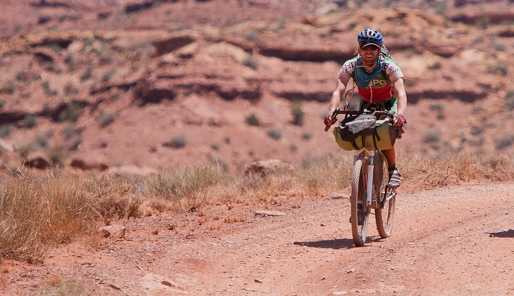
A smiling man with cycling gear rides a mountain bike on a dirt road in the desert
Stay safe out there. Wear your helmet.

NPS/Andrew Kuhn

Riding the backcountry and primitive roads of Glen Canyon National Recreation Area is a great way to enjoy the scenery of the Colorado Plateau. As more and more people turn to biking as a means to reach these scenic areas, it’s important to keep in mind some safe and ethical riding practices.


Respect the Land

  • Bicycles are vehicles and can do much damage to fragile desert soils and vegetation. Help us protect this special place by not riding cross-country, across slickrock, or on foot trails or closed roads. STAY ON DESIGNATED ROADS AT ALL TIMES.
  • There are NO AREAS where you may ride a bike along or from the shoreline of Lake Powell.
  • Overnight camping along roads within Glen Canyon National Recreation Area is permitted. You may also HIKE away from roads to camp without your bike. Carry a lock to secure your bike on the road. Riding or pushing your bike off road is not allowed. Remember always to carry all of your trash back out with you.
  • PACK IT IN, PACK IT OUT

Use of E-bikes

The term ''e-bike" means a two- or three-wheeled cycle with fully operable pedals and an electric motor of less than 750 watts ( I h.p.).

E-bikes are allowed in Glen Canyon National Recreation Area where traditional bicycles are allowed. E-bikes are prohibited where traditional bicycles are prohibited. Except where use of motor vehicles by the public is allowed, using the electric motor to move an e-bike without pedaling is prohibited.

A person operating an e-bike is subject to the following sections of 36 CFR part 4 that apply to the use of traditional bicycles: sections 4.12, 4.13, 4.20, 4.21, 4.22, 4.23, and 4.30(h)(2)-(5).

The use of an e-bike within Glen Canyon National Recreation Area is governed by State law.

Learn more about using e-bikes in National Park Service areas.


Be Prepared

  • Carry plenty of water—a MINIMUM of 1 gallon (4 liters) per person per day. You should also have a repair kit, extra tire tube and pump, and a first aid kit. ALWAYS wear a helmet and gloves for safety.
  • Be prepared for temperature extremes and sudden storms. Carry raingear and polypropylene or wool outerwear for strong winds. In summer, ride early or late in the day to avoid intense midday heat.
  • Terrain here can be extremely rugged. Watch out for other cyclists and vehicles. Use extreme caution on steep descents.
  • Frequent snacking on easily digested, high-energy foods is much better than eating two or three large meals a day. Some good choices might be bananas and citrus to replace electrolytes, breads, granola bars, fruit and nut mixtures, and similar items.
  • Visitor use at Glen Canyon National Recreation Area is increasing. If you are looking for solitude, plan on visiting less popular sections of the park and avoid weekends and holidays.
 

Area Rides

Wahweap

Warm Creek Road (#230): 13+ miles. A popular road from Big Water, Utah to various points. This road is rocky and very muddy when wet.
Crosby Canyon Road (#231): 13 miles from Big Water to the lake. Part of this road runs through a wash, so be on the lookout for flash floods during storms.
Alstrom Point Road (#264): 8 mile sandy spur off Warm Creek Road to a spectacular overlook.
Grand Bench Road (#262): 38 miles one way from the junction with Warm Creek Road. This road contains sandy and difficult terrain, making it a very strenuous trip.

Bullfrog/Escalante

Hole-in-the-Rock Road (#330): 13 miles from the Glen Canyon NRA boundary to the overlook of the historic crossing. This road is only intermittently maintained within the recreation area and is very rocky.
Purple Hills (#332): 12 miles from the Glen Canyon NRA boundary to Purple Hills. This rough road provides views of the Circle Cliffs.
Burr Trail (#531): The first 8 miles of this popular road are within Glen Canyon NRA. This road is well maintained and has both unpaved and chip-sealed sections. The entire road is 70 miles in length from Bullfrog to Boulder, Utah, and connects with many interesting side roads. This road receives much vehicular traffic, so watch out for cars and trucks.

Halls Crossing/San Juan

Hole-in-the-Rock Road (#450): 10 miles of this historic trail are within Glen Canyon NRA. This is a continuation of the pioneer trail from Escalante. (See Bullfrog/Escalante above.) This entire section of the trail from SR 276 provides for excellent long-range trips. The road is unmaintained, rough, and rocky, with steep and/or sandy stretches.
John’s Canyon (#456): 8-mile spur from SR 316. This rocky road provides some hiking access to John’s Canyon. The road is closed beyond 8 miles, on the west side of John’s Canyon at the National Recreation Area Boundary.

Orange Cliffs

Flint Trail (#633): It is 53 miles between Hans Flat and Hite. This is a rocky road with sandy portions and steep grades on the switchbacks. Camping south of Clearwater Canyon is currently permissible with no permit.
North Hatch Canyon (#730): 3 miles within Glen Canyon NRA. The entire road offers interesting geologic views. This extremely rough road eventually leads to the Dirty Devil River. Fording the river to Poison Spring Canyon is not always possible.
Panorama Point/Cleopatra’s Chair (#744, 774, 775): It is 10 miles from Hans Flat to Cleopatra’s Chair. This moderately rough, rocky road leads to excellent views.
Land’s End/Big Ridge (#731): Spur road. It is 16 miles from the Flint Trail to Land’s End. This road covers a generally flat, wooded terrain to scenic views.
Standing Rocks (#756): 13-mile spur from the Flint Trail. This road has sandy and rough slickrock sections. Access to the Maze District of Canyonlands National Park is provided.
Brown’s Rim (#632): 4 miles within Glen Canyon NRA from SR95 junction along Brown’s Rim. This maintained dirt road provides a possible loop trip through BLM lands back to SR 95.
Blue Notch (#651): Access is off SR95 at mile post 59 approximately 22 miles from the lakeshore. This is a remote road with steep terrain.
Elaterite Basin (#763): 26 miles one way from the base of the Flint Trail switchbacks to the Buttes of the Cross and the Green River. This road has some sandy sections.

Last updated: October 7, 2020

Park footer

Contact Info

Mailing Address:

PO Box 1507
Page, AZ 86040

Phone:

928 608-6200
Receptionist available at Glen Canyon Headquarters from 7 am to 4 pm MST, Monday through Friday. The phone is not monitored when the building is closed. If you are having an emergency, call 911 or hail National Park Service on Marine Band 16.

Contact Us