Last updated: February 13, 2024
Thing to Do
Driving to Alstrom Point
NPS
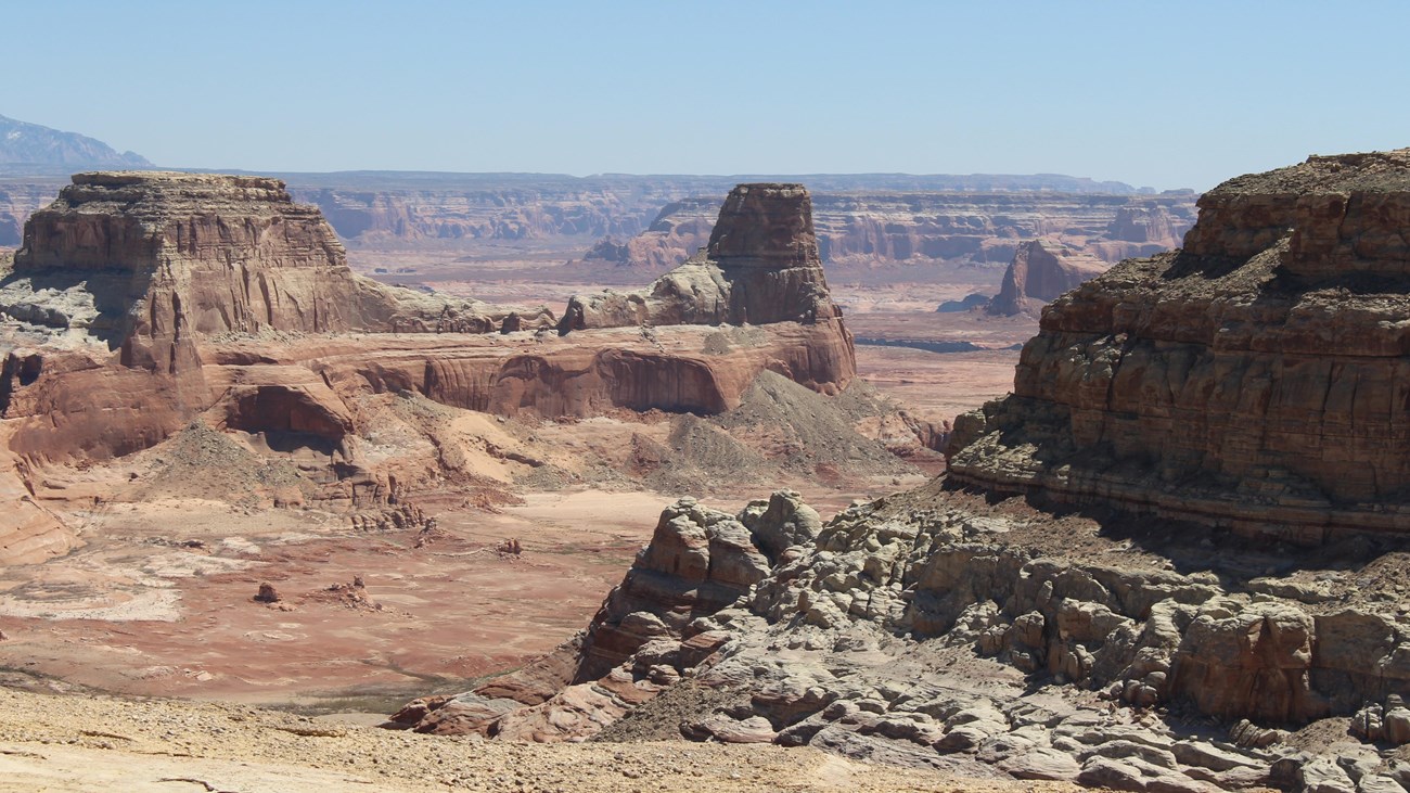
Travel Glen Canyon’s Moonscape Backcountry On The Way to Alstrom Point
Located at the southwest region of Glen Canyon National Recreation Area along the border with Grand Staircase-Escalante National Monument, the 46 mile (74 km) long drive to Alstrom Point offers excitement for the adventurous explorer. Views of features in the Tropic Shale, where marine reptiles once swam the Cretaceous Seas, then up on the Romana Sandstone with panoramic views of the ever changing canyons of Lake Powell in Glen Canyon, await the traveler who wishes to explore this interesting road. There are side hikes at Wiregrass Canyon and Resurrection Canyon, side drives at Crosby Canyon, any hoodoo formations to stop and see, and a number of side roads that lead up Smoky Mountain and onward to Escalante UT.
To fully enjoy the journey always be well prepared. Make sure you have plenty of water, an emergency car kit, proper footwear, sunscreen, a hat and a means of communication. There are no facilities and no shade anywhere on Romana Mesa including Alstrom Point. Be confident that your vehicle can drive on these roads. If the vehicle has high enough clearance, it can. If you can't clear that first creek crossing, your vehicle cannot handle the drive.
For latest road conditions and travel information, check in at the nearest Visitor Center or check the most recent Road Report. If you are having an emergency, call 911.
Tips for a safe and enjoyable trip
- Pack out what you pack in. Carry out all trash and food scraps. Help keep wildlife wild by not feeding them human food.
- Always take plenty of drinking water with you. One gallon per person per day is recommended. Make sure to eat to balance electrolyte loss and bring snacks.
- Flash floods happen in an instant here. A storm can appear out of nowhere, sending water flooding into a canyon (Specifically, into Wahweap Creek, and if you are on the other side of it, you are camping there until the creek calms down). If you see or hear a threat of rain or storms, DO NOT RISK your safety for the scenery. Never enter washes or narrow canyons when it is raining or threatening to rain.
- Check with a ranger or official for road and weather conditions before starting your trip.
- Warning: there is limited cell service in this area. Leave your trip itinerary with someone so you can be located in case of car trouble or other mishaps.
- Leave the scenery as it is. Do not write or carve on rocks, do not disturb plants or wildlife. Take only pictures, visit with respect and leave no trace. Pack out everything you bring in, most importantly pack out all human waste and trash. This is the desert, and mostly rock, so burying waste will be almost impossible, and the waste will not decompose.
Please note
Although in dry weather the roads to Alstrom Point are easily accessible to passenger cars, wet weather may make the roads impassable even for 4-wheel drive vehicles. Check with rangers or local officials for weather and road conditions. Recreational Vehicles and trailers are not recommended.
Details
Duration
4-48 Hours
It does take around four hours to just drive to Alstrom Point and back, but there are places to stop, walk around, and camp to the night if you wish.
Activity
Scenic Driving
-
Only attempt in dry weather forecast or when road has dried after rain (keep your return trip in mind too. If it starts raining while you are out there, you are staying out there). High clearance 4WD are necessary for the last few miles, and high clearance 2WD is recommended for the entire drive. Most of the Smokey Mountain/Croton Road is graded periodically, but not regularly.
-
Driving time is a minimum of 2 hours each way. It is unsafe to attempt the drive at night. Bring camping gear for sunset/sunrise photography.
-
Leave your trip itinerary with someone back in the real world so you can be located in case of car trouble or other mishap. Cell service is unreliable. Be prepared for emergencies.
-
Alstrom Point Is an unimproved location with no facilities. Bring water and seasonally appropriate outdoor gear. Pack out everything you bring in, most importantly pack out all human waste and trash. Take a few wag bags.
-
Leave the scenery as it is. Do not write or carve on rocks; do not disturb plants or wildlife. Take only pictures; leave behind nothing
Pets Allowed
Yes
Pets are allowed in most parts of Glen Canyon National Recreation Area. Pets must be on a leash that is no longer than six feet in length. Owners must clean up solid pet waste.
Activity Fee
No
There is no additional fee to drive to Alstrom Point.
Location
Alstrom Point (point is at the end of the drive)
Driving Directions to Alstrom Point
Mileage and GPS locations were to the best of our knowledge, and did not account for any side quests. Cellular coverage is spotty along the drive, so some points may vary from device to device.
From Carl Hayden Visitor Center at Glen Canyon Dam: Drive north on US89 approx 12 miles to Big Water UT.
Turn right across from the entrance to Grand Staircase Escalante Big Water Visitor Center entrance onto Ethan Allen Rd. Reset your odometer.
Mile 0.25: TURN RIGHT at sign attached to chain-link fence for “Glen Canyon National Recreation Area and State Highway 12” onto the Smokey Mountain/Croton Rd (Rte 230).
Mile 0.80 (N37°4’51” W111°39’6”): Cross Wahweap Creek and continue on a semi-improved road (sometimes paved, sometimes not). If the creek is running too fast or high to cross, your trip ends here. Running water only six inches deep can move a vehicle if it is flowing fast enough. Turn around, don’t drown. Come back another day.
Mile 3.7 (N37°4’4” W111°36’21”) This is the unimproved parking area for people who want to hike Resurrection Canyon on the right; or go view balanced rocks on the left.
Mile 4.9 (N37°4’39” W111°35’23”) parking area/trailhead for Wiregrass Canyon. Wiregrass Canyon is a partially improved, partially technical hike through a canyon that is wider in some parts and narrow in others. This sandy wash takes you through a small canyon and requires some scrambling and detours. Look for cairns (small stacks of rocks that act as trail markers) to lead you out. Wayfinding required. At current lake levels, the trail does not reach the water. Round-trip distance 4 miles (6.4 km)
Mile 9.2 This is the turnoff to Crosby Canyon, which leads to Warm Creek Bay (Rte 231). At current lake levels, the shoreline at Warm Creek is closed to vehicles. Keep straight.
Mile 12.9 (N37°7’49” W111°29’43”) This is the intersection of Smokey Hollow (left fork) and Smokey Mountain/Croton Road (the road you are on). The signs indicate some history and recreation opportunities in Grand Staircase-Escalante National Monument. Bear right and keep going.
Mile 12.9 (N36°44’5” W111°35’24”) Another intersection. At this one, the left branch is the continuation of Smokey Mountain Road, which eventually climbs up the cliffs in the distance and ends up at Escalante, UT. Bear right, past the Grand Staircase-Escalante National Monument sign on the Croton Road.
Mile 18.2 (N37°7’50” W111°24’53”) This is the turnoff for the Alstrom Point road. It is significantly less maintained than the Smokey Mountain/Croton roads you have been on. Now would be a good time to turn on the 4WD. The sign at the turn indicates that this is Rte 264 and the Alstrom Point overlook is in five miles. If you somehow miss this sign and continue on Croton Road, you will soon cross a cattle guard. This means you have gone too far. Turn around and come back.
About a mile before this turnoff, there was another road that can technically go to Alstrom Point, but it is not recommended for highway vehicles.
The road gets sketchy: it may disappear into sandstone, there are a few social trails that lead in various directions, there are a few minor hills to climb. On the last stretch, try to follow the largest of the road tracks to minimize impact on the landscape. There are several places with great views; you can walk the last couple of miles if it is too rough, or keep going until you can't go any further. GPS for the end of the road: N37°03’54” W111°21’83”
You will be on sandy rocks overlooking 1,000' cliffs. Sunrise and sunset are best times, but interesting weather may make for great photos at any time of day.
Return to the highway the way you came.
Reservations
No
Season
Year Round
The weather on the drive to Alstrom Point is usually typical for the high deserts. Summers are extremely hot with no shade. Winters are moderately cold with night time lows often below freezing. Spring weather is highly variable and unpredictable with extended periods of winds and possible snowmelt flash floods. Fall weather is usually nice and mild, a great time to beat the heat (and the crowds!).
Temperatures can range from 110° F (38°C) in June & July to 0° F (-16°C) in December & January. Precipitation is generally light (less than 6 inches [15.2cm] annually) though heavy rains and flash flooding is possible during the summer and fall "monsoons." Parts of the road may be impassable in inclement weather.
Time of Day
Day, Dawn, Dusk
We do not recommend driving this winding road at night. However, the most magnificent views will be sunrise and sunset, so plan ahead to camp overnight and get the best evening/morning views.
Accessibility Information
The roads are rough dirt almost the whole way. Although in dry weather the roads to Alstrom Point are easily accessible to high clearance passenger cars, wet weather may make the road impassable even for 4-wheel drive vehicles. Check with rangers or local officials for weather and road conditions. Recreational Vehicles and trailers are not recommended.
On top of Romana Mesa, there are no trails or railings. The ground is uneven and can drop hundreds of feet with no warning. There are no comfort facilities, shade, or other services.