News Release

|
Subscribe
|
Contact: Matthew Cahill, Public Information Officer, 907-697-2230
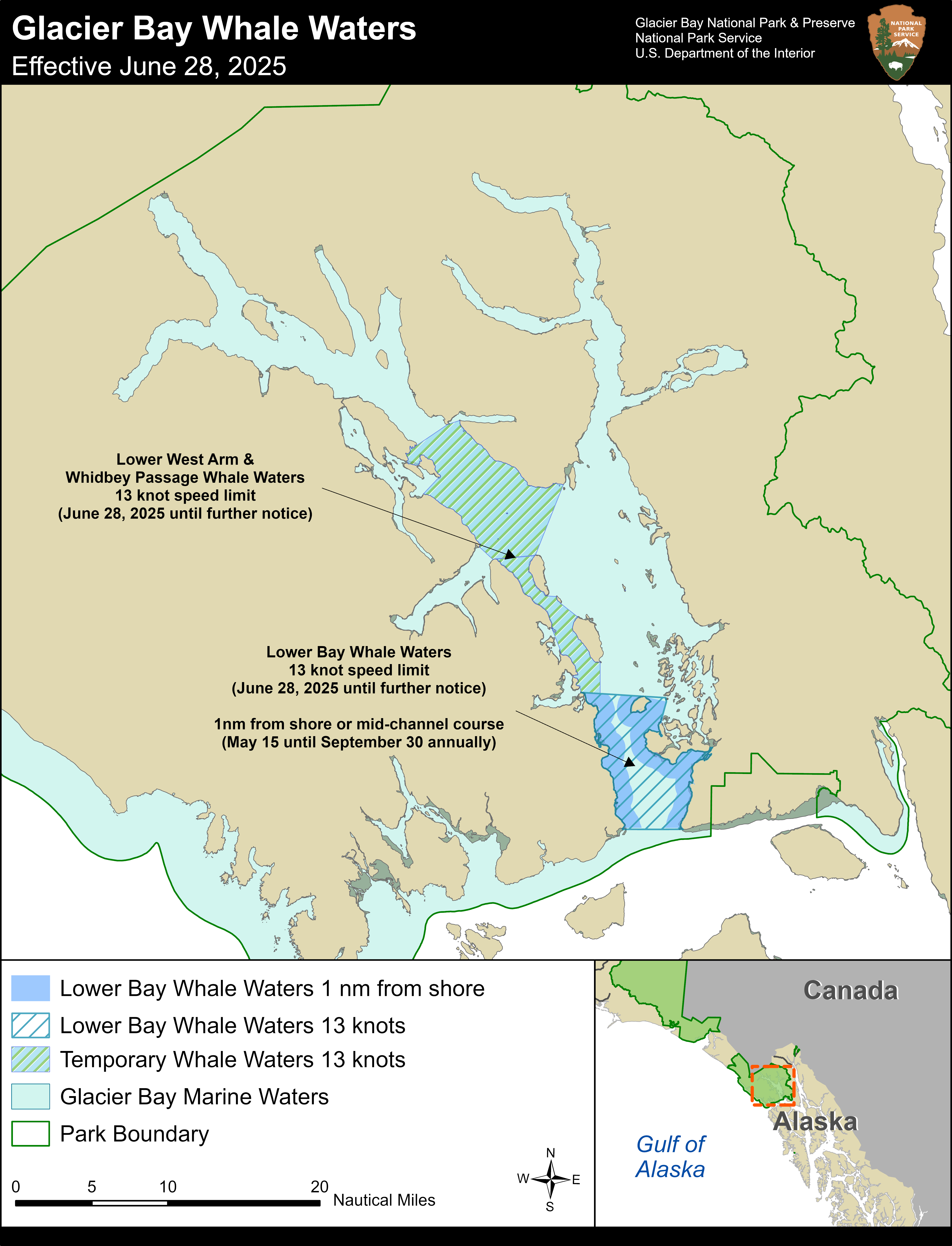
BARTLETT COVE, ALASKA – Glacier Bay National Park and Preserve Acting Superintendent Joni Seay announced today new whale waters areas in the lower West Arm and Whidbey Passage with a vessel speed limit of 13 knots through the water, to protect 25 or more humpback whales that have been feeding in this area. She also announced that in the Lower Bay Whale Waters, a 13-knot speed limit is being implemented due to increasing numbers of humpback whales. The attached map shows the boundaries of these areas. These updated operating requirements are effective from 5 AM Saturday June 28th until further notice.The new West Arm Temporary Whale Waters area is defined by the following corners:
- The points defining the mouth of Geikie Inlet;
- The northern tip of Drake Island;
- Tlingit Point;
- The points defining the mouth of Tidal Inlet;
- The points defining mouth of Blue Mouse Cove, including the waters in Blue Mouse Cove, and;
- The points defining the mouth of Hugh Miller Inlet.
The new Whidbey Passage Temporary Whale Waters area has the following boundaries:
- Northern Boundary: A line from the northern tip of Drake Island to the southern point of the mouth of Geikie Inlet;
- Eastern Boundary: A line from the southern tip of Drake Island to the northern tip of Francis Island, from the southern tip of Francis Island to the northern tip of Willoughby Island, and due south from the southern tip of Willoughby Island to the Lower Bay whale waters boundary.
- The Southern Boundary is contiguous with the Lower Bay whale waters.
- The waters of Fingers Bay and Berg Bay are not included.
The designated Lower Bay Whale Waters (defined in 36 CFR Subpart N,13.1174), include the waters extending from the mouth of Glacier Bay to a line drawn between the northern tip of Strawberry Island and the northern tip of Lars Island. This boundary is shown on NOAA nautical charts of Glacier Bay. In addition to the new 13-knot speed limit, vessels 18 ft or more in length are required to remain at least 1 nautical mile from shore or maintain a mid-channel course in this area May 15-September 30 annually.
Boaters should proceed cautiously in all areas where whales may be present because whales may surface in unexpected locations, posing a hazard to both the vessel and the whale. Vessels are prohibited from operating within ¼ nautical mile of a humpback whale in Park waters, including those Park waters outside Glacier Bay proper. Vessels positioned within ½ nautical mile of a humpback whale are prohibited from altering their course or speed in a manner that results in decreasing the distance between the whale and the vessel. Speed and course restrictions in whale waters are intended to reduce the disruption of feeding humpback whales and to lower the risk of whale/vessel collisions, as authorized by Title 36 of the Code of Federal Regulations, Subpart N, 13.1174.
Boaters are advised to verify whale waters designations prior to entering Glacier Bay by telephoning (907) 697-2627 or by contacting KWM20 Bartlett Cove on marine VHF radio.
Last updated: June 27, 2025
