An official website of the United States government
Here's how you know
Official websites use .gov A
.gov website belongs to an official government
organization in the United States.
Secure .gov websites use HTTPS A
lock (
) or https:// means you've safely connected to
the .gov website. Share sensitive information only on official,
secure websites.
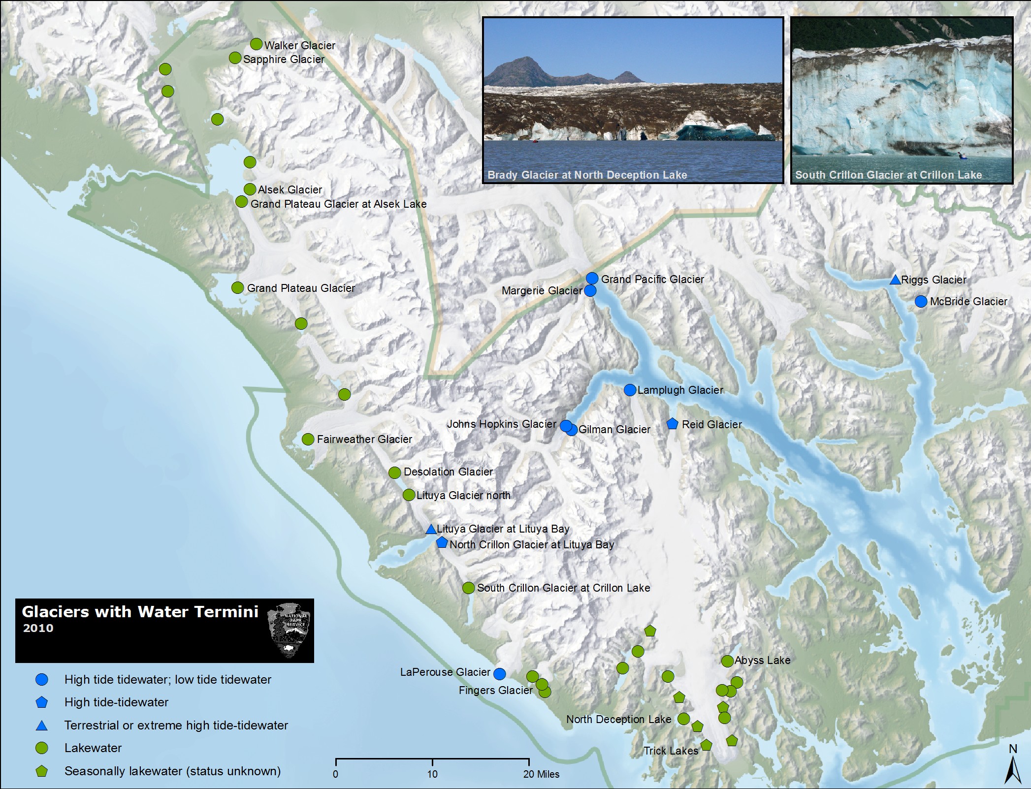
At first glance, it may seem that all glaciers look alike, but as you spend time getting acquainted with the glaciers of Glacier Bay, you will soon realize that each is unique. Look all around for glaciers during your voyage of discovery. There are over 1,000 glaciers in Glacier Bay. Most are high in the mountains, but a few notable glaciers extend all the way to the sea.
In general, tidewater and terrestrial glaciers in the Park have been thinning and slowly receding over the last several decades. Reduced snowfall in their ice-field sources and warmer temperatures during winter, coupled with an apparent reduction in cloud cover and precipitation during the summer, are the probable causes of this trend. Johns Hopkins Glacier is currently the only advancing tidewater glacier on the eastern side of the Fairweather Range, while the LaPerouse Glacier draining from the western side of the Fairweather Range continues to have a relatively stable tidewater margin, being the only glacier in North America that calves periodically directly into the Pacific Ocean. In addition glaciers within Lituya Bay continue to show advance.
Johns Hopkins is the park's most active tidewater glacier
Tidewater Glaciers
Johns Hopkins Glacier is about 1-mile wide and 225-300 feet high at the terminus. It is formed from numerous tributary glaciers, many of which extend 12 or more miles into the surrounding peaks. About 50 medial moraines develop from the joining of these tributary glaciers. The debris in these moraines can be seen in the ice face and extending up-glacier as prominent black bands. This debris is transported in and on the ice and released either by melting of the ice face or calving of icebergs into Johns Hopkins Inlet. Of note, Johns Hopkins is characterized by submarine calving - calving below the water surface caused by breaking off of ice from an “ice foot” that extends from the basal part of the glacier. These “basal bergs” rise suddenly and unexpectedly, emerging, sometimes explosively, without warning at the water surface. Melt-water from the glacier is discharged from submarine tunnels or conduits located near both the eastern and western edges of the glacier. Sometimes this water emerges at the inlet surface as fountains. Black legged kittiwakes are commonly seen diving, floating, and feeding where the meltwater upwells along the ice face.
The glacier flowed down the main valley at about 3,000 feet per year, or about 8 feet per day, according to observations made in the late 1970’s by S. Brown and others. Today, Johns Hopkins Glacier's flow rate is approximately 5-12 ft per day according to ITS_LIVE satellite data.
Adjacent to Johns Hopkins is Gilman Glacier. Johns Hopkins joined Gilman Glacier at its eastern edge in about 1990. Since then, the two glaciers have separated and joined several times. The two glaciers are currently attached at the eastern edge of Johns Hopkins after being separated as recently as 2016. Where they meet, a 150 to 200 foot steep ice face is created. Unlike Johns Hopkins, Gilman does not have many tributary glaciers and tends to look more clean. A visit to the face of Johns Hopkins and Gilman glacier on a tourboat or private vessel is a special experience.
Grand Pacific Glacier is 1.35 miles wide at the terminus, with an ice face ranging from 65-165 feet, and a length over 20 miles long. Grand Pacific Glacier's flow rate is approximately 0.5-1 foot per day, according to satellite data. The glacier last joined the edge of Margerie Glacier in 1992, but these glaciers are no longer together due to the recession of Grand Pacific. A small stream presently flows between the two termini. Unlike Margerie, Grand Pacific is now grounded and does not have a dramatic ice front. Behind the terminus, the ice may thicken to 900 feet or more, although evidence shows the ice has been thinning over the last several decades. Prior to 2015, the western two thirds of the ice in Grand Pacific Glacier's ice front originated from the tributary Ferris Glacier. But more recently, Landsat imagery has shown that a meltwater stream now separates Grand Pacific from Ferris Glacier. Therefore, nearly all of the ice in the ice front is now from Ferris Glacier. The Ferris Glacier contains a huge amount of rock and dirt that it has removed from nearby mountainsides, giving the ice its brown or 'dirty' appearance.
Lamplugh Glacier in 2017. Evidence of a massive landslide is visible in the upper middle. Lamplugh Glacier is 0.9 miles wide, 165 feet high at the face, and over 19 miles long. Its flow rate is approximately 0.75 - 1 foot per day. Noted for the intense blue color of it's ice, Lamplugh is fed by the Brady Icefield, which lies east of the Fairweather Range. As temperatures warm, and snowlevels rise, the Brady Icefield accumulation areas appear to be shrinking year after year. The terminus is now grounded, and only at high tides does saltwater reach the ice face. A large subglacial stream flows from the central part of the terminus, often creating large caves in the face of the glacier. Such subglacial streams discharge large volumes of sediment-rich water into the fjord, filling the small embayment at the ice edge with brown to tan milky water. Since 2010, outwash has built up extensive mudflats along the entire face of the glacier.
Margerie Glacier and the Glacier Bay daily tour boat operated by the Glacier Bay Lodge. Margerie Glacier is an icy highlight of any visit to Glacier Bay National Park, and a primary destination for visitors on sailboats, kayaks, tourboats, and cruise ships. It is about 0.85 miles wide, with an ice face that is about 200 feet high above the waterline. The glacier is about 21 miles long and begins in snow-fields in the Fairweather Range where elevations exceed 9000 feet. The ice flows about 3-7 feet per day. Margerie Glacier last joined Grand Pacific Glacier in 1992, but they have since separated as Grand Pacific recedes. Margerie’s terminus was relatively stable in position through the 90’s; however, about 1998 the northern third of the terminus began a slight recession, forming a small embayment within the ice face. Over the years, this part of the terminus has thinned and the embayment has expanded. In 2017, this section experienced dramatic changes with deep embayments and a large mass of bedrock now exposed. Perpetual meltwater discharges from subglacial streams below the water surface within the central area of the glacier resulting in upwellings and occasionally fountains. Where the ocean is disturbed by meltwater streams and calving icebergs, flocks of black-legged kittiwake gulls swarm and glean small marine creatures from the surface.
Reid Glacier is about ¾ mile wide, 150 feet high, and over 10 miles long. Like Lamplugh Glacier to the northwest, it originates in the Brady Icefield. The glacier is now fully grounded. Sediment deposited from streams draining out of the glacier on the eastern and western margins is gradually filling the inlet in front of the glacier, the deposits being exposed at low tides. The center of the glacier continues to slowly recede at about 30 to 50 feet per year, while the remainder of the margin has been receding at about 30 feet per year or less while progressively thinning. Crevasses that characterized Reid Glacier within its terminus region since the early 1900’s are slowly closing as flow rates decrease and the terminus becomes terrestrial. The glacier filled all of Reid Inlet in 1899 and has slowly receded to its current position since that time. On the walls of the fjord, lateral deposits of the glacier extend from near the waterline up and along the bedrock face, and mark the positions and thickness of the ice at locations where it remained stable for some period of time during this overall period of recession.
McBride Glacier has receded significantly in the last decade
NPS Photo / T. Lewis (2021)
*Note: Statistics beyond this point have not been updated since 2010. The majority of glaciers in the park have receded or thinned in the last decade.
McBride Glacier is about ½ mile wide and 14 miles long. Its ice face is approximately 200 feet high above the waterline and currently extends about 270 feet below it. Ice flow rates have not been measured, but are estimated to be on the order of 3000 feet per year. McBride Glacier has been steadily thinning and retreating by calving since the 1960s after its separation from Muir Glacier. Submarine moraines mark several positions in McBride Inlet where the ice margin was stable in position for several or more years. Over the last 5 years, retreat rates have increased with occasional massive calving events releasing enough large icebergs to fill all of McBride Inlet. The rate of retreat accelerated as the ice margin receded from water with depths of 60 feet at the edge of the ice face and a proglacial basin of around 120 to 140 feet depth in 1999, into a deeper basin where depths were measured to be around 250 feet or deeper. In the summer of 2003, a significant amount of calving had occurred, more so than in the previous two years. A significant portion of the northern half of the ice margin had receded ~ 85 meters in less than an estimated 7 day period. With deep water at its margin, McBride Glacier is expected to continue receding at a fairly rapid pace.
Muir Glacier is ½ mile wide, and about 13 miles long. The former major attraction of Glacier Bay, this glacier is no longer tidewater. During its catastrophic retreat that began in 1899, flow and calving rates were extreme. Muir Glacier flowed at about 6,000 feet per year, or about 16 feet per day as late as 1979. Today, ice flow near the terminus is about 150 feet per year, or 0.5 feet per day based on GPS measurements. The continual retreat of the glacier from the mouth of Muir Inlet produced the transition of the glacier from one that was tidewater with a submarine grounding line to one that became terrestrial in 1993. The terminus position is relatively stable at this time; however, the ice is progressively thinning and surface crevasses that characterize tidewater glaciers are generally no longer present in the terminus region. The large mounds of sediment that parallel the ice margin are formed during winter when ice melt rates are much lower and ice advances seasonally, carrying and shoving deltaic sediments ahead of it. Thus the mounds are actually ice-cored, and with slow ice flow in summer and melting, sediments are gradually shed from them, exposing the ice and allowing it to melt.
Riggs Glacier is about ¾ mile wide at the terminus and about 14 miles long. Once a major attraction within the east arm, the terminus became mostly grounded during the mid-1980s as an outwash delta built across the southern margin. Riggs Glacier has been thinning progressively over the past two decades and is expected to continue thinning and slowly receding. Ice recession has been averaging about 20 to 30 feet per year for the last 5 years. Ice flow rates have not been measured but are estimated to be in the range of 100 to 400 feet per year across the ice margin.


