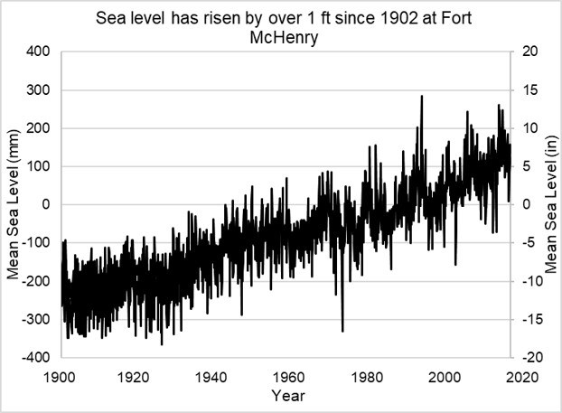
Sea Level Rise at Fort McHenry

A graph depicting the rise in sea level from Fort McHenry to present day. The sea level has risen over 1 foot.
Since 1902, sea level has risen at an average rate of 0.13 in/yr at Fort McHenry and could rise an additional 6.43 feet by 2100.

Baltimore, MD tide gauge (NOAA).

Sea levels are rising

Since the industrial revolution, we have burned fossil fuels such as coal, oil, and natural gas to power our societies. This process emits greenhouse gases like carbon dioxide and methane which trap heat in our atmosphere and cause global climate change. Of the many challenges posed by climate change, rising sea levels are the most immediate threat to coastal areas. Sea levels are rising due to:
  • ice melt: melting glaciers and permafrost increases the amount of water in the ocean, and

  • thermal expansion: heat causes water to expand, increasing the space that water occupies.

 
Fort Sea Level Rise Map showing a rise in 6ft of sea level would flood many parts of the fort.
Satellite imagery of Fort McHenry with  6 feet of sea level rise overlaid in light blue. These show conditions independent of storm surge.

NOAA

The future of sea level rise

The more greenhouse gases are emitted the more sea levels are projected to rise. The future of sea level rise is dependent on emissions scenarios, higher emissions will cause sea levels to rise further. The most severe impacts of climate change can still be avoided by significantly reducing emissions.

NOAA projects that the different tides of the tidal Patapsco River could drastically shift as well. By 2050, the intermediate low, and intermediate tides will rise on average by one to one and a half feet from where it is now. The intermediate high tide is project to raise by just over two feet as well.

The projections span out to the year 2100 as well, showing even higher changes The intermediate low in this year is projected to be two feet higher than normal, a 100% increase from the projections for 50 years prior. That trend does not conclude there, where the intermediate and intermediate high projections raise to four feet and 6 and a half feet respectively.


Sea Level Rise at Fort McHenry

The park's proximity to the tidal waters of the Patapsco River means it is threatened by rising sea levels and storm surges. Climate change is making storm events that flood the lawn and deposit debris and litter more frequent; threatening the daily use of the park grounds and trails to run, bike and picnic. Fort McHenry is historically significant as the birthplace of the U.S. national anthem,as a Union prison during the Civil War, as a hospital during World War I, and as a Coast Guard base during World War II. Protecting it from the threat of sea level rise is important for maintaining historic and cultural integrity
 
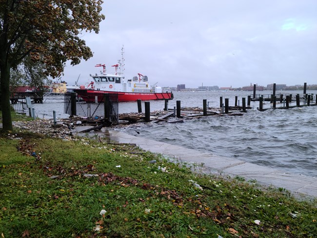
Pier at Fort McHenry is destroyed by storm surge.
Wind, rainfall and air pressure combine to create a storm surge that breached Fort McHenry’s sea wall in October 2021. Extreme weather events are projected to become more common & severe due to climate change.

NPS

Fort McHenry's historic sea wall has protected the park from erosion and encroaching water for decades. However, water levels above six feet will inundate and render the sea wall ineffective. Water levels above six feet will occur more often as sea levels rise and as storm surges increase in regularity and severity. Surging waters threaten to reach the visitor center, damaging exhibits and historic collections.

 
Volunteers picking up trash in the wetlands
Volunteers in the Fort McHenry wetland during a cleanup event.

National Aquarium

The National Aquarium manages the nearby Fort McHenry wetlands, one of the only sections of natural shoreline left in Baltimore City. The marsh serves as a buffer, improving water quality and providing habitat in the harbor. Unfortunately, if marsh growth cannot outpace rising waters climate change may soon drown this ecosystem.

 
FOMC Aerial
The fort viewed from above gives a sense of its proximity to the water. High tides and storm surges can bring water and debris onto the park grounds. Higher sea levels mean storms will bring water further inland over the park lawn than usual during storm events.

NPS

What is Fort McHenry doing to help?

The park has taken measures to reduce their consumption of fossil fuels and their impact on the environment.

The Visitor Center:

  • is LEED Silver Certified, meaning it meets "green building" requirements;
  • features a geothermal system that better regulates heat and increases energy efficiency by 20-30%; and
  • has special windows and roofing that reduce heat absorption by the building, reducing the need to cool in warmer months.

The park:

  • features low-flow water systems that use half the water of tradition systems (they save over 325,000 gallons of water per year!) and
  • has a native plant garden that uses less water and fertilizer than other plants and doesn't need to be mowed.
 

Aditional Resources

  1. https://coast.noaa.gov/slr/: A NOAA SLR viewer tool to access local sea level rise projections at tide gauges and visualize sea level rise scenarios (2017).
  2. https://tidesandcurrents.noaa.gov: Access water levels, tide predictions, and other conditions along coasts.
  3. NOAA Coastal Flood Exposure Mapper: A tool to visualize coastal hazards as well as societal, infrastructure, and ecosystems exposure to those hazards
  4. Fort McHenry Sea Level and Storm Trends: A previous (2014) sea level rise report for Fort McHenry.
Note: The sea level rise projections, storm surge projections, and other information presented here are for general educational and awareness purposes only. They should not be used for site-specific analysis, navigation, permitting, or legally binding activities.

Last updated: September 15, 2022

Park footer

Contact Info

Mailing Address:

2400 East Fort Avenue
Baltimore, MD 21230

Phone:

410 962-4290 x250

Contact Us