Guidelines for Rehabilitating Cultural Landscapes
Topography
Identify, Retain, and Preserve Historic Features and Materials
![]()
Identifying, retaining and preserving the existing topography. Documenting topographic variation prior to project work, including shape, slope, elevation, aspect, and contour. For example, preparing a topographic survey.
Evaluating and understanding the evolution of a landscape’s topography over time. Using archival resources such as plans and aerial photographs or, in their absence, archeological analysis techniques to understand the historic topography.
![]()
Undertaking project work that impacts topography without undertaking a topographic survey.
Executing project work without understanding its impact on historic topographic resources, for example, watershed systems.
Protect and Maintain Historic Features and Materials
![]()
Protecting and maintaining historic topography by use of non-destructive methods and daily, seasonal and cyclical tasks. This may include cleaning drainage systems or mowing vegetative cover.
![]()
Failing to undertake preventive maintenance.
Utilizing maintenance methods which destroy or degrade topography, such as using heavily weighted equipment on steep or vulnerable slopes.
Repair Historic Features and Materials
![]()
Repair declining topographic features. For example, re-excavating a silted swale through appropriate regrading or reestablishing an eroding agricultural terrace.
![]()
Destroying the shape, slope, elevation or contour of topography when repair is possible.
Replace Deteriorated Historic Materials and Features
![]()
Using existing physical evidence of the form and composition to reproduce a deteriorated topographic feature. If using the same kind of material is not technically, economically, or environmentally feasible, then a compatible substitute material may be considered. For example, re-establishing eroded bunkers or ramparts in a battlefield with a substitute soil mix that supports improved drainage and health and vigor of ground cover plant materials.
![]()
Removing a topographic feature that is deteriorated and not replacing it, or replacing it with a new feature that does not convey the same visual appearance. For example, changing stepped terracing to a curved slope.
Design for the Replacement of Missing Historic Features
![]()
Designing and installing new topographic features when the historic feature is completely missing. It may be an accurate restoration using historical, pictorial and physical documentation or a new design that is compatible with the shape, slope, elevation and contour of the historic topography. For example, installing an artificial jetty to replace one lost to beach erosion.
![]()
Creating a false historical appearance because the replacement feature is based on insufficient historical, pictorial and physical documentation.
Introducing a new topographic feature that is incompatible in shape, slope, elevation, aspect and contour.
Alterations/Additions for the New Use
![]()
Designing new topographic features when required by the new use so that they are as unobtrusive as possible and assure the preservation of the historic landscape. For example, designing and installing drainage systems to protect historic topographic features.
![]()
Placing a new feature where it may cause damage, or is incompatible with historic topography. For example, failing to provide proper drainage for a new feature which results in the decline or loss of topographic features.
Locating a new feature in such a way that it detracts from or alters the historic topography. For example, obscuring a historic shoreline through the construction of a new breakwall.
Introducing a new feature in an appropriate location, but making it visually incompatible in terms of its size, scale, design, materials, color and texture. For example, installing berms to screen new parking, but using incongruous topographic shape and contour.
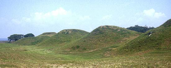
The earthworks at Fort Fisher guarded the entrance up the Cape Fear River to Wilmington. Recent inventory and evaluation of the earthworks located in Kure Beach, NC, will insure their ongoing care and management. (NPS)
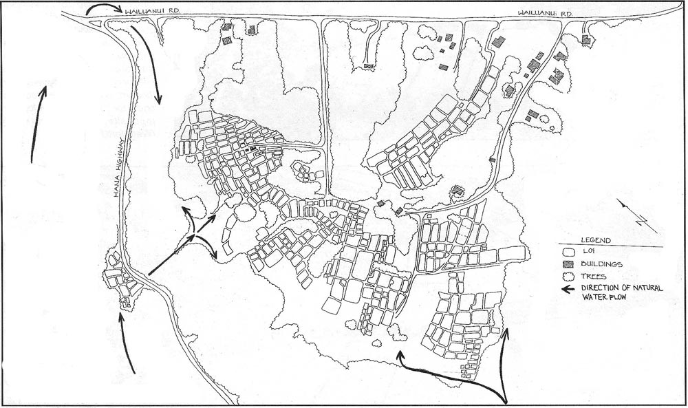
The central portion of the Ke’anae peninsula contains the most tightly clustered concentration of taro “lo’i” in the area. The lo’i themselves are surrounded by convex earthen banks. These banks serve as topographic dividers between the fields as well as trails for foot traffic--one person; single file. The wider banks, some of which measure eight to ten feet, provide access for tractors and all-terrain vehicles. This plan documents dirt mounds that have survived in the Wailuanui Lo’i Complex. (Group 70)