Guidelines for Rehabilitating Cultural Landscapes
Circulation
Identify, Retain, and Preserve Historic Features and Materials
![]()
Identifying, retaining, and preserving the existing circulation systems prior to project work. All circulation features should be documented, from small paths and walks to larger transportation corridors such as parkways, highways, railroads and canals. Documenting alignment, surface treatment, edge, grade, materials and infrastructure.
Evaluating the existing condition and determining the age of circulation systems. For example, using aerial photographs to understand a transportation corridor’s change from a two-lane route to a six-lane highway.
![]()
Executing project work that impacts circulation systems without undertaking an existing conditions survey.
Undertaking work without understanding the significance of circulation systems. For example, changing road alignments and widths without a thorough evaluation of the historic road.
Protect and Maintain Historic Features and Materials
![]()
Protecting and maintaining circulation systems by use of non-destructive methods in daily, seasonal and cyclical tasks. This may include hand-raking, top-dressing, or rolling surface materials.
Utilizing maintenance practices which respect infrastructure. For example, cleaning out debris from drainage systems.
![]()
Failing to undertake preventive maintenance of circulation features and materials. For example, using a snow plow across a coarse textured pavement.
Using materials such as salts and chemicals, that can hasten the deterioration of surface treatments.
Allowing infrastructure to become dysfunctional. For example, permitting a failed drainage system to contribute to the degradation and loss of associated curbs or erosion of road shoulders.
Repair Historic Features and Materials
![]()
Repairing surface treatment, materials and edges. For example, by applying a traditional material to a stabilized subsurface base or patching a canal corridor retaining wall.
![]()
Replacing or destroying circulation features and materials when repair is possible. For example, not salvaging and reusing historic stone walk material.
Replace Deteriorated Historic Materials and Features
![]()
Using physical evidence of form, detailing and alignment to reproduce a deteriorated circulation feature. If using the same kind of material is not technically, economically or environmentally feasible, then a compatible substitute material may be considered. For example, replacing in kind decayed timber edging along a historic trail route.
![]()
Removing a circulation feature that is deteriorated and not replacing it, or replacing it with a new feature that does not convey the same visual appearance. For example, replacing a set of stairs with a wall or terrace.
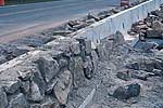
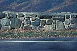
A 75-mile portion of Skyline Drive at Shenandoah National Park overlooking the Blue Ridge Mountains of Virginia required the rehabilitation of a 22”-high, dry-laid stone wall [left]. The new wall was built to a height of 27” whereas code normally requires a height of 36”. The wall was constructed of precast concrete, clad with split stone and mortar joints [center]. To achieve visual compatibility, recessed mortar joints were arranged in a random pattern [right]. (NPS and Paul Daniel Mariott)
Design for the Replacement of Missing Historic Features
![]()
Designing and installing new circulation features when the historic feature is completely missing. It may be an accurate restoration using historical, pictorial and physical documentation; or be a new design that is compatible with the historic character of the landscape. For example, reinstating a lost park entrance at a historic access point.
![]()
Creating a false historical appearance because the replaced feature is based on insufficient historical, pictorial and physical documentation.
Introducing a new circulation feature that is incompatible with the historic character of the landscape. For example, using a standardized concrete barrier along a historic parkway.
Alterations/Additions for the New Use
![]()
Designing and installing compatible new circulation features when required by the new use to assure the preservation of historic character of the landscape. For example, controlling and limiting new curb cuts, driveways, and intersections along a historic road.
![]()
Placing a new feature where it may cause damage, or is incompatible with the historic circulation. For example, adding new driveways, intersections, and “neck outs” along a historic road.
Locating any new circulation feature in such a way that it detracts from or alters the historic circulation pattern.For example, installing a new bike path when an existing historic path can accommodate the new use.
Introducing a new circulation feature which is in an appropriate location, but making it visually incompatible in terms of its alignment, surface treatment, width, edge treatment, grade, materials or infrastructure. For example, installing a new parking lot in a non-significant location, but utilizing paving materials and patterns which are incongruous with the landscape’s historic character.
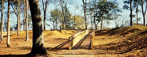 To provide access to the historic earthworks at the Stones River National Battlefield in Murfreesboro, Tennessee, an interpretive boardwalk was installed [preceding page and above] to allow visitors access to the resources while protecting the earthworks themselves. (NPS)
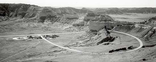
[top] This modern highway, which approximates the Oregon Trail approach to Mitchell Pass, was documented as part of a recent inventory project. Although the traffic noise is intrusive , the highway allow visitors to experience movement through the landscape, an important component of the trail. (NPS)
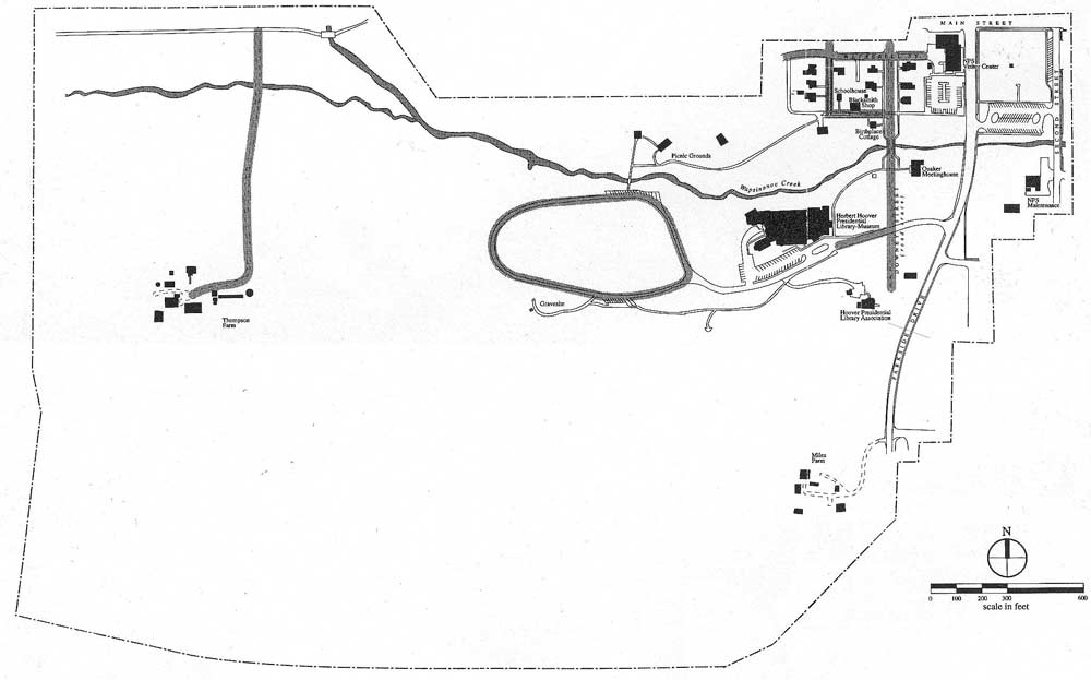
At the Herbert Hoover National Historic Site in West Branch, Iowa, the integrity analysis for the landscape’s circulation system revealed that a number of streets that existed historically have been substantially altered or are no longer extant. For example, Downey Street (the shaded area running north-south in the center of the historic core) formerly served as the entrance road into West Branch from the South. The road was re-routed and replaced with Parkside Drive (the larger road to its east). Today, the road trace of Downey Street still connects a number of nineteenth-century residences along its right-of-way. (Land and Community Associates)