An official website of the United States government
Here's how you know
Official websites use .gov A
.gov website belongs to an official government
organization in the United States.
Secure .gov websites use HTTPS A
lock (
) or https:// means you've safely connected to
the .gov website. Share sensitive information only on official,
secure websites.
This chart of campground amenities and fees is on the Fees & Passes page in a larger format.
Buffalo National River maintains numerous campgrounds throughout the park. They range from primitive with just vault toilets, no water and no designated sites to developed with electric and water hook-ups for RV camping.
Payment for all first-come, first-served sites can be made at the self-pay stations, which accept cash or checks only. You'll need the correct fee as no change is available at campgrounds or ranger stations.
Visit the Camping Rules page for specifics on how to make your trip safe and enjoyable!
Upper District
Upper Buffalo Wilderness to Carver
The upper or western end of the park includes 5 campgrounds. Fees for sites in these developed campgrounds are $16 - $20 per site per night with 6 people permitted on each site. Camping fees are charged during the season (March 13, 2026 through November 16, 2026) when water is available. Camping fees are not charged November 17, 2025 through March 12, 2026 when flush restrooms and water systems are shutdown.
Starting September 1, 2026, reservations will be required for all campsites at Kyles Landing Campground. Reservations must be made through Recreation.gov (www.recreation.gov) or by calling 877-444-6777. Reservations can be made the same day or up to six months in advance. Please note that cell phone service is unreliable in these areas, so it is strongly recommended to make your reservation before arriving at the campground.
Kyles Landing Campground is located approximately halfway between Ponca and Jasper, Arkansas, off Highway 74. The entrance road is gravel, steep, and very rough. A high-clearance, 4-wheel-drive vehicle is strongly recommended.
Tent camping only. Camper trailers, motorhomes, RVs, and camper vans are not permitted.
Campsites
33 tent campsites
Each site includes a picnic table, fire ring, and lantern hook.
Fees & Seasons
Campground is open year-round.
Amenities are available from March 13, 2026, through November 15, 2026.
The fee is $20 per night per site, first-come first-served, and is charged March 13, 2026, through November 15, 2026.
Exact cash or check only accepted at the self-pay station.
There is no fee to camp primitively over the winter season.
Amenities
Water and flush restrooms are available during the operating season of March 13, 2026, through November 15, 2026.
There are no shower facilities available.
Campsites accommodate 1 – 6 people per site.
A vault toilet remains open during winter months with limited servicing.
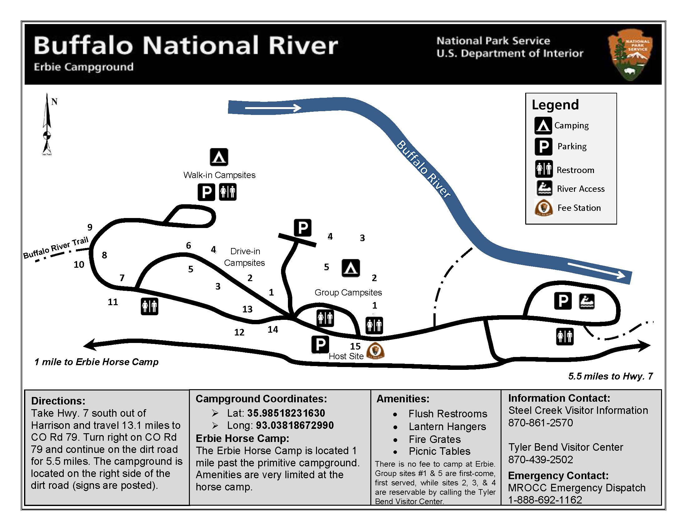
Starting September 1, 2026, reservations will be required for all campsites at Erbie Campground. Reservations must be made through Recreation.gov (www.recreation.gov) or by calling 877-444-6777. Reservations can be made the same day or up to six months in advance. Please note that cell phone service is unreliable in these areas, so it is strongly recommended to make your reservation before arriving at the campground.
Erbie Campground is located approximately 7 miles down a gravel road off Highway 7, north of Jasper, Arkansas. The campground offers:
14 drive-in campsites
13 walk-in campsites
Each campsite includes a picnic table, fire ring, and lantern hook.
Fees & Seasons
Campground is open year-round.
Amenities are available from March 13, 2026, through November 15, 2026.
The fee is $20 per night per site, first-come first-served, and is charged March 13, 2026, through November 15, 2026.
Exact cash or check only accepted at the self-pay station.
There is no fee to camp primitively over the winter season.
Amenities
Water and flush restrooms available during the operating season of March 13, 2026, through November 15, 2026.
Campsites accommodate 1 – 6 people per site.
Drive-in sites are suitable for tent or RV camping.
There are no showers, RV hookups, or dump stations available within the campground.
A vault toilet remains open during winter months with limited servicing.
Group Camping
Five group campsites available.
Each group site accommodates 10 – 25 people.
$50 per night
Reservations required at least 5 days in advance.
Reservations can be made up to 1 year in advance.
To reserve, call Recreation.gov at 1-877-444-6777.
Erbie Horse Camp
Located 7 miles east of Compton, this campground sits at the end of gravel and dirt roads north of the Buffalo River. It's open year-round but does not have water available or trash services. Please pack out anything that is brought in with you during your stay. Vault toilets are available with limited servicing.
Use is limited to those with horses only on a first-come, first-served basis. Campsites allow a maximum of 6 persons and 6 horses per site. No fees charged.
Carver is located near the bridge crossing the Buffalo River along Highway 123. The campground offers:
8 tent campsites
Each site includes a picnic table, fire ring, and lantern hook.
Fees & Seasons
Campground is open year-round.
Reservations are required for all sites from March 13, 2026 through November 15, 2026.
Campsites are $16 per site, per night when reservations are required.
Reservations must be made in advance through Recreation.gov or by calling 877-444-6777 between 10:00 a.m. and 12:00 a.m. (EST).
Reservations can be made same day and up to 6 months in advance.
Cell phone service is not reliable at Carver so making a reservation before getting to the campground is strongly advised.
There is no fee to camp primitively over the winter season and all sites are first-come, first-serve during this time.
Amenities
Water is available during the operating season of March 13, 2026, through November 15, 2026.
There are no flush restrooms available at Carver, only a vault toilet.
There are no shower facilities available.
Campsites accommodate 1 – 6 people per site.
Large group camping sites are available at Tyler Bend Campground.
NPS
Middle District
Mount Hersey to South Maumee
The middle area of the river includes one developed campground at Tyler Bend. No fees are charged for any camping area in the Middle District except for the Tyler Bend Campground.
Mt. Hersey Primitive camping is available year-round on a first-come, first-served basis. There are no designated sites, picnic tables, fire rings or potable water. A vault toilet is open with limited servicing. This is a pack in/pack out facility with no trash service provided. No fees charged. GPS Coordinates: 36.0092361, -92.9529250
Woolum Primitive camping is available year-round on a first-come, first-served basis. Woolum is located 7 miles southwest of St. Joe on paved and gravel roads. There are no designated sites, picnic tables, fire rings or potable water. Driving and camping are not permitted in the agricultural lease fields. A vault toilet is open with limited servicing. No fees charged. Horse camping is permitted. This is a pack in/pack out facility with no trash service provided. GPS Coordinates: 35.9721127, -92.8819327
Grinders Ferry Primitive camping is available year-round on a first-come, first-served basis. It is a large gravel bar available for drive in camping. The river regularly floods so some areas may be too soft for vehicles. No designated sites, picnic tables, fire rings or potable water is available. A vault toilet is open year round with limited servicing. This is a pack in/pack out facility with no trash service provided. No fees charged. GPS Coordinates: 35.9860167, -92.7436861
Shine Eye Primitive camping is available year-round on a first-come, first-served basis. It has one designated site with a picnic table, fire ring and lantern post. No potable water is available. Camping on the gravel bar is walk-in or float-in only. Limited parking is available near the vault toilet. Driving and camping are not permitted in the agricultural lease fields. A vault toilet is open year round with limited servicing. This is a pack in/pack out facility with no trash service provided. No fees charged. GPS Coordinates: 35.9877472, -92.7344138
Gilbert Primitive camping is available year-round on a first-come, first-served basis. The gravel bar, downstream from the access point, is available for drive in camping. The river regularly floods so some areas may be too soft for vehicles. No designated sites, picnic tables, fire rings or potable water is available. A vault toilet at the start of the access road near the store is open year round with limited servicing. This is a pack in/pack out facility with no trash service provided. No fees charged. GPS Coordinates: 35.9865222, -92.7153972
South Maumee Primitive camping is available year-round on a first-come, first-served basis. South Maumee is located 7 miles off Highway 27 north of the community of Morning Star on paved and gravel roads. The campground has 6 campsites, each with a picnic table, fire ring and lantern hook. A vault toilet is available with limited servicing. This is a pack in/pack out facility with no trash service provided. No fees charged. Drive-in camping is not permitted on the gravel bar at South Maumee. GPS Coordinates: 36.0394107, -92.6299021
One of the pavilions available by reservation at Buffalo Point Campground.
NPS
Lower District
North Maumee to Lower Buffalo Wilderness
The lower or eastern section of the river provides camping at Spring Creek, Buffalo Point, and Rush Campgrounds.
Tent camping only. Camper trailers, motorhomes, RVs, and camper vans are not permitted.
Campsites
12 tent campsites
Each site includes a picnic table, fire ring, and lantern hook.
Fees & Seasons
Campground is open year-round and all sites are first-come, first-served.
There is no fee to camp primitively.
Amenities
A vault toilet remains open during winter months with limited servicing.
There are no water, flush restroom, or shower facilities available.
Campsites accommodate 1 – 6 people per site.
The Spring Creek Landing has been closed to vehicle-assisted launches. Watercraft may still be put in and taken out at this point, but must be hand carried to and from the parking area. This is to ensure the safety of visitors and avoid continued erosion.
Buffalo Point Campground is the park's largest and most developed campground with over 100 sites.
The campground offers:
80 drive-in campsites (A, B, C, D, & E Loops)
Suitable for tents, camper trailers, motorhomes, RVs, and camper vans.
21 walk-in tent-only campsites
5 group sites
3 pavilions
Each campsite is equipped with a picnic table, fire ring, and lantern hook.
Season & Reservations
Reservations are accepted for B, C, D Loops and 5 walk-in all sites (A - E) from March 13, 2026, through November 15, 2026.
All campsites in A, B, C, D, & E Loop are $30 per site, per night.
All walk-in campsites are $20 per site, per night.
Reservations must be made in advance through Recreation.gov or by calling 877-444-6777 between 10:00 a.m. and 12:00 a.m. (EST).
Reservations must be made at least 3 days in advance and can be made up to 6 months in advance.
A & E Loops in addition to walk-in tent sites F - U are available on a first-come, first-served basis.
B Loop is open for winter camping. There are no electrical or water hookups available, but there are flush restrooms available. There is no fee to camp over the winter season and all sites are first-come, first-served during this time.
Amenities
Water, showers, flush restrooms, and the dump station are available between March 13, 2026, through November 15, 2026.
A, B, C, D, & E Loops have 30/50 amp electrical and water hookups available. There is no sewer hookup available on any sites.
Individual campsites accommodate 1 – 6 people per site.
Group Camping & Pavilions
Five group campsites available for tent camping only.
Camper trailers, motorhomes, RVs, and camper vans are not permitted in the group sites.
Each group site accommodates 10 – 25 people.
$50 per night per group site.
Three pavilions are available for reservation for $50 per day.
Reservations must be made at least 3 days in advance and can be made up to 1 year in advance.
To reserve, call Recreation.gov at 1-877-444-6777.
See the Buffalo Pointpage for additional campground details.
Rush Campground is located about 5 miles off of Highway 14 between Yellville and Buffalo Point. The road is paved until you enter the park, then becomes graded gravel. The campground is accessed across Rush Creek and may not be accessible during periods of high water.
Tent camping only. Camper trailers, motorhomes, RVs, and camper vans are not permitted. The campground offers:
12 tent campsites
Each site includes a picnic table, fire ring, and lantern hook.
Fees & Seasons
Campground is open year-round.
Reservations are required for all sites from March 13, 2026, through November 15, 2026.
Campsites are $16 per site, per night when reservations are required.
Reservations must be made in advance through Recreation.gov or by calling 877-444-6777 between 10:00 a.m. and 12:00 a.m. (EST).
Reservations can be made same day and up to 6 months in advance.
Cell phone service is not reliable at Rush so making a reservation before getting to the campground is strongly advised.
There is no fee to camp primitively over the winter season and all sites are first-come, first-served during this time.
Amenities
Water is available during the operating season of March 13, 2026, through November 15, 2026.
There are no flush restrooms available at Rush, only a vault toilet.


