|
Julian Price was the founder of one of the nation's largest insurance companies. He purchased this land to provide a recreation area for his employees. When he died in 1946, his heirs left the land to the Blue Ridge Parkway as a memorial to a man who enjoyed sharing the area's natural beauty with others. Julian Price Memorial Park comprises 4,200 acres of rolling mountain land with elevations from 3,400 feet to nearly 4,000 feet. Visitors who take to the trails will find scenery and solitude in abundance.
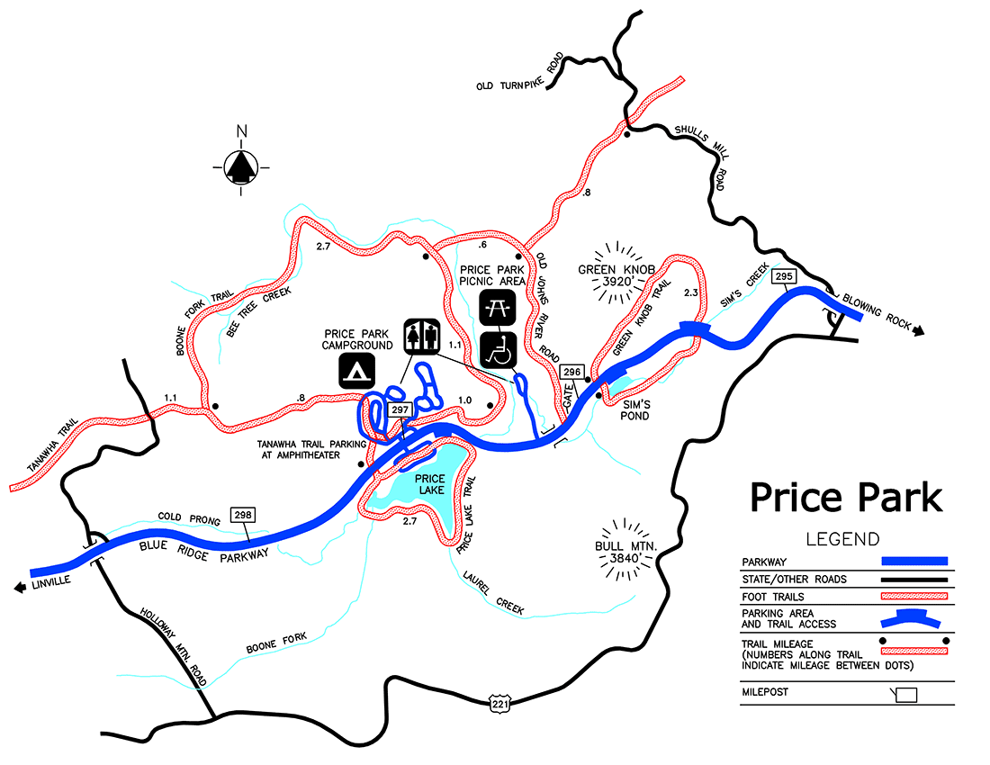
Green Knob Trail
This moderately strenuous 2.3-mile loop is diverse in scenery. Starting at Sim's Pond Parking Area, (milepost 295.9) the trail follows Sim's Creek through a section of dense rhododendron shaded by old growth timber. Several hemlocks measure more than 41 inches in diameter. A steady climb through pasture and wood leads to the top of green Knob, crowned on clear days with a distant view of Price Lake. The last section descends a steep hill with a view of Calloway Peak on the horizon.
Boone Fork Trail
Provides solitude in several environments–-clear streams, pastures, large rock out-crops, meadows, and shaded rhododendron-filled woods. Colorful wood ducks sometimes swim in Boone Fork creek. Allow at least 3 hours of daylight-walking time on this moderate to strenuous 5.5-mile loop trail. Access the trail at the wooden footbridge in Price Park Picnic area (milepost 296.4). TRACK Trail for first 1 mile.
The Mountains-to-Sea Trail
Marked with white blazes, the Mountains-to-Sea Trail runs jointly with the Boone Fork Trail for half its length. Signs indicate entry and exit points for the Mountains-to-Sea Trail.
Price Lake Trail
This trail can be reached from the Price Lake Overlook (milepost 296.7) or the Boone Fork Overlook (milepost 297.1). This easy 2.7-mile loop circles the shoreline of 47-acre Price Lake. Low-growing evergreens flourish year-round near the trail. Ducks and loons take a spring and summer pause here in their yearly migration. TRACK Trail for first 1 mile.
Tanawha Trail
The 13.5-mile Tanawha Trail leaves Boone Fork Trail near Price Park Campground. It meanders through field and forest in Price Park and parallels the Parkway on the flanks of Grandfather Mountain, ending at Beacon Heights (milepost 305.5). Parking and access for the Tanawha Trail in Price Park are available at the Boone Fork Overlook (milepost 297.1). See Tanawha Trail map for details.

|
Last updated: November 1, 2024
