
Craggy Gardens TrailThe Craggy Gardens Trail can be accessed from the south end of the visitor center parking area or from the north end of the picnic area. From the parking area, the trail begins as a self-guided nature trail with a moderate uphill climb for .3 mile to a large trail shelter. The self-guiding portion ends at the trail shelter, and a short spur trail to the left crosses the rhododendron bald to an unobstructed view of the town of Montreat and the lofty Black Mountain Range.
The main trail descends gradually from the shelter to enter a mixed-hardwood forest and in another .5 mile reaches the picnic area. Half-way from the shelter to the Picnic area a narrow loop path to the right leads to a small gazebo nestled in the forest and overlooking the valley below. Many wildflowers embellish the Craggy Gardens Trail from spring through fall, and blueberries on the bald offer an excellent late-summer treat.
. Douglas Falls TrailsAccess to the Douglas Falls Trails (also known as the Carter Creek Falls Trails) is via the Mountains-to-Sea Trail (MTS). From Graybeard Mountain Overlook, travel the MTS south for one mile to the intersection with the Falls Trail. Follow the falls trail three miles through a mixed hardwood forest to its termination at the falls. The trail winds past a series of cascades and two virgin hemlock groves before reaching the 70-foot Douglas Creek Falls. This strenuous, but rewarding 4-mile hike (8-mile round trip) has long been a favorite.
. Craggy Pinnacle TrailThis trail offers the most exceptional views for the least amount of walking. This moderate 20-minute walk begins from the upper level of the Craggy Dome Parking Overlook (just north of the tunnel that is in view from the visitor center). Visitors are rewarded with a breathtaking 360-degree view from its summit. Tunnels of rhododendron, gnarled sweet birch trees, and wildflowers abound from the trail's beginning to its crest. Here the heaths are mostly blueberries. A spur trail to the right, just before the summit, leads to an observation point surrounded by rugged, rocky terrain.
The Mountains-to-Sea Trail (MST)The MST stretches from Clingmans Dome in Great Smoky Mountains National Park to Jockeys Ridge State Park on the North Carolina coast. Here, it skirts the southern side of Craggy Pinnacle. Accesses to the MST are located at the south end of the visitor center parking area; at the north end of Craggy Gardens picnic area; and at Graybeard Mountain Overlook, located a mile north of the visitor center.The Snowball Mountain TrailA moderate to strenuous 8-mile round trip that affords beautiful views. Beware of poison ivy and stinging nettle bordering narrow portions of the trail. To reach the trailhead, start at the Mountains-to-Sea Trail crossing at the Picnic area road and continue south a few hundred feet. The Snowball Trail turns to the right (NW) off of the MTS Trail, passes through a mixed-hardwood forest and follows the ridges with views to both sides. Some heath areas are encountered as the trail continues up the main ridge over Snowball Mountain. From the second rock face, and 30 paces on a spur trail to the left, Hawkbill Rock provides good views of Reems Creek Valley to the west. After joining a rugged road and reaching a turn-around area, keep to the left-most road and continue to Little Snowball Mountain and remnants of a fire tower.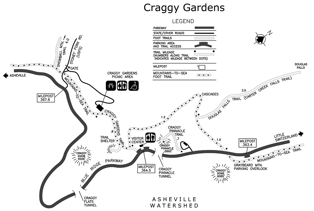
|
Last updated: November 1, 2024