
NPS/B. Trester The Lay of the LandThe chaotic appearance of this jumbled landscape presented substantial challenges to the first geologists who attempted to map the very complex geologic history of this area. It should be of little surprise to anyone that initial hypotheses explaining geological events here have been subjected to challenge and revision as the area has undergone continuous study. The geological history of Big Bend will continue to evolve as we make new discoveries and are able to more accurately piece together this magnificent story.Big Bend National Park has often been described as a “geologist’s paradise,” but it has also been called a “geologist’s nightmare.” The visitor can readily observe rock strata exposed at odd angles, standing vertical, or turned completely upside down. Rocks often appear to be completely displaced and do not “fit” within the areas in which they are found. Clearly there have been many geologic processes and forces at work over a vast expanse of time. This makes the interpretation of Big Bend's geologic history very difficult. Most of the visible surface of Big Bend National Park is relatively young when compared to the age of the Earth, which most geologists accept as being approximately 4.6 billion years. There are materials present that date from about 500 million years ago; however, most exposed rock throughout the park is 100 million years or less in age. 
NPS/C. Negele Early Mountain BuildingFrom 500 million years ago (mya) through approximately 300 million years ago the Big Bend area was near the western portion of a deep-ocean trough that extended from present-day Arkansas and Oklahoma to West Texas. From highlands in the north, eroded gravels, sand, and clay gradually accumulated in layers within this trough and, in time, became beds of sandstone and shale.About 300 mya pressure exerted by continental movement from the south forced these beds upward forming the Ouachita Mountains, the western roots of which extended to the northern part of Big Bend. Once thought to rival the elevation of the present day Rockies, about 160 million years of erosive forces have reduced the uplifted material. Worn remnants may be seen today to the north of the park, extending from the Marathon area to near Persimmon Gap in Big Bend National Park. Distinctive white bands of rock seen along Highway 385 to the north of the park represent beds that were tilted by the Ouachita mountain-building episode. Joined at birth with the Appalachian mountains to the east, the remnants of the Ouachita we see in this area were thus part of the first of several mountain building plate collisions that culminated in the construction of Pangea, the supercontinent that existed before each of the component continents moved to their current configuration. 
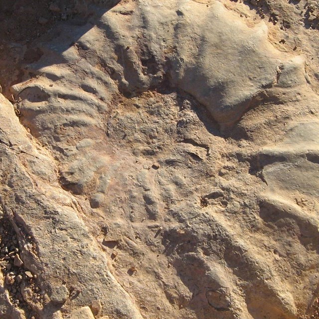
NPS/J. Jurado Shallow seas over Big BendIn many ways the Cretaceous Period (144-65 mya) is the beginning of our modern world. Flowering plants and pollinating insects both evolved during this period. Continental land masses moved closer to the positions and arrangements that we see today, and modern weather patterns began to be established. Perhaps the most obvious difference in the Cretaceous world was the wildlife, because this was the end of the Age of Reptiles, when dinosaurs, mosasaurs, crocodiles, and pterosaurs dominated the landscape.Around 135 mya, during the Cretaceous Period, the sea invaded the Big Bend area, as part of a vast, shallow seaway that divided the western portion of North America from the eastern portion. Cretaceous seas are thought to represent a high point in the evolution and abundance of calcium-rich organisms, the deaths of which resulted in deposition of thick lime muds that contain remains of sea-dwelling animals. Limestone layers that formed from these muds are highly visible in the vertical cliffs of the Sierra Del Carmen. Shallow sea sedimentary rocks, sandstone and shales, are seen in lowlands surrounding the Chisos Mountains and contain fossil remains of oysters, giant clams, ammonites, fishes, and marine reptiles. Near the end of the Cretaceous Period, a massive west-to-east compression of North America led to the second mountain building period in the Big Bend area. Progressing from north to south, ancient sediments at the compression boundary were forced upward to form the Rocky Mountains; the southernmost extension of the Rockies in the United States can be seen at Mariscal Mountain. Broad periods of uplift, punctuated by upward folding, exposed massive erosion-resistant early Cretaceous limestones along with less erosion-resistant sandstones and clays. The imposing limestone cliffs throughout Big Bend continue to be eroded as we view them today. 
NPS/B. Trester VolcanismRock of volcanic origin dominates much of the visual landscape in Big Bend National Park. The first of a series of volcanic eruptions occurred approximately 42 mya near the present northwest boundary of the park. Upward-moving magma lifted the area that is now the Christmas Mountains, and resulting fractures of surface strata allowed lava to spread in great sheets across the land.Between 38 and 32 mya a series of volcanic eruptions occurred within the park. Initial activity began in the appropriately named Sierra Quemada, meaning “burned mountain range” in Spanish, located below and south of the present South Rim of the Chisos Mountains. Volcanic activity that followed in the areas of Pine Canyon, Burro Mesa, and Castolon gave rise to colorful volcanic ash and layered lavas in lower park elevations and for most of the mass of the Chisos Mountains. Volcanic activity within the park was far from continuous and the thousands to millions-of-years intervals between periods of peak activity featured constant exposure of surfaces to the forces of erosion along with perpetual attempts by life forms to occupy areas as they became habitable. 
NPS/M. Schuler Vertical FaultingBeginning approximately 26 mya, the central area of Big Bend National Park was subjected to development of fracture zones as the continental plate that covers the western part of the US was stretched between the west coast and a point east of the park. Large blocks making up much of the central mass of the park between the Sierra Del Carmens on the east, and Mesa de Anguila on the west, dropped downward. This "sunken block" or graben, down-dropped several thousand feet by faulting, resulted in the disparity in height between the lower desert and the higher mountain ranges bordering the park to the south. Limestone layers at the base of both east and west ranges thus match layers found at the tops of the mountains!
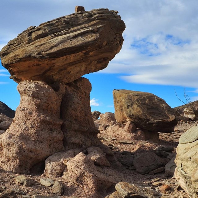
NPS/B. Trester ErosionMountain building by forces of compression, volcanism, and tension over a vast amount of time provided the foundation for present day Big Bend. The last 10 million years or so have been dominated by erosion sculpting the modern Big Bend landscape. As the highlands eroded, gravel and boulders formed a blanket of sediments around the base of the mountains. In the lowlands, sediments filled in the low places and erosion wore down the high places, forming a relatively flat, gently sloping surface called a pediment. Remnants of the pediment can be easily seen along park roads, for example, to the east of the Maverick Entrance Station.At first, the mountains were surrounded by closed basins, called bolsons. As the sediments filled the bolsons, the higher basins started to spill into the lower basins, creating drainage systems that became progressively larger as they linked to more basins. Eventually basins from El Paso to Big Bend became filled with eroded material, then linked by the Rio Grande. Within the last two million years, the Rio Grande has carved the magnificent canyons found within the park and throughout the entire river drainage. The Rio Grande is the youngest major river system in the United States and continues to serve as the principal erosional conduit in the region. 
NPS/B. Trester Present-day Big BendGeologic forces continue to shape the landscape of Big Bend. Today, weathering and erosion are the primary agents of change. Wind and water, often aided by suspended abrasive materials, minerals, or acids, have combined their efforts to produce the landscapes and features we enjoy today. One thing that is certain, as is demonstrated by the geologic history of the park, the Big Bend you see today just might be different next time you visit!
|
Last updated: February 13, 2025