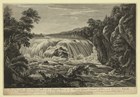
The Oneida Carry was the English name for the portage path between the Mohawk River and Wood Creek. The carry was a part of the major water route between New York City and Canada. It was between one to six miles in length depending on the season of the year.
-
Fort Stanwix National Monument
Article 1: A Timeline History of the Oneida Carry
The history of the Oneida Carry, an ancient portage trail, spans several centuries, countless historic events, and many different cultures. These are just a few of those connections. Read more
-
Fort Stanwix National Monument
Article 2: The Key to the Continent: Early Military History of the Oneida Carry
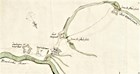
For centuries the Haudenosaunee people, including the Oneida Indian Nation, utilized a narrow strip of land situated between the Mohawk River and Wood Creek. It is here where the waters of the Mohawk flow east to Albany, the Hudson River, and New York City while those of Wood Creek flow west to Oneida Lake, Oswego, and Lake Ontario. The Oneida Carry was a land portage two to four miles wide that people could carry their canoes between the two waterways with relative ease. Read more
-
Fort Stanwix National Monument
Article 3: The Oneida Carry and Its Early Fortifications: 1755-1757
The Oneida Carry was the English name for the portage path between the Mohawk River and Wood Creek. The carry was a part of the major water route between New York City and Canada. It was between one to six miles in length depending on the season of the year. Read more
-
Fort Stanwix National Monument
Article 4: Fort Stanwix in the French & Indian (Seven Years) War: 1758-1760

While no battles ever took place in and around the Oneida Carry after Fort Stanwix was built, the fort and carry served as important travel and supply bases for British expeditions against the French in 1758, 1759, and 1760. Read more
-
Fort Stanwix National Monument
Article 5: Fort Schuyler (Stanwix) in the American Revolution: 1776-1781

Though Fort Stanwix was situated in New York, people from many states helped to rebuild and defend it during the American Revolution. Because of this the fort served not only as an important military post, but also as a place where people from 13 very different states began to forge a national identity. Read more
-
Fort Stanwix National Monument
Article 6: Early New York State Waterways & the Inland Lock & Navigation Company
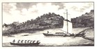
The Erie Canal was simply the last “technological update” to an already existing water route linking eastern and western NY. A series of waterways (Hudson River, Mohawk River, Wood Creek, Oneida Lake, Oswego River) served to link Albany with the Great Lakes region prior to the coming of the Erie Canal. Read more