Part of a series of articles titled The Oneida Carry.
Article
The Oneida Carry and Its Early Fortifications: 1755-1757

National Park Service
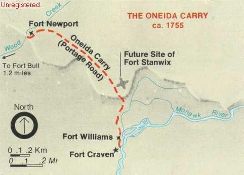
The Six Nations had used it long before any Europeans moved into the area. The carry took on new importance for the Six Nations as they became involved in fur trade. Furs were brought south to trade with the Dutch and English, and northeast to trade with the French. In exchange for the furs, European trade goods traveled west. The English began to exert a presence in the area of the carry as early as 1727, when they built a fortified trading post at Oswego. They later erected stockades on both ends of Oneida Lake. By the early 1750s the Oneida Carry had developed into an active station with two landings on each end; "upper landings" for high water and "lower landings" for the drier seasons. Indians and Europeans in the area made a business out of supplying wheeled transport to haul freight over the carry.

National Park Service
With the British having abandoned the carry, their western-most settlements were left exposed to French attack. In November of 1757, a large force of French, Canadian, and Indians raided and destroyed German Flatts. By the beginning of 1758, the French were making plans to send a large sweeping force down the Mohawk Valley to Albany. Only the threat of a British attack against their fort at Ticonderoga kept this from happening. With the French operations on the Mohawk frontier stalled, the British became determined to reoccupy the Oneida Carry and establish a strong outpost there.
By early summer a large British force was at the carry and on August 26, 1758 the construction of Fort Stanwix began. Fort Stanwix finally gave the British a dominant position over the Oneida Carry, a position that they would retain until the American Revolutionary War.

National Park Service
Visit our keyboard shortcuts docs for details
- Duration:
- 3 minutes, 57 seconds
Before Fort Stanwix was built in 1758, several forts guarded the Oneida Carry. Here is the story of one of them.
- Luzader, John F. Fort Stanwix: History, Historic Furnishings, and Historic Structure Reports. Washington: Office of Park Historic Preservation, National Park Service, U.S. Dept. of the Interior, 1976.
- Scott, John Albert. Fort Schuyler and Oriskany. Rome: Rome Sentinel Company, 1927.
- Watt, Gavin K. Rebellion in the Mohawk Valley: The St. Leger Expedition of 1777. Toronto: Dundurn Press, 2002.
- Willett, William M. A Narrative of the Military Actions of Colonel Marinus Willett, Taken Chiefly From His Own Manuscript. New York: G.C.H. Carvill, 1831.
Last updated: September 13, 2022
