Last updated: October 3, 2023
Article
Rivers and Borders on El Camino Real de los Tejas
Lacking major mountain ranges, Texas’ geography is shaped by its rivers. Rivers helped travelers determine distance, and they demarcated boundaries between Indigenous groups and, later, European and American settlers. Rivers were essential to Texans’ lives and livelihoods; they provided water for people and animals, irrigation for crops, and transportation between the coast and inland regions.
Indigenous Crossings
Caddo Mounds State Historic
Mission Tejas State Park
Caddo Mounds was a center of social and political life for a group of Caddoan people known as the Hasinai. Formed around Bowles Creek, this area offered resources – fresh water, fertile soil, and abundant natural foods – that allowed its residents to thrive.
When Europeans arrived, they attempted to establish trade relations with the Hasinai at a mission on San Pedro Creek. The mission acted as a sort of embassy between Spain and the Caddos at large. Spanish officials hoped that trade and diplomacy would prevent the Caddos from establishing relations with France. (At this point, French agents had established several trading posts east of the Mississippi River and had begun to explore the southern coast of Texas.)

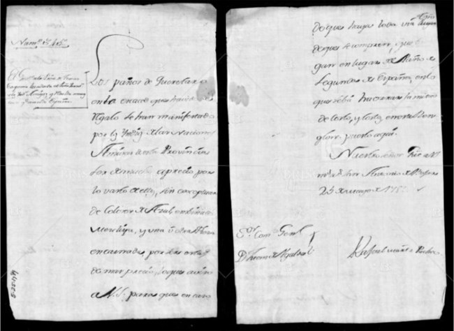
French traders in North America had a history of using commerce to build alliances with Indigenous nations. This letter from 1789—which asks that cloth be included in a shipment of gifts for Indigenous peoples—shows Spaniards attempting a similar strategy. Spanish governors in peripheral parts of the empire similarly relied on gifts and trade to maintain diplomatic and economic relationships with Indigenous populations, especially those courted by other empires. As European settlements and competition for imperial territory heated up in the late colonial period (roughly 1700–1821), the need to maintain these trade relationships became increasingly important.
Letter Translation
The cloth from Queretaro, with the scarcity of gifts, which has existed, has been said by the Indians of the friendly nations of this province, to be highly valued by the vast majority of them. This is without excluding the ones colored blue, wine, gray, and one or another piece of red, these being of greater cost. I advise your large ship of this, so that in case there might still be time to buy them, they might come instead of the Ponyo de Segunda, from Spain, whereby we will save half the cost and expenses on this item listed here.
Our Lord, keep your large ship many years, San Antonio de Behar, May 25, 1789. Lord commandment, General Don Juan de the gold.
Rafael Martinez, Puccio
C., 1–1 VPP., 525, 1789.

Image/Public Domain
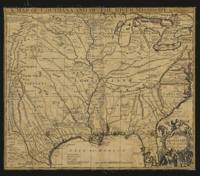
One of the earliest maps in the Texas State Archives is this French map from 1721, which shows the numerous river and creeks dividing southern Texas as well as larger waterways like the Missouri and Mississippi. Though the map shows El Camino Real de los Tejas running west to east clearly between the Rio Grande and Red rivers, the route is labeled for Louis Juchereau de St. Denis (‘Mr. S. Denis’)—a French trader who traveled to the Rio Grande in 1713, only to be imprisoned for carrying illegal merchandise into Spanish territory. The map also notes the location of La Salle’s 1685 expedition and the Spanish route used to find it. As this map attests, Texas played an important role in the colonial rivalry between France and Spain.
The map was originally drawn in 1718, the same year that the first missions were established in San Antonio. The presence of English, Spanish, and French words, along with the names of different Indigenous groups, hints at the competition for Texas during this period. While the coastal region labeled “Wandering Indians and Man-Eaters” might be shocking today, it is important to remember that, at the time the map was drawn, Indigenous peoples such as the Karankawa maintained control over these territories. Several European expeditions into the area ended in death and defeat.
Map Description
Map is bounded in the east by the Atlantic Ocean as far as Maryland, by the Gulf of Mexico in the south, the Great Lakes in the North, and in the west by the Rocky Mountains. Texas is shown as part of Louisiana. The Great Lakes and some of the rivers are slightly mislocated. Shown are bays, rivers, lakes, mountainous areas, colonies, territories, cities, towns, mines, forts, missions, routes and trails--including those of De Soto and La Salle, and Indian tribes and villages. The site of Fort Saint Louis and of La Salle's murder are noted. There are notes throughout the map regarding Indians, explorers, topography, and French and Spanish battles and establishments.
The Edges of Spanish Texas
Villa Antigua Border Heritage Museum
Mexico City was the center of Spanish administration in North America and the southern terminus of El Camino Real de los Tejas. Most Texas-bound travelers went overland via some form of the camino. The city of Laredo, along the banks of the Rio Grande, served as a resting and resupply point for those on their way to San Antonio. The river, in that time, was not the national border it is today. It was, instead, both a crucial source of water and the first major obstacle to reaching the interior of Spanish Texas. The size of the river and the danger of currents called for the establishment of camps on either side so that crossing could be attempted only in the best conditions. This can also easily be seen at [link to] Rio Grande Overlook at Arroyo San Francisco.
Fort St. Jean Baptiste State Historic Site
The first permanent French settlement in the Louisiana Territory, Fort Saint Jean Baptiste marked a border between European powers. On either side of the Red River, Spanish and French traders established missions and outposts to gain favor and, eventually, territory. The fort also sat on an Indigenous border. In 1731, Natchez warriors attacked Fort Saint Jean Baptiste while Caddos sent help to the besieged Frenchmen.

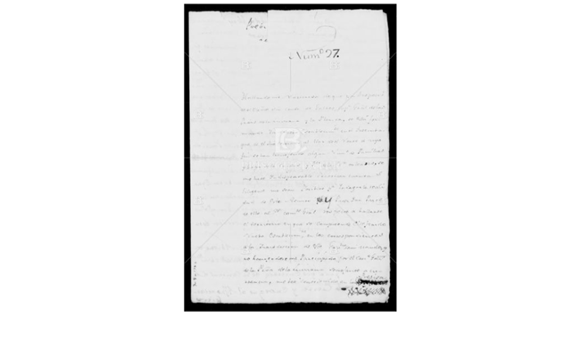
River mouths were especially important locations as they allowed access to Texas’ interior waterways. This 1785 letter from the governor of Texas to a presidial captain discusses rumors of a French settlement at the mouth of Texas’ Colorado River. Reacting to this alarming news, the governor recommends sending a reconnaissance party with a Jaraname guide from Mission Espíritu Santu, whose people were “once established” at the mouth of the Colorado. In using rivers to navigate and settle the Texas interior, European powers followed in the footsteps of Indigenous peoples who had followed and settled Texas’ river corridors for millenia.
Letter Translation
(Cross)
No. 27
I have been notified that on the decision of the most excellent señor Conde de Galvez, captain, general of the provinces of Louisiana, and Florida, a new settlement is being founded at the mouth of the Colorado river, on the northern sea, Gulf of Mexico, and that a number of families and troops from the city and port of New Orleans have moved to that destination. Thus it is essential for me to take whatever steps are possible, in order to investigate the truth of this matter, and to be able to report their on to the Lord commanded general, since the territory encompassing, the aforementioned new settlement is within the boundaries corresponding to the jurisdiction of this governor ship under my command , and since the governor of the province of Louisiana has not informed me of such an occurrence, I find myself with the strict obligation of seeking by every possible means the truth of this fact.
For the realization of this important matter and knowledge of the other circumstances, relating to it, I have decided to write to the commander who is in charge of the said settlement, so that, by this means, I may attain the object of my desire. And since for the successful transport of this letter, it is necessary to ensure its remittance, I have made provisions for Don Antonio de Messieres, with an able party of troops from your company, and if possible, some well equipped residence from your Presidio, to be carrier thereof. Consequently, your grace shell, without loss of time, arrange for this decision to be put into effect.
I am close for your grace and leave open the letter. I am writing to the aforementioned commander, so that, informed of its content, you may seal it, and deliver it to de Messieres, advising him to deliver it into the very hand of the said commander. You are to charge the party to attempt to behave with all due formality, and the troops traveling under his command, are to observe at the new settlement, the greatest possible subordination and good conduct.
Likewise, your grace is to advise that said officer, on his part, to observe with the greatest possible efficiency, all the circumstances of the new settlement, the number of its residence, and Garrison, which of the two sides of the mouth of the River the populous has occupied, whether they are fortifying it, and in what way, the condition of the Harbor, and what capacities of ships are able to dock there. Finally, he is to form a diary in such detail that with it, and with what the commander tells me, I may fully convey whatever is important for our commandment general to know on this matter.
I know quite well one route which de Messieres can take to travel from your Presidio to the new settlement, which is to cross the Guadalupe river by El Paso de el Pielago, which is 16 leagues away, and then follow along the head of the Arroyo of los Palomas, to the east, so that he will come out at the said mouth having traveled only 28 leagues. Never less, I find it appropriate for your grace to ask the padre of the mission of El Espíritu Santo for one of the Xaraname Indians thereof, to serve as their guide, since I know that all of them are very knowledgeable of the place, for they were established there. By this means, it will be possible to travel there without any detour, safe from the Carancahuases, who may be on the coast from beyond the Guadalupe river to the mouth of the Colorado.
When news of the aforesaid said new settlement is uncertain, steps, which are to be taken will suffice: he is to scout and cut across the land and inspect the coast of the northern sea. Gulf of Mexico, we’re for your grace shell advise de Messieres travel with all possible caution, since it is possible, that he may encounter some party of Carancahuases, whom it may be possible to punish as they deserve.
In spite of the pleasantries incivilities, in which the letter I am writing to the commander of the new settlement is couched, your Grace cell charge Alferes de Messieres to compliment the said officer on my behalf, and for his part to attempt to behave with the greatest possible harmony and good conduct, causing the same to be observed by all individuals in the party he fell under his command. And your grade she’ll take all possible care to recommend exact compliance here with.
As soon as the aforementioned officer returns from his assignment, your grace shall give me advice of all that has occurred, sending to me the letters he brings, and all the rest of what is relevant to that matter.
God keep your grace many years. Bexar, July 8, 1785.
Domingo Cabello
Señor, Don Luis Cazorla
(Cross)
From the mouth of the Colorado river to the Guadalupe, by El Paso de Pielego, is 28 leagues; from there to the Presidio of La Bahia, 16; into this, Presidio of Bexxar, 36; the total of which amounts to 80.
From the saidmouth to El Paso de El Governador, is 29 leagues; to the Arroyo of El Cibolo, 16; into this, Presidio, 18; the total of which is 63, going by the direct route.
From the Presidio of la Bahia, to go to the mouth of the Colorado, one goes by El Paso de El Pielago, then continues along the head of the Arroyo of los Palomas, and comes out directly upon the mouth.
The Island of La Culebra begins across from the harbor of Matagorda beyond the Presidio of La Bahia, and passes the mouth of the Colorado and the shore of El Sombrero.
The shores of Matagorda in El Sombrero are between the Guadalupe river and the Colorado.
The Harbor of la Bahia is where the ship which came from Veracruz was coming to disembark. That Harbor is called Matagorda at that part, which is furthest from the Guadalupe.

Copyright © Stanford University.
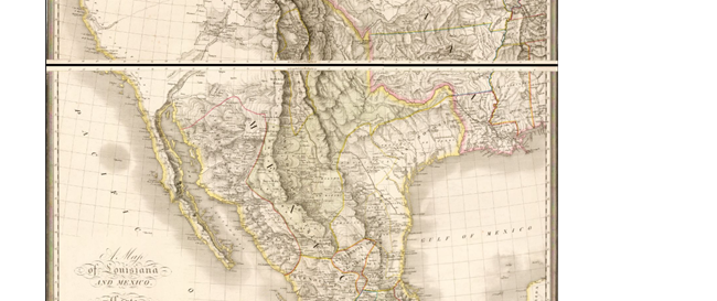
On this map of the US and Mexico made in 1820, Texas’ eastern boundary resembles the one we know today; on the western side, however, things look much different. Just west of San Antonio, the Provincia de Texas gives way to the Provincia de Coahuila (the Mexican constitution of 1824 would establish a joint state of Coahuila y Tejas). In 1830s, Texas won its independence from Mexico, claiming the Rio Grande as the border while Mexico insisted on the Nueces River, roughly 150 miles northeast of the Rio Grande. This disagreement continued after the United States annexed Texas in 1845. The area between the two rivers, known as the Nueces Strip, was crucial in igniting the Mexican American War (1846-48). It was not until the war’s end that the Rio Grande became the official border between Mexico and Texas.
Map Description
A portrait-oriented map with fine black lines on a white background, featuring occasional colored lines to mark political boundaries. The area covered ranges from present-day Canada in the north, southern Mexico to the south, the Pacific Ocean to the west, and the Mississippi River to the east. The map features relief to demonstrate elevation changes, and the prominent spine of the Rocky Mountains runs through the middle. The names of different settlements, Indigenous peoples, and geographic features are scattered throughout the map.
Smaller streams have played important roles in Texas history as well. McKinney Falls State Park includes a crossing of Onion Creek, a tributary of Texas’ Colorado River, used by many travelers along El Camino Real de los Tejas. The area’s clean water and lush setting attracted began attracting settlers in the 1850s. The subdivision of Onion Creek emerged in the 1970s, complete with a country club and golf course. Today, the upscale suburb is part the larger Austin metropolitan area.
Lacking obvious topographical features to guide them, travelers on El Camino Real de los Tejas relied on rivers to mark space. Though rivers could be dangerous crossing points, they later became the focal point of population growth. The construction of acequias by early Spanish settlers encouraged agriculture and settlement in the eighteenth century. Texas’ many small rivers provide fertile ground for farming, which drew many people to the area. Fresh water and good soil allowed for the development of large-scale agriculture in Texas, encouraging Anglo American settlement during the brief era of Mexican administration. Texas’ waterways also acted as navigation tools for cowboys pushing cattle north to the railroad lines in Kansas City and then returning home.
Rivers continue to provide water, wildlife habitat, and recreational opportunities across Texas. They remind us not only of the centrality of water to human settlement but also of the need for preserving our environment for future generations.
(Special thanks to UNM PhD candidate Meghann Chavez for compiling this information)
