Last updated: May 9, 2025
Article
Vegetation Monitoring at Big Thicket National Preserve: Results for 2022

Photo by NPS /Jane E. Carlson
Overview
Throughout the National Park Service, plant communities and other key natural resources are monitored as indicators of environmental health by a nationwide program of 32 Inventory and Monitoring (I&M) Networks. The Gulf Coast I&M Network covers eight National Park Service (NPS) parks in the southeastern U.S. and Texas. The network's terrestrial vegetation monitoring program is carried out in all eight parks, with the goal of measuring the health and condition of key plant communities repeatedly over time. Specific objectives include documenting status and change in (1) richness of native and non-native species; (2) percent cover and frequency of key species or growth forms (e.g., grasses or shrubs); and (3) the health and regeneration of forests. The network's vegetation monitoring program follows a published protocol that is largely consistent with other I&M networks in the eastern U.S. The Gulf Coast I&M Network conducts vegetation monitoring fieldwork once every four years in each park.
Highlights
• The NPS Inventory and Monitoring program completed its first round of vegetation monitoring in Big Thicket National Preserve in summer 2022. The 60 long-term plots captured a surprisingly varied and complete set of the low-elevation forest types in the Gulf Coastal Plain's western extent, all packed into a relatively small area in southeastern Texas.• Most long-term plots represented fairly common communities for Big Thicket that were also widespread in the southeastern or south central plains ecoregions. However, several plots were in the rare communities of baygalls or wet flatwoods, which are more narrowly restricted within southeastern Texas and western Louisiana. Monitoring these plots will allow for closer study of these unusual types of wetlands.
• Four of the 60 I&M plots were specifically placed in areas of current or future restoration in upland or wet longleaf pine savannas. These plots will allow tracking of progress and impacts of management activities in these rich and highly valued areas of the Preserve.
This article presents a brief project overview and key findings from the first round of I&M vegetation monitoring in Big Thicket National Preserve, conducted in 2022. The full summary for 2022 provides more in-depth descriptions of the study area, methods, species lists and richness, patterns in understory species dominance, and results for forest health and regeneration. All current and past reports, as well as raw data exports, can be found through the online project repository.
Study Area
Big Thicket National Preserve consists of over 44,000 hectares (108,726 acres) of protected lands and waters in southeast Texas. The Preserve is centered on the Neches River and its tributaries, and it consists of nine units and several connecting riparian corridors. The Gulf Coast I&M Network conducts long-term vegetation monitoring on five of the major units: Beech Creek, Big Sandy, Jack Gore Baygall, Lance Rosier, and Turkey Creek. These five units span three different counties in Texas, three different U.S. EPA Level IV Ecoregions, and range in elevation from 8 - 97 meters [m] (26-318 feet) above sea level (Figure 1). The lowest elevations within the context of this project are Lance Rosier in the southwest and Jack Gore Baygall along the Neches River to the east. These two units feature the Preserve’s largest expanses of bottomland forests, swamps, and other forested wetlands. Turkey Creek, which is a relatively narrow unit running north-south in the center of the Preserve’s extent, has the widest range in elevations, landforms, and forest types. The two units in the north, Big Sandy and Beech Creek, encompass higher elevations than the other units, but forested wetlands are still abundant along streams and other low-lying areas.
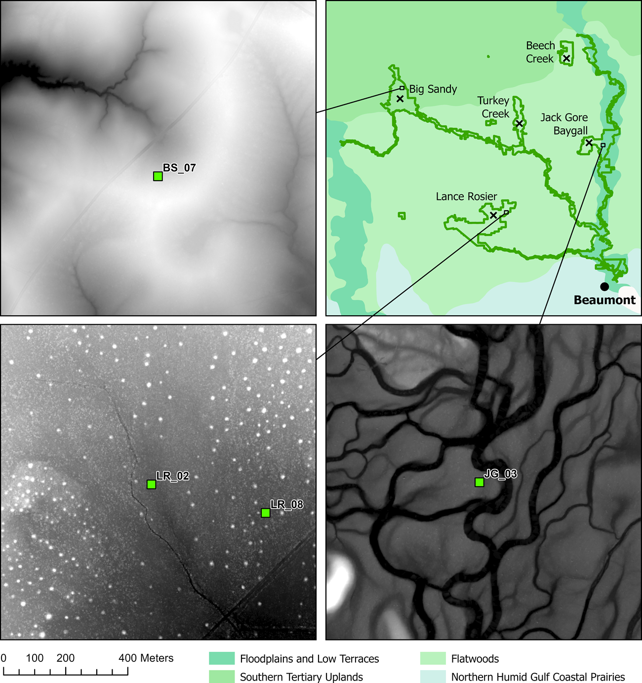
Diversity in landform, even with relatively little elevational change, helps explain the large number of plant communities in the Preserve.
Across the five units and the varying landforms within them, the Preserve hosts a wide range of plant communities. These communities include many of the characteristically southeastern forest types at or near their western-most extent, as well as a few species of dry, open communities more common to the west. Within the Big Thicket region, many of these native communites are restricted to a patchwork of protected lands, which are surrounded by residental areas, forestry plantations, oil and gas industry, cropland, or pastureland. As such, the Preserve's list of species of conservation concern is long, including several endemic and near-endemic species. Many of these species are found on sandy soils with a sparse overstory dominated by pines, which were historically mostly longleaf pine (Pinus palustris). Indeed, the longleaf pine uplands and wet savannas of the southeast are well known for their unusually high richness and endemism in the understory, a fact that helped motivate the North American Coastal Plain’s recent designation as the 36th global biodiversity hotspot (Noss et al. 2015).
Fire is a key process for maintaining several of the Preserve's plant communities, including those with a high proportion of species of conservation concern. Without fire, native hardwood trees and shrubs can encroach into the open pine woodlands and outcompete the understory grasses and wildflowers (see also Streng and Harcombe 1982, Harcombe et al. 1993, Watson 2006). Restoring longleaf pine communities is a core management goal within the Preserve, and the main restoration methods include frequent prescribed burns (every 2-3 years), overstory tree thinning, chemical or mechanical removal of woody plants, and planting of longleaf pine. Through a mix of these activities, the park maintains several areas with longleaf pine overstories and/or the rich, herbaceous understory communities. One example is an area near the Visitor Center, called the Solo Tract, which recieved its first prescribed burn in early 2022, following several rounds of woody plant removal in the preceding years (Figure 2). The park aims to restore even more pine-dominated habitat for the federally protected red cockaded woodpecker (Leuconotopicus borealis), which has been absent from the park since 1995 (Conner et al. 2006).
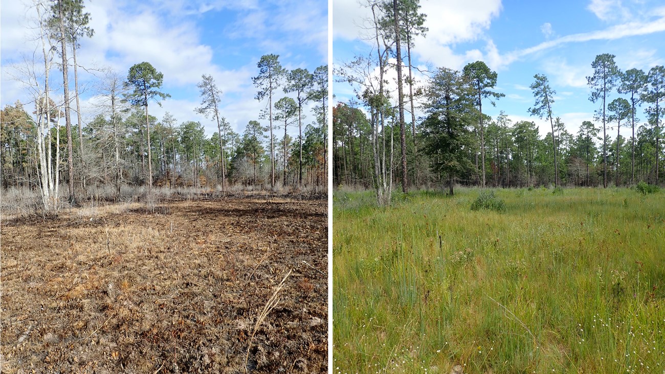
NPS/GULN
Methods
The Gulf Coast I&M Network documents status and change in vegetation communities using repeat-sampling within 400 meter2 [m] plots that are distributed throughout entire parks or targeted park units. At Big Thicket National Preserve, there are 56 primary plots and four targeted plots within five focal units: Beech Creek (10 primary plots), Big Sandy (12 primary and 1 targeted), Jack Gore Baygall (10 primary plots), Lance Rosier (12 primary and 1 targeted), and Turkey Creek (12 primary and 2 targeted). The primary plots were selected as a random draw within entire units or major portions of units, and the targeted plots were placed specifically within four current or potential longleaf pine restoration areas. All 60 plots were first visited during winter months between Dec. 2019 and Feb. 2022 to install plot markers and tag trees, requiring a diameter at breast height [DBH] of ≥10 centimeters [cm] for tagging. Crews returned to sample plots during the growing season of 2022, following the methods published in the protocol “Monitoring Terrestrial Vegetation in Gulf Coast Network Parks”, and its 11 standard operating procedure documents (Carlson et al. 2018). In short, all plant species were identified in each 400 m2 ( 20 x 20 m) plot, and their coverages and relative frequencies were recorded in nested sampling frames as metrics of understory dominance. New tree recruits were tagged, i.e., those reaching ≥10 cm DBH since plot establishment, and then all newly and previously tagged trees were measured for DBH and assessed for damage. Juvenile trees were counted within four 10-m2 microplots per full plot, divided into classes of seedlings (heights up to 1.36 m) and saplings (heights taller than 1.36 m and DBH <10 cm). These data served as a baseline for tracking forest health, including tree growth, recruitment, and mortality.
Key Findings
Vegetation Communities Sampled
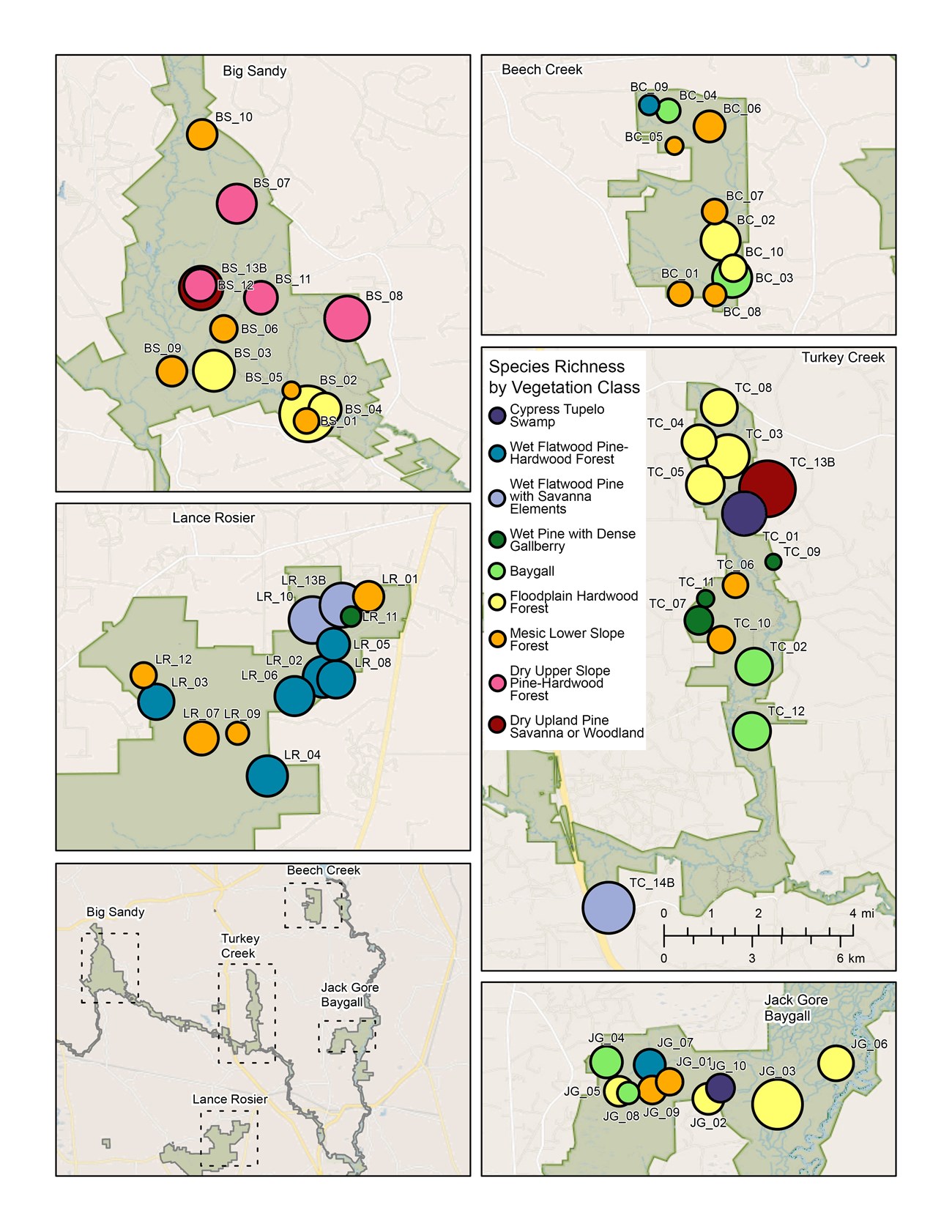
The 60 long-term plots in this study belonged to nine vegetation classes, based on the Preserve's original vegetation classification work by Paul Harcombe and Peter Marks (Harcombe and Marks 1979; Marks and Harcombe 1981). These nine classes encompassed a wide range of forest tree assemblages, understory assemblages, soil moisture regimes, and soil types. Most classes were also fairly widely distributed across the Preserve, with between 4 and 7 vegetation classes in each unit (Figure 3). Five of the classes were types of wetlands, representing 38% of the randomly-selected plots (21 of 56). To help characterize differences among classes, brief descriptions are provided below, beginning with classes on the lowest landscape positions with frequent to permanent inundation and ending with those in well-drained uplands. Detailed descriptions of each class are in Appendix C of the main report.
The Cypress-Tupelo Swamp class (2 plots) represented communities with soils that were saturated on a nearly permanent basis and a canopy dominated by bald cypress (Taxodium distichum) and water tupelo (Nyssa aquatica). The Wet Flatwood Pine-Hardwood Forest class (8 plots) represented several flood-prone communities on broad, mainly flat, low elevation areas away from current major drainages. Mima mounds, also called pimple mounds, were often a prominent feature of this class, particularly in Lance Rosier (see Figure 1). These mounds featured loblolly pine (Pinus taeda) and other species that were not quite as tolerant of flooding as those in the surrounding flats. The Wet Flatwood Pine with Savanna Elements [Wet Flatwood Pine] class (1 primary plot; 2 targeted plots) represented a relatively rare community on low to mid elevations within the Preserve that also had poor drainage. These communities featured saturated or inundated soils in winter and drought-prone soils in summer and fall, due to the low permeability of sodic soils or shallow clay layers. The pine-dominated canopy (loblolly or longleaf) was typically sparse, and the understory was rich and herbaceous. The Wet Pine with Dense Gallberry class (4 plots) was related to the previous class in that it occupied mid-level landscape positions with poor soil drainage and an overstory of longleaf or loblolly pine. A major difference, however, was the extremely thick gallberry (Ilex coriacea), which was presumably favored by relatively high and constant soil moisture and a lack of fire. The Baygall class (6 plots) represented several types of acidic wetland communities occurring in shallow drainages within most forested community types except the major river floodplains. A defining feature was a thick layer of gallberry, Swamp titi (Cyrilla racemiflora) and other shrub species, all below a canopy of sweetbay magnolia (Magnolia virginiana) and swamp tupelo (Nyssa biflora). The Floodplain Hardwood Forest class (13 plots) represented communities with a fairly rich assemblage of canopy tree species, all able to withstand occasional flooding, on flat expanses near streams and rivers. The presence of ironwood (Carpinus carolinensis) and/or cow oak (Quercus michauxii) with a relatively sparse understory were defining features of the class. The Mesic Lower Slope Forest class (18 plots) represented a range of communities on shallow to steep slopes that were dominated by hardwoods or by a combination of hardwoods and loblolly pine. Forests of beech and magnolia were included in this class. The Dry Upper Slope Pine-Hardwood class (4 plots) represented forests of pines and hardwoods on sandy loam soils of upland slopes. Characteristic trees were shortleaf pine (Pinus echinata), loblolly pine, and several oak species, including post oak (Quercus stellata) and southern red oak (Quercus falcata). The understory generally had extremely dense yaupon (Ilex vomitoria). Finally, the Dry Upland Pine Savanna or Woodland [Dry Upland Pine] class (2 targeted plots) represented pine-dominated communities (longleaf, loblolly, or shortleaf pine) with relatively few hardwoods and an understory that can be savanna-like if frequently burned.
Preserve-Wide Richness Summaries and Notable Species
Across all 56 primary plots sampled in 2022, I&M staff recorded 367 plant taxa. The four targeted plots contributed 78 additional taxa, for a cumulative total of 445. The most species-rich growth form was forbs (i.e., herbaceous, non-graminoid angiosperms plus ferns), with 202 taxa or 45% of the total. Graminoids (grasses, sedges, and rushes) were second most rich (111), followed by trees (60), shrubs (41), then vines (31). Among these richness totals, the most remarkable was for trees, as it placed Big Thicket among the top tier of park-level tree richness in I&M plots throughout all sampled National Park units in the eastern U.S. Although no rare species (i.e., on state or federal lists) were recorded during monitoring, several plots were within communities listed as rare by Texas Parks and Wildlife Department or as Vulnerable or Imperiled by Natureserve. These rare communities were represented by several plots within the following four classes: Baygall, Wet Flatwood Pine-Hardwood, Wet Flatwood Pine, and Dry Upland Pine.
The most widely recorded species overall was American holly (Ilex opaca), found in 94% of the primary plots. Four additional native species were nearly as widespread, in 82-86% of primary plots: sweetgum (Liquidambar styraciflua), loblolly pine, water oak (Quercus nigra), and yaupon. The most widespread species among forbs, vines, and graminoids were cat greenbriar (Smilax glauca), muscadine (Vitis rotundifolia), and partridgeberry (Mitchella repens), all present in 79-80% of primary plots. These eight widespread species were present in some of the targeted plots as well; see the main report for more details in addition to the full list of species lists from 2022 vegetation monitoring.
There were 10 non-native species recorded in plots, with only one species, Chinese tallow (Triadica sebifera), being fairly widespread, in 55% of primary plots. The next most frequently recorded non-native was Japanese climbing fern (Lygodium japonicum), present in 30% of primary plots, followed by Chinese privet (Ligustrum sinense) in 14% of primary plots. Overall, at least one non-native species was present in 68% of primary plots. Even though non-natives were often recorded as present, they were never recorded at higher than 5% cover in the understory.
Richness Summaries Per Plot and by Vegetation Class
The Preserve’s richest vegetation classes were Dry Upland Pine (71 species per plot; max of 81) and Wet Flatwood Pine (67 species per plot; max of 73; Figure 4; Table 1). Both classes were central to the Preserve’s longleaf pine restoration efforts and had been specifically targeted with two nonrandom I&M plots each. As expected, both classes had some longleaf pine in the overstory, and both were unusually rich in forbs and graminoids. A few of the characteristic understory species of each class are shown in Figure 4A-C for Dry Upland Pine and Figure 4D-F for Wet Flatwood Pine. Three of the five plots in either class were located in focal management areas for the Preserve. These were portions of Turkey Creek or Big Sandy that received regular prescribed burns and occasionally, additional treatment such as removal of woody plants and planting of longleaf pine seedling and native grasses. The remaining two plots were in the northeast corner of Lance Rosier unit, which houses the Preserve's largest tract of Wet Flatwood Pine. Prescribed fire has not been applied to that area within the last decade, but increased restoration activity is under consideration. This class’s partial resilience to fire suppression is in contrast with that of the Dry Upland Pine, Dry Upper Slope Pine-Hardwood, and Wet Pine with Dense Gallberry classes, which are dominated by yaupon, gallberry or other woody plants in the absence of frequent fires.
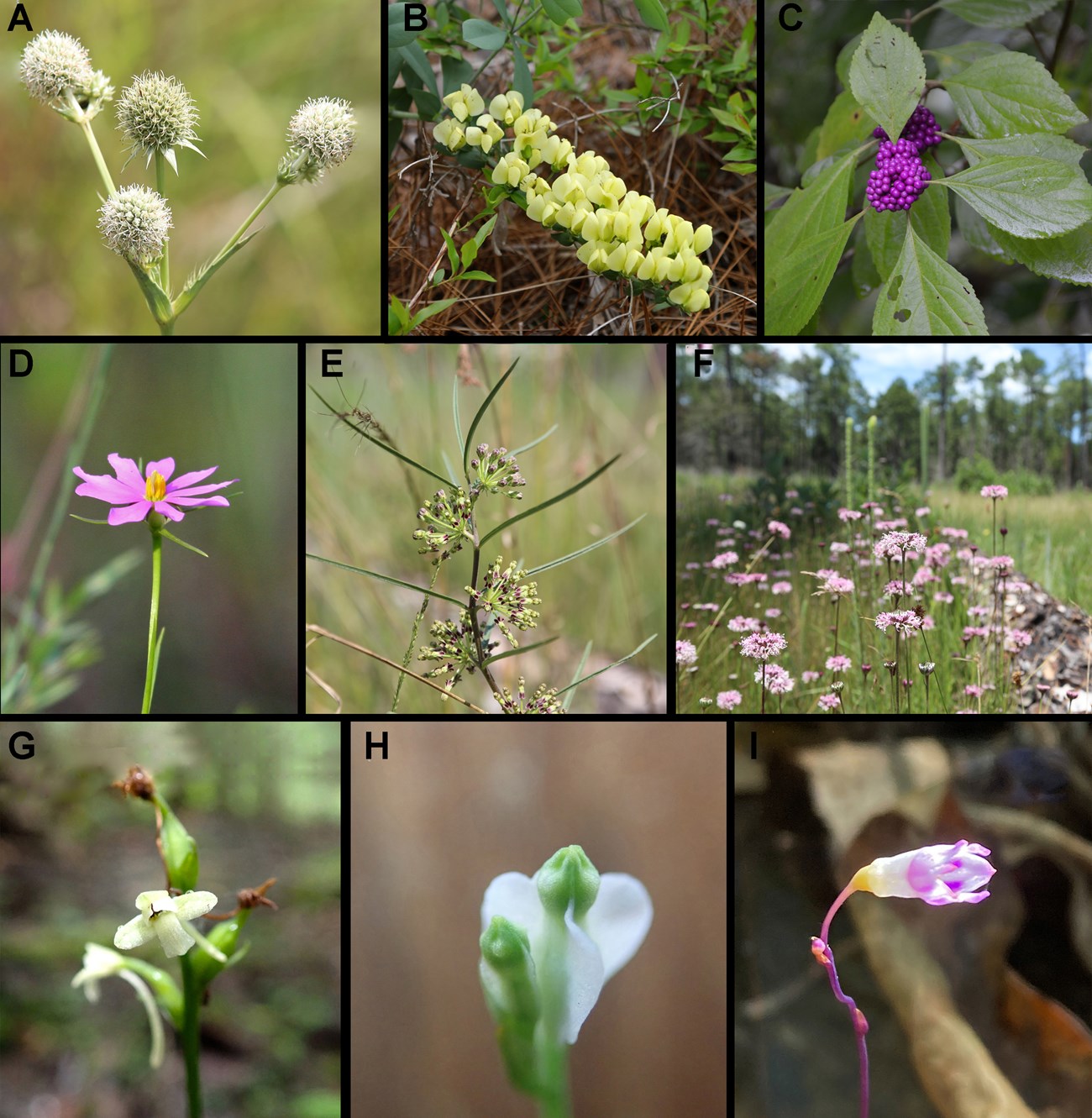
GULN/NPS
Table 1. Mean plant species richness per plot in 2022, summarized for each of the nine broad vegetation classes at Big Thicket National Preserve. Species counts include all species recorded in each plot, whether they are rooted in, overhanging, or prostrated across the plot. All 60 plots are summarized, which includes 4 targeted, non-randomly selected plots. Mean Species Richness includes unidentified species with unknown nativity status.
| Broad Vegetation Class (Number of Plots) | Mean Species Richness (Min-Max) |
Mean Non-Native Species Richness (Min-Max) |
Mean Species Richness of Trees (Min-Max) |
| Cypress Tupelo Swamp (2) | 49 (36-61) | 5 (1-8) | 12 (11-12) |
| Wet Flatwood Pine-Hardwood Forest (8) | 47 (23-57) | 1 (1-2) | 14 (9-18) |
| Wet Flatwood Pine with Savanna Elements (3) | 67 (61-73) | 0 (0-1) | 9 (5-13) |
| Wet Pine with Dense Gallberry (4) | 23 (16-36) | 0 (0-0) | 9 (6-12) |
| Baygall (6) | 42 (26-54) | 1 (0-1) | 12 (9-15) |
| Floodplain Hardwood Forest (13) | 52 (34-80) | 2 (1-4) | 18 (14-24) |
| Mesic Lower Slope Forest (18) | 33 (19-45) | 0 (0-2) | 15 (10-18) |
| Dry Upper Slope Pine-Hardwood Forest (4) | 51 (43-63) | 1 (0-2) | 20 (16-25) |
| Dry Upland Pine Savanna or Woodland (2) | 71(61-81) | 1 (0-1) | 11 (10-12) |
| Overall (60) | 44 (19-81) | 1 (0-8) | 14 (5-25) |
Species richness was lower in the remaining seven vegetation classes, but several classes were still fairly rich. For example, Dry Upper Slope Pine-Hardwood Forest had 52 species per plot, and Floodplain Hardwood Forest had 51, which were both well above the Preserve-wide average of 42 (Table 1). Both classes were particularly rich in trees, with per-plot averages of 18 or 20 species and a maximum of 24 or 25. The Baygall class was notable for its relatively high shrub richness and for the presence of several minute forbs species that can only be found in baygalls or similar acidic wetland habitats (examples in Figure 4G-I). The most species-poor classes were Wet Pine with Dense Gallberry (23 species) and Mesic Lower Slope Forest (33 species), with the latter being the most common class in the monitored units of the Preserve.
Percent Cover and Relative Frequency in the Understory
Each vegetation class featured a fairly distinct group of dominant species in the forest understory, as measured by percent cover and relative frequency in understory microplots. For two of the vegetation classes, the understories were dominated by a single shrub species with >50% cover. These were Wet Pine with Dense Gallberry class, which was dominated by gallberry (Ilex coriacea; 54% cover), and Dry Upper Slope Pine-Hardwood Forest, which was dominated by yaupon (54% cover). The Baygall class also achieved >50% cover when the top two shrub species were combined: swamp titi (40% cover) and gallberry (30% cover). For the remaining six classes, understory vegetative cover was lower on average, but there was notable variation among plots, particularly within the mesic lower slope and wet flatwood pine-hardwood classes.
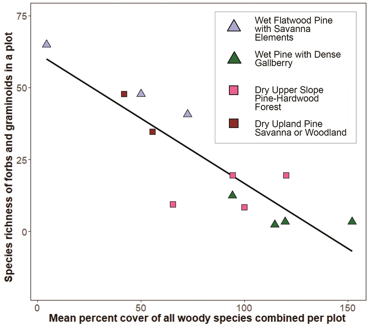
Plots with dense, nearly impenetrable understories were examples of the 'thickness' after which Big Thicket was named. For a few vegetation classes in this study, dense understories were consistent with a reference or 'natural' condition for the site (e.g., Baygalls), but for the fire-adapted communities, they generally were not. In those communities, dense, woody understories were linked to an absence of the rich herbaceous layers that were expected in fully restored longleaf pine habitats. This trade-off was detected as a negative association between herbaceous species richness and woody plant percent cover (combined for all woody species <5 m in height within microplots; excluding vines) across the four fire-adapted vegetation classes: Wet Flatwood Pine, Wet Pine with Dense Gallberry, Dry Upper Slope Pine-Hardwood, and Dry Upland Pine (Figure 5). Among the plots in this group, one stood out for having both extremely low woody cover (4%) and notably high richness in forbs and graminoids (65 total). This was the Solo Tract plot, which had the most recent restoration work of any plot in the I&M sample, including prescribed fire in early 2022 and repeated woody plant removal over the last several years (Figure 2). These findings showcase the potential gains of restoration efforts that include both frequent fires and thinning or clearing of woody plant species, activities that are currently underway in several parts of the Preserve.
Tree and Regeneration Metrics
Forest health metrics were collected in all 60 plots, with each plot having between 1 and 51 live trees (1,423 total) and between 1 and 221 juvenile trees (2,963 total). Mean stem density was 593 stems per hectare or 24 stems per plot, and mean DBH per plot was 22.3 cm. Relative to other forest-dominated parks in the Gulf Coast Network, Big Thicket had more trees per plot that were on average smaller in diameter. Tree size, density and composition varied widely among vegetation classes (Table 2; for differences among units, see main report). The Cypress Tupelo Swamp class stood out as having the highest mean basal area, highest stem density, and second highest DBH. Mean basal area and stem density were also notably high for the Mesic Lower Slope, Floodplain Hardwood, and Wet Flatwood Pine-Hardwood Forest classes. Floodplain Hardwood plots contained the Preserve’s highest three DBH values for individual trees, with the largest being a cow oak with a DBH of 100.5 cm in one of the Turkey Creek plots.
Table 2. Mean tree and regeneration metrics for plots within each vegetation class from 2022 sampling in Big Thicket National Preserve. Adult tree data were collected for all trees ≥10cm DBH in the 400-m2 plot, and regeneration data (juvenile densities) were collected in four 10-m2 microplots in each plot. Total juvenile densities were based on the sum of seedling and sapling classes, excluding recent germinants. All 60 plots, including the four targeted plots, were included in the summaries.
| Broad Vegetation Class (Number of Plots) | Basal Area (m2/ha) | Live Tree Stems /ha | DBH (cm) | Total Juvenile Tree Density /m2 | Top three tree species by stem counts |
| Cypress Tupelo Swamp (2) | 72.7 | 988 | 28.2 | 0.19 | Nyssa biflora,Taxodium distichum,Nyssa aquatica |
| Wet Flatwood Pine-Hardwood Forest (8) | 29.3 | 794 | 20.0 | 0.68 | Nyssa biflora, Pinus taeda, Quercus laurifolia |
| Wet Flatwood Pine with Savanna Elements (3) | 9.8 | 350 | 19.5 | 0.53 | Pinus taeda, Quercus nigra, Nyssa biflora |
| Wet Pine with Dense Gallberry (4) | 21.1 | 506 | 19.2 | 0.70 | Pinus taeda, Cyrilla racemiflora, Ilex opaca |
| Baygall (6) | 19.1 | 542 | 19.8 | 0.43 | Cyrilla racemiflora, Nyssa biflora, Magnolia virginiana |
| Floodplain Hardwood Forest (13) | 27.7 | 646 | 20.2 | 0.55 | Quercus nigra, Ilex opaca, Carpinus caroliniana |
| Mesic Lower Slope Forest (18) | 28.7 | 556 | 22.9 | 0.56 | Pinus taeda, Ilex opaca, Nyssa sylvatica |
| Dry Upper Slope Pine-Hardwood Forest (4) | 24.2 | 488 | 22.9 | 0.56 | Quercus stellata, Pinus taeda, Pinus echinata |
| Dry Upland Pine Savanna or Woodland (2) | 26.4 | 288 | 35.9 | 1.30 | Pinus palustris |
| Overall (60) | 27.2 | 593 | 21.8 | 0.58 | Pinus taeda, Ilex opaca, Nyssa biflora |
Comparison of regeneration metrics revealed a mix of juvenile taxa in the understories of most sampled forest types, with the dominant species often differing between juvenile and adult cohorts. One taxon was notably abundant as juveniles but exceedingly rare as adults. The Preserve's two bay species (Persea spp.) were represented by just one live adult as compared to 327 juveniles, providing strong evidence that laurel wilt was impacting the Preserve. This fungal disease, transferred between trees by the invasive redbay ambrosia beetle, was first recorded in Hardin and Jasper counties in 2015. Longleaf pine was another species of particular interest in terms of regeneration. Across the 56 primary plots, longleaf pine was recorded in only two plots. One plot in the Wet Flatwood class had a single adult, and a second plot in the Wet Pine with Dense Gallberry class had six adults and one juvenile. Based on class descriptions, this species was also expected in Dry Upland Pine (it was present in the targeted plots), and to a lesser extent, Dry Upper Slope Pine-Hardwood (it was not present). The four nonrandom plots were selected to ensure samples of longleaf pine communities, and those plots increased the total adult count by 25 and the total juvenile count by 12. Even so, eight of those juveniles were in plots that had previously been planted with longleaf pine seedlings, suggesting that there is limited natural regeneration of this species within the Preserve. The detection of live longleaf seedlings in restoration areas nevertheless provided evidence of successful establishment, and their continued growth and survival can now be tracked over time.
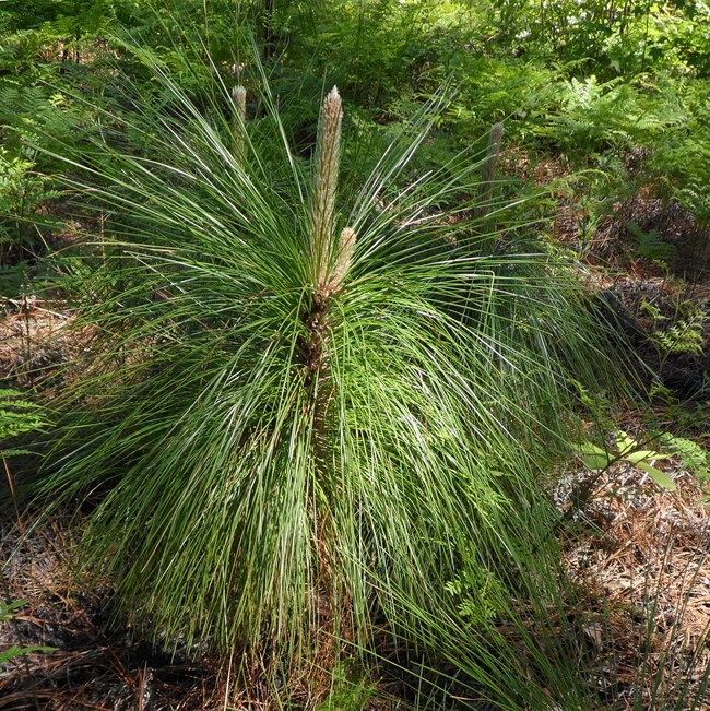
Juvenile longleaf pine tree. Image credit: Carolyn Carlson
Conclusions
Overall, the first round of I&M vegetation monitoring on the Preserve supported the concept that the Big Thicket contains many of the diverse forest types known from low elevations in the southeastern United States, especially those west of the Mississippi River, all packed into a relatively small area in southeastern Texas. Although the dominant vegetation classes themselves were not particularly rich or rare for the southeast, several of the wetland types were restricted to southeastern Texas and western Louisiana, including specific plant associations within Baygalls, Wet Flatwood Hardwoods, or Wet Flatwood Pine. As this is the first round of data collection in a long-term study, in-depth interpretation of patterns will benefit from additional rounds of data collection. The next vegetation monitoring event in the Preserve is scheduled for summer 2026, and subsequent events will continue once every four years.
Literature Cited
Carlson, J. E., J. Bracewell, W. Granger, and M. Segura. 2018. Monitoring vegetation in Gulf Coast Network parks: Protocol implementation plan. Natural Resource Report NPS/GULN/NRR—2018/1746. National Park Service, Fort Collins, Colorado.
Conner, R.N., D. Saenz, and D.C. Rudolph. 2006. Population trends of red-cockaded woodpeckers in Texas. Bull. Texas. Ornith. Soc. 39 (2):42-48.
Harcombe, P.A., J.S. Glitzenstein, R.G. Knox, S.L. Orzell, and E.L. Bridges. 1993. Vegetation of the longleaf pine region of the West Gulf Coastal Plain. Proc. Ann. Tall Timbers Fire Ecol. Conf. 18:83-103.
Harcombe, P.A., and P.L. Marks. 1979. Forest vegetation of the Big Thicket National Preserve. Unpublished report: U.S. Park Service, Santa Fe, New Mexico. https://irma.nps.gov/DataStore/Reference/Profile/50109
Ley, M., T. Baldvins, H. Pilkington, D. Jones and K. Anderson. 2024. Vegetation classification and mapping project: Big Thicket National Preserve. Natural Resource Report NPS/BITH/NRR—2024/2621. National Park Service, Fort Collins, Colorado.
Marks, P.L. and P.A. Harcombe. 1981. Forest vegetation of the Big Thicket, southeast Texas. Ecological Monographs 51:287-305.
Streng, D.R., and P.A. Harcombe. 1982. Why don’t East Texas savannas grow up to forest? The American Midland Naturalist 108: 278-294.
Watson, G.E. 2006. Big Thicket plant ecology: an introduction, third edition. University of North Texas Press, Denton, Texas.
Wiedenfeld, J. 2006. Soil Survey of Hardin County, Texas. U.S. Department of Agriculture, Natural Resources Conservation Service. 346 pp.
Other Reports, Briefs, and Summaries in this Series
Carlson JE and Bracewell J. 2025. Vegetation Monitoring at Palo Alto Battlefield National Historical Park: Results for 2023. Gulf Coast I&M Network, Lafayette, LA. Web article and Datastore reference with pdf print-out and Supplementary Materials.
Carlson JE. 2025. Vegetation Monitoring at San Antonio Missions National Historical Park: Results for 2023. Gulf Coast I&M Network, Lafayette, LA. Web article and Datastore reference with pdf print-out and Supplementary Materials.
Carlson JE. 2023. Vegetation Monitoring at Natchez Trace Parkway: Results for 2021. Gulf Coast I&M Network, Lafayette, LA. Full summary in the Datastore and web article.
Carlson JE. 2022. Vegetation Monitoring at Barataria Preserve, Louisiana: 2021 Trip Report and Brief. Gulf Coast I&M Network, Lafayette, LA. Web article summary
Carlson JE. 2020. Trip Report for Vegetation Monitoring at Padre Island NS 2019. Gulf Coast I&M Network, Lafayette, LA
Carlson JE. 2020. Trip Report for Vegetation Monitoring at Palo Alto Battlefield NHP 2019. Gulf Coast I&M Network, Lafayette, LA
Carlson JE. 2020. Trip Report for Vegetation Monitoring at San Antonio Missions NHP 2019. Gulf Coast I&M Network, Lafayette, LA
Full 2022 Summary Report
The full summary for 2022 expands on the information here, providing in-depth descriptions of the study area, methods, and results. Appendices A-E include maps of elevation and geologic formations for each unit, land use and fire history details per plot, detailed descriptions of vegetation classes, I&M species lists, and plot level summaries for richness and tree metrics.
