Last updated: November 25, 2024
Article
Great Meadow Wetland Rehab to Reclaim More Natural Flow
Acadia National Park’s largest and much-manipulated wetland is intricately tied to its urban surroundings. Energized by recent federal funding, an ambitious plan seeks to restore it to a more natural state while protecting neighbors from damaging floods.
By Jason Flynn and Lauren Gibson

Image credit: Friends of Acadia / Sam Mallon
Acadia National Park staff members watched in disbelief as heavy machinery ripped up pieces of the park’s main road.
It was the last week in June, when the park, located on Mount Desert Island and nearby areas in Maine, is typically fully open and prepared for the busy summer months ahead. Instead, we watched as contractors removed the broken, 90-year-old Great Meadow culvert, which was clogged with mud and debris. Recent rainstorms had flooded the Great Meadow, the park’s largest freshwater wetland complex. Accumulated water threatened to wash away the Park Loop Road and send flood waters through the adjacent town of Bar Harbor.
This emergency repair and associated flooding cost the National Park Service hundreds of thousands of dollars and detoured visitors miles outside the park during peak season. Yet it’s only one piece of a larger, broken wetland system. Freshwater wetlands provide vital ecosystem services like water filtration, flood mitigation, and carbon sequestration. With the help of recent federal funding, a partnership-based project seeks to restore Great Meadow’s ecosystem functions. It’s the most complex rehabilitation project in Acadia National Park's history, and it promises to increase wetland health and improve visitor and community safety for decades to come.
A Manipulated Landscape
Located in a glacially carved, u-shaped valley, the Great Meadow is filled with shallow marsh grasses, alder and sweetgale shrubs, and red maple trees. Monitoring data show that most of the wetlands in Acadia are in good condition, but the Great Meadow isn’t. Invasive plants, hydrological (water-flow) disruptions, and stressors like trails, culverts, and roads have diminished its wetland functions.

Image credit: NPS
Prior to European colonization, Indigenous groups collectively known as the Wabanaki lived in the vicinity of what is now Acadia National Park. They used the coastal area for subsistence hunting, fishing, and gathering. The Wabanaki were highly mobile and skilled navigators, crossing saltwater bays and traveling on rivers in seafaring canoes. The Great Meadow and associated springs may have provided them with drinking water and a carry trail for passage through Mount Desert Island’s steep hills and dense forests. Today, the Wabanaki and the National Park Service are piloting a co-stewardship approach to managing resources while reconnecting the Wabanaki people to the park landscapes containing culturally significant plants.
These landscape alterations created artificial boundaries in and around the wetland, setting the stage for decreased wetland function.
In 1909, George B. Dorr purchased a natural spring, now known as Sieur de Monts Spring, acquiring surrounding areas to prevent development. Subsequently, Dorr drained, filled, and manipulated the Great Meadow, physically transforming the landscape for his Wild Gardens exhibits. In 1916, Dorr donated the land to the National Park Service for what was then known as Sieur de Monts National Monument and became the park’s first superintendent.
The park subsequently modified the vehicle and pedestrian paths around the Great Meadow, abandoning the roads that Dorr had constructed. John D. Rockefeller, Jr., in conjunction with the National Park Service, developed the Park Loop Road between 1935 and 1940. The road follows the northern and eastern perimeter of the Great Meadow. These landscape alterations created artificial boundaries in and around the wetland, setting the stage for decreased wetland function.

Image credit: Friends of Acadia / Julia Walker Thomas
Compromised Capacity
When summer park visitors walk out onto the dry and cracked soils of Great Meadow, it’s plain to see that something is wrong. In its current state, the wetland doesn’t respond naturally to rain events. Past ditching and channelization of Cromwell Brook, the wetland’s main waterway, causes the wetland to drain faster, reducing its holding capacity. Trails and abandoned roads that bisect the wetland impede the natural flow of water, creating drought conditions during dry periods and extended flooding during heavy rain or snow. These extreme fluctuations in water level threaten the park’s historic and natural resources. They favor disturbance-tolerant plants, reducing the diversity of species in the wetland. And they reduce recreational access and compromise visitor safety.
Maintaining infrastructure that supported the very conditions we were trying to prevent felt a lot like chasing your tail.
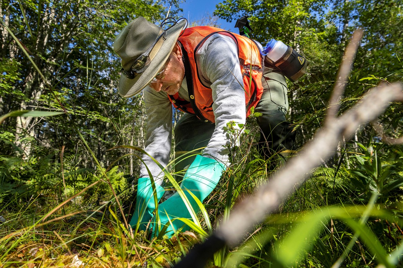
Botanical surveys indicate that the areas around Great Meadow and Sieur de Monts have the highest concentration of invasive plant species in the entire park. The park’s Invasive Plant Management Team began to actively monitor and treat invasives in the Great Meadow watershed in 1993. But in spite of continued removal, many remain. Glossy buckthorn, in particular, is especially persistent. Vegetation crews have to work over 100 hours a year just to keep it at current levels in the Great Meadow.

Image credit: Friends of Acadia / Ashley L. Conti
In most cases, healthy wetlands within Acadia are naturally acidic and nutrient-poor. These conditions promote the development of sphagnum, also known as peat moss, which is a good indicator of wetland health. But Great Meadow has a low percentage of sphagnum, which means there’s a high concentration of inorganic soil. Inorganic soil is mainly mineral matter. Water moves through it more quickly than through organic soil, further reducing the wetland’s capacity to retain water.
The U.S. Geological Survey’s 2016 analyses of Great Meadow indicated that the undersized outlet culvert at the Park Loop Road was the primary cause of the wetland’s poor hydrology. Even when functioning properly, the culvert caused flooding at Sieur de Monts. Managing the culvert was time-intensive and expensive, and its existence led to more non-native plant species and less sphagnum. Plus, maintaining infrastructure that supported the very conditions we were trying to prevent felt a lot like chasing your tail. We needed a big change.

Image credit: NPS
Back to Nature, by Design
With federal funding from the Bipartisan Infrastructure Law, the park and its partners hired an engineering firm to help them understand the downstream impacts from wetland restoration and a new culvert design, particularly on Bar Harbor. The engineers’ model incorporated existing point data from the park’s rain gauge, continuous historic stream flow data, wetland water-level measurements, and topographic LiDAR and survey data. It used U.S. Army Corps of Engineers Hydraulic Engineering Center River Analysis software to extrapolate these discrete results to the entire watershed.
This enabled park staff to compare water levels in the Great Meadow to those downstream of the new culvert for different culvert configurations and restoration methods. Our goal was to select a road crossing that reduced peak flooding in Sieur de Monts, prevented damage to historic structures, and avoided impacts to infrastructure outside the park. The engineers used an iterative design process for creating the new culvert, where they repeatedly tested, analyzed, and refined successive prototypes until the design met the desired specifications.
The stream-simulation bottom would mimic a natural channel so that fish and other aquatic animals could cross through easily.

Image credit: VHB / Dave Cloutier
They concluded that the best solution would be a 12-foot box culvert with a 10-foot stream-simulation bottom. The stream-simulation bottom would mimic a natural channel so that fish and other aquatic animals could cross through easily. The flow through the channel would match the existing peak flow downstream. The design specs included repairing the stream channel immediately upstream and downstream from the crossing. This would create a floodplain to further dissipate energy from large storm events and help maintain a stable channel. The restoration would employ engineering with nature principles, using root wads and live staking to stabilize the new stream banks.
Upstream of the restored floodplain, the design called for a nature-like earthen berm.
Upstream of the restored floodplain, the design called for a nature-like earthen berm at the transition from wetland back to stream. Dave Cloutier, a senior water resource engineer on the project, said the berm was designed “to improve hydrology of the Great Meadow by reducing the severity of water level fluctuations.” The structure would enable the wetland to retain water in smaller rain events (the old culvert allowed the wetland to drain) and permit the controlled release of water from the wetland during heavier rain, preventing downstream flooding.

Image credit: VHB
The more sphagnum, the more water the wetland retains; the more water retained, the more sphagnum.
“With a more natural flow pattern in Great Meadow,” said Kate Miller, a quantitative ecologist who works for the National Park Service, “we expect to see increased peat buildup, greater plant diversity, and overall improved function.” Greater water retention will create a positive feedback loop, further stabilizing the hydrology: the more sphagnum, the more water the wetland retains; the more water retained, the more sphagnum.
A Shared Understanding
To augment the improvements in hydrology from the new culvert, we looked at the web of abandoned roadbeds and ditches that crisscrossed the Great Meadow. These past manipulations were for accessing and draining the wetland. Working with engineers, park staff devised a series of purges for the raised earthen roadways and plugs for the associated drainage ditches.Plans in hand, we consulted the Army Corps of Engineers, discussing permanent and temporary impacts and construction phasing and requirements. We also consulted the Maine State Historic Preservation Office, as some of the old roads, such as the Jessup and Hemlock Paths, are part of the Mount Desert Island Hiking Trail System, which is on the Natural Register of Historic Places. We developed treatments that preserved the integrity of the trails, while adding improvements to the wetland.
The park and its partners have worked to reframe how staff look at the landscape and to incorporate generational Indigenous knowledge.
Acadia National Park, Friends of Acadia, and Schoodic Institute have been working to develop new and meaningful relationships with the Wabanaki people. Acadia National Park’s program lead for Resource Management, Rebecca Cole-Will, has been collaborating with the Wabanaki to identify culturally significant plant species in the park. These conversations stemmed from the 2015 regulation change that permitted Indigenous gathering of plants by federally recognized tribes. The park and its partners have worked to reframe how staff, including project team members, look at the landscape and to incorporate generational Indigenous knowledge into the wetland restoration project.

Image credit: Friends of Acadia / Sam Mallon
The project team examined its assumptions about the Great Meadow, deciding it was time to slow things down and hold back on some of our planned actions. There were many more questions for us to consider: Did every change to the wetland occur after European colonization? Were we seeing every aspect? Who should identify pre-colonial or overlooked landscape features? How could we protect Indigenous cultural and intellectual property and the rights and interests of the Wabanaki? How could we protect their knowledge and cultural practices from misuse? Were we changing conditions that would favor culturally significant species? Were there culturally significant species that should be in the wetland but were long gone?
Co-stewardship with the Wabanaki means developing a shared understanding of what Great Meadow restoration is going to look like.
Co-stewardship with the Wabanaki means developing a shared understanding of what Great Meadow restoration is going to look like. We’re conducting additional surveys of the project area for rare plants and those with ethnobotanical importance. We’re giving Tribal members the time they need to reconnect with the landscape. And we hope to have future discussions with Wabanaki knowledge holders about culturally important plants that may face negative impacts from climate change.
Serving the Public
Restoring the Great Meadow doesn’t mean recreating the wetland that existed before Dorr bought the land. We’re not returning it to some historic state. It’s about creating conditions for the wetland to naturally rebuild its own functions and resiliency and preventing catastrophic downstream impacts. In order to do that, we have worked to understand its existing conditions, its stressors, and how change will affect it. This work, strengthened by partnerships and realized through structural changes made with the help of the infrastructure funding, benefits local Mount Desert Island communities and park visitors.

Image credit: Friends of Acadia / Ashley L. Conti
In addition to designing the new culvert, we’ve used Bipartisan Infrastructure Law funds to develop vegetation restoration experiments that test the effectiveness of seeding native plants for halting non-native plant invasions, which is crucial for wetland water retention. The tests are adaptable, so we can incorporate the lessons we learn from one set of tests when we design the next set. “These experiments should help us determine if competition can slow down the growth of invasive shrubs, allowing [the Invasive Plant Management Team] breathing room,” said Jesse Wheeler, the park’s vegetation program manager.
Investing in more appropriate infrastructure for the wetland through recent federal funding will save on long-term operation and maintenance costs.
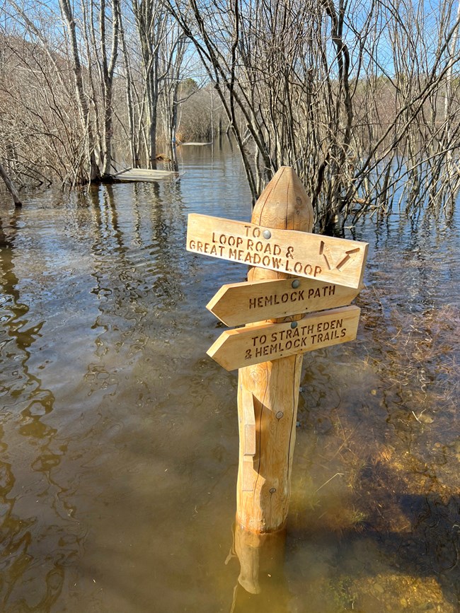
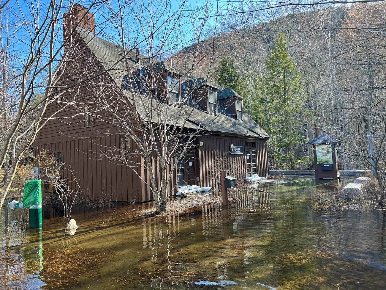
Annual precipitation in Acadia National Park has increased by about six inches since many of the park’s roads and trails were built. Scientists predict the area’s future climate will be hotter, with more frequent and intense precipitation. We have already seen more frequent flooding in the cultural landscapes at Sieur de Monts, including the Nature Center and Wild Gardens, and in the associated trail system in Great Meadow. This has led to limited visitor services, longer visitor use closures, and increased costs. With the help of the infrastructure funds, we’re proposing significant changes to existing trails. One such change is to add purges (large perpendicular ditches) across the trails to support wetland connectivity. Another change is to construct a boardwalk-style trail, compliant with the Americans with Disabilities Act, over the purges and above the flooded wetland. This will provide trail access to more people more of the time.

Image credit: Friends of Acadia / Julia Walker Thomas
The Great Meadow wetland restoration project will also help reduce overall park costs. Year after year, the park cleaned the undersized, clogged culvert in Great Meadow, but we couldn't do it before every storm. As storms became more frequent and intense, damage to historic structures and recreational assets increased. Investing in more appropriate infrastructure for the wetland through recent federal funding will save on long-term operation and maintenance costs for buildings, roads, and trails.
This hasn’t been an easy or quick path to follow. It has taken preparation, patience, and teamwork. We’ve had to be adaptable as the project evolves. But though our goals, timelines, and products may change, we’re developing deeper long-term relationships, gaining more meaningful results, and serving the public in more ways than we could ever have imagined.
About the authors


