|
You are viewing ARCHIVED content published online before January 20, 2025.
Please note that this content is NOT UPDATED, and links may not work. For current information,
visit https://www.nps.gov/aboutus/news/index.htm.
Naomi Lofton
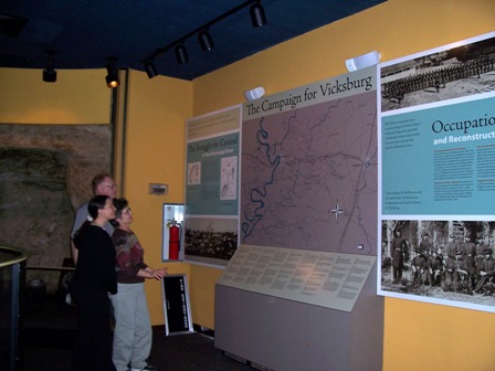
Contact: Tim Kavanaugh, (601) 636-0583 Contact: Visitor Desk, 601-636-0583 Contact: Terrence Winschel, (601) 619-2908 Vicksburg National Military Park has installed a new fiber optic map and exhibit panels to highlight the complex military operations that focused on the city of Vicksburg which, during the Civil War, was known as the "Gibraltar of America." President Abraham Lincoln referred to Vicksburg as the "key," and said "The war can never be brought to a close until the key is in our pocket." The campaign for Vicksburg was one of the largest and most decisive of the Civil War and resulted in surrender of the city to Maj. Gen. Ulysses S. Grant on July 4, 1863. Union victory at Vicksburg gave the North control of the Mississippi River, split the Confederacy in two, severed major Southern supply and communications lines, achieved a major objective of the Anaconda Plan, and effectively sealed the doom of Richmond--the Confederate capital. In addition to the map, three new exhibit panels were also installed. The illustrated panels address the unique role of slavery as it related to the outbreak of war, the early military operations for Vicksburg, as well as the history of Vicksburg under Union occupation during the war through the era of Reconstruction. |
Last updated: April 14, 2015