An official website of the United States government
Here's how you know
Official websites use .gov A
.gov website belongs to an official government
organization in the United States.
Secure .gov websites use HTTPS A
lock (
) or https:// means you've safely connected to
the .gov website. Share sensitive information only on official,
secure websites.
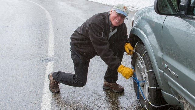
Be prepared for snowy mountain roads! Chains may be required at any time.
Which Entrance Do I Go To?
Ash Mountain Entrance to Sequoia National Park
Highway 198 enters Sequoia National Park at the town of Three Rivers. Beyond the entrance station, the road is narrow and winding.
Vehicles longer than 24 feet (7.3 m) are not advised between the Foothills Visitor Center and Potwisha Campground. Vehicles longer than 22 feet (6.7 m) are not advised between Potwisha Campground and the Giant Forest Museum.
Big Stump Entrance to Kings Canyon National Park
Highway 180 enters Kings Canyon National Park from the west via Fresno.
Highway 180 is the preferred route for longer vehicles. It is straighter, less steep, and wider.
Lookout Point Entrance to the Mineral King Area
If you're heading to the remote Mineral King area of Sequoia National Park, look for the junction of Mineral King Road with Highway 198 in the town of Three Rivers, two miles before the Ash Mountain Entrance.
This road is extremely narrow and winding and is unpaved in some areas. RVs and trailers are not advised and are not permitted in the campgrounds.
Only trails connect Mineral King with the rest of Sequoia National Park. No roads cross the mountains west-to-east through Sequoia and Kings Canyon National Parks.
No Fuel
There are no gas stations or chargers within park boundaries, though there are limited, seasonal stations on nearby national forest lands. Electric vehicle charging stations may be available near the parks.
If you drive to these parks, be prepared for driving mountain roads that are steep, narrow, and winding. Length limits and advisories are in place for RVs, trailers, and any other vehicles over 22 feet (6.8 m) in length. If you drive an RV or a vehicle with a trailer, check advisories before you visit.
No gasoline is sold within the parks, though there are gas stations at nearby national forests. Depending on your vehicle, electric vehicle charging stations may be available at park lodges
Access to park roads varies by season. Tire chains may be required on park roads any time it snows, usually late fall, winter, and through spring. Chains are available for purchase or rent at locations near park entrance stations. Learn more about chains and other winter driving information before you plan your visit.
Due to heavy visitation, be prepared for delays at park entrances. In summer, on Fridays, Saturdays, and on holidays from Memorial Day to Labor Day, long lines of cars have extended from the entrance stations. Learn how to plan for a wait at the entrance station.
Greyhound Lines stops in the city of Visalia at the Visalia Transit Center, and in the City of Fresno at the Fresno Greyhound Station. Once in Visalia, it's possible to connect with park shuttle routes in summer to take you to Sequoia National Park. In other seasons, renting a vehicle is an option.
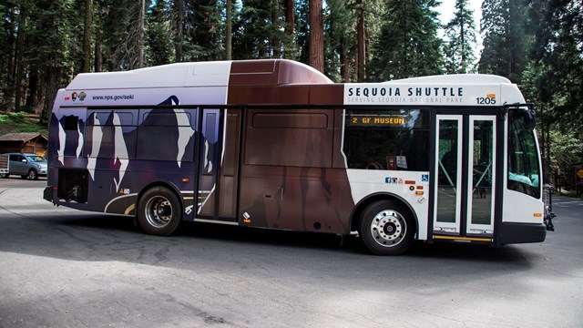
The City of Visalia's V-Line bus route provide service between the Visalia Transit Center and Fresno-Yosemite International Airport., with additional stops at Fresno State University and the Visalia Municipal Airport. In summer, this route connects with the Sequoia Shuttle.
Tulare County Area Transit offers service from the Visalia Transit Center to the Memorial Building in the town of Three Rivers. Many companies begin guided sightseeing tours in Three Rivers. There are many private companies offering guided tours of the parks by charter bus.
Fresno Yosemite International (FAT) is 1 ¼ hours from the Kings Canyon National Park entrance on Highway 180 and 1¾ hours from the Sequoia National Park entrance on Highway 198. From the airport, you can rent a car to reach the parks.
Visalia Municipal Airport (VIS) is 1 hour from the Sequoia National Park entrance on Highway 198 and 1½ hours from Kings Canyon National Park entrance. From the airport, you can rent a car or, in summer, take a bus to the Visalia Transit Center, where Sequoia Shuttle provides summer shuttle service to Sequoia National Park.
Arriving by Train
The nearest Amtrak stations to the parks are in Hanford and Fresno.
From Hanford, Amtrak has bus connections to Visalia Transit Center, where it is possible to make a connection with the Sequoia Shuttle (summer only). Hanford is about 20 miles west of Visalia, one hour and 45 minutes from the Sequoia National Park Entrance on Highway 198.
The Amtrak station in Fresno is about one hour and 45 minutes from the Kings Canyon National Park entrance on Highway 180.
Car rentals may be available near the Hanford and Fresno Amtrak station. Check with Amtrak for more details.