
NPS Photos Addresses:Please note, if you are using Google Maps to navigate to the park, please use "Munising Falls Visitor Center", or "1505 Sand Point Road, Munising MI" as your routing point! Using "Pictured Rocks National Lakeshore" will NOT bring you to a visitor center! Munising Falls Visitor Center:1505 Sand Point Road, Munising, MI 49862. Grand Sable Visitor Center:E21090 County Road H-58 (Two miles west of Grand Marais, Michigan)
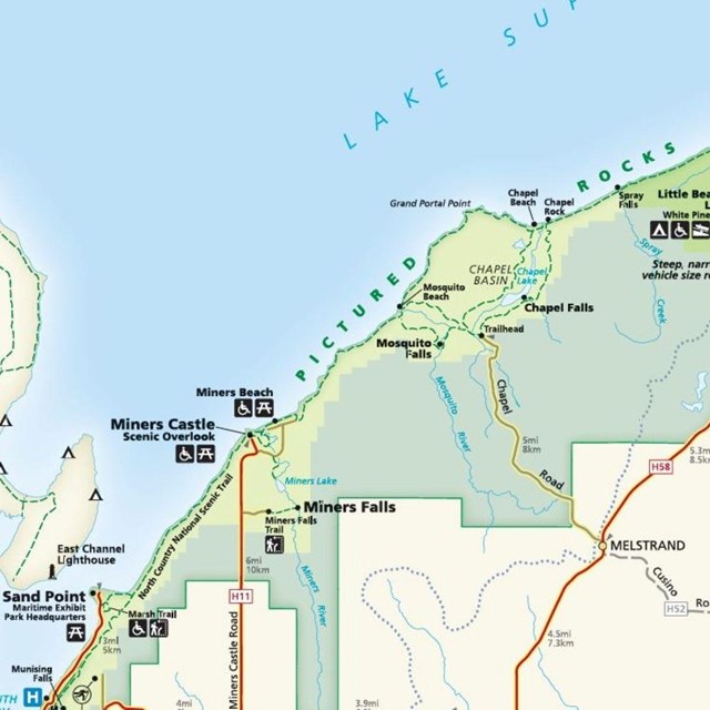
Getting to Pictured RocksPictured Rocks National Lakeshore is located on the south shore of Lake Superior in Michigan's Upper Peninsula, between the communities of Munising (west) and Grand Marais (east). The main park visitor center is located in Munising at Munising Falls. CarMichigan state highways M-28 and M-94 lead to Munising. State highway M-77 leads to Grand Marais. Alger County Road H-58 and other spur roads (some unpaved) provide access throughout the lakeshore. Many roads are closed by snow during the winter. See winter road closure page for more information. PlaneGrass airfields are located near Grand Marais and Munising. Regularly scheduled commercial airline service arrives at Marquette, Escanaba, and Sault Ste. Marie, Michigan. BusRegional bus lines stop in Marquette and Escanaba. Please visit Shuttle Service for information on local transportation. Getting Around Pictured RocksCarThe main road that travels through the national lakeshore is Alger County Road H-58. Other access roads (some unpaved) that lead to lakeshore sites such as campgrounds, day use areas, scenic views, and trailheads are clearly marked on the park map. Please stay on H-58 and these official roads. BicyclesBicyclists should be aware that long sections of H-58 have very little shoulder or no shoulder at all. Also be aware that H-58 is used by large logging trucks and many types of ORVs. Use care while cycling on this curvy road. ORV and ATVORVs and ATVs are prohibited in park campgrounds, as well as driving or parking on road shoulders, and NO off road travel. Outside of campgrounds, ORVs and ATVs must park in designated vehicle parking lots. Recreation VehiclesThe park's campgrounds and several other unpaved roads are not well suited for the largest RVs, motorhomes, or trailers. For information about the campground site vehicle limits (including photos), please visit the Drive-in Camping page. Unpaved Park Roads with Size Restrictions:
Other areas not well suited for large vehicles:
Sites that are accessible by large RVs and motorhomes:Areas within the park that accommodate large recreation vehicles are limited. Most parking lots are small. Locations with the larger parking lots are:
|

Last updated: August 26, 2024