|
You are viewing ARCHIVED content published online before January 20, 2025.
Please note that this content is NOT UPDATED, and links may not work. For current information,
visit https://www.nps.gov/aboutus/news/index.htm.
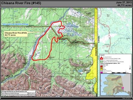
Tok, Alaska –– Fire managers are continuing to monitor the Chisana River Fire with surveillance flights to size up the acreage and observe fire behavior.The fire, burning in Wrangell-St. Elias National Park and the Tetlin National Wildlife Refuge, has grown to 44,531 acres.The growth in acreage was on the south side of the fire, along the eastern edge of the Chisana River, with minimal growth to the north and east. Currently, no resources are
threatened by the fire.However, fire
managers have developed contingency plans and are prepared to take action if
resources are threatened. The fire is approximately 13 miles west of the
Canadian border, 18 miles west of Beaver Creek, Yukon, Canada and The Alaska Division of Forestry has assembled a combined Alaska/Canada organization of fire managers, based in Beaver Creek, for better proximity to the fire. The fire has sent a smoky haze over portions of the Copper River Valley and along the Alaska Highway. If smoke impacts the Alaska Highway, motorists are asked to use caution, slow down, and drive with their headlights on.Updated information on travel conditions can be found at http://511.alaska.gov and www.511yukon.ca Wildland fire smoke information is available at http://www.dec.state.ak.us/air/smokemain.htm. A Fuels and Fire Behavior Advisory remains in effect for most of Alaska.Read more at: http://fire.ak.blm.gov/content/weather/outlooks/FFBehavior.pdf. Photos and maps of the Chisana River Fire are available at http://inciweb.org/incident/3440/. Information is also available at https://www.nps.gov/wrst/parkmgmt/currentfireinfo.htm |
Last updated: April 14, 2015