Last updated: December 7, 2023
Thing to Do
Contemplate Your Place in the Landscape At The Big Map
NPS
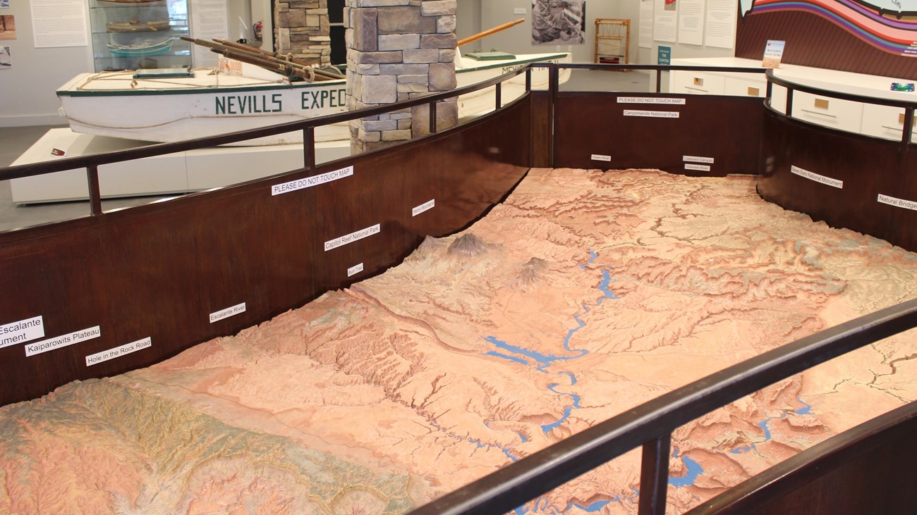
During the construction of Glen Canyon Dam, The U.S. Bureau of Reclamation commissioned a scale model relief map of what would be Lake Powell and the surrounding area. Model map builder Robert Miller used information from topographic maps and overflights of the area to construct the model in his basement. It took over a year to complete. He cut the map into seven pieces to be transported to the opening of the Glen Canyon Visitor Center, later renamed after Arizona senator and water use proponent Carl Hayden.
This terrain relief model of the Glen Canyon National Recreation Area and vicinity can only be described as precisely accurate. The topography shown was based on both topographic maps and aerial photographs. Everything on the map actually exists just as it appears to, considering the vertical scale of the model. When it was installed at the visitor center at Glen Canyon Dam, is was oriented to real life. You could use it for wayfinding.
In 2017, during the installation of new exhibits at Carl Hayden Visitor Center, the relief map was cut into the original seven pieces and removed from the building. Two years later, park partners Glen Canyon Conservancy retrieved the pieces and reassembled the map at their Flagship office and retail store for the public to once again enjoy and plan trips. In mid-2023, renovations at the Powell Museum & Archives were complete, so the map has a forever home amongst relevant exhibits. Over 55 years after its construction, aside from a few new roads, the map still accurately depicts the landscape of and around Glen Canyon National Recreation Area.
Details
Duration
1-120 Minutes
Take a second glance, take an afternoon. Our friends welcome visitors to take their time (while the building is open) and see what they can find on the map.
Activity
Museum Exhibits
Find your place in the landscape. Contemplate your place in the world. It's easy to get lost in this desert canyon landscape, but much easier to find your way out of here than from the real canyons!
This terrain relief model of the Glen Canyon National Recreation Area and vicinity can only be described as precisely accurate. The topography shown was based on both topographic maps and aerial photographs. Everything on the map actually exists just as it appears to, considering the vertical scale of the model. When it was installed at the visitor center at Glen Canyon Dam, is was oriented to real life. You could use it for wayfinding. You could use it for mind wandering.
Bonus secret: Bob Miller created the map with such accuracy, he included 12 natural bridges and arches in the topography. How many can you find?
Age(s)
All ages can view the map, but please do not touch or try to get on it.
Pets Allowed
No
Activity Fee
Yes
Admission to the museum is as follows:
GENERAL: $12
MILITARY / SENIOR 62+: $10
STUDENTS 10-17: $5
CHILDREN 0-9: FREE
LOCAL RESIDENTS: FREE
TOUR GROUPS (WITH ADVANCE NOTICE): $5 PER PERSON
Location
Glen Canyon outside of Glen Canyon
In the City of Page, the Powell Museum & Archives are at 6 Lake Powell Blvd. Our friends at Glen Canyon Conservancy host the big relief map among the exhibits in the museum. Admission to the museum is required.
Reservations
No
Season
Year Round
Time of Day
Day
The Powell Museum & Archives are open every day 9am-5pm. There may be reduced hours in winter. Please visit Glen Canyon Conservancy's website for up to date information.
Accessibility Information
The relief map is about three feet high, 12 feet long. A railing surrounds it, leaving room for wheelchair approach.
The exhibits in the building are on a flat floor, and a ramp is available to make way to the gift shop.
Service animals are permitted in the building.