Last updated: June 29, 2023
Thing to Do
Stargaze in Parashant
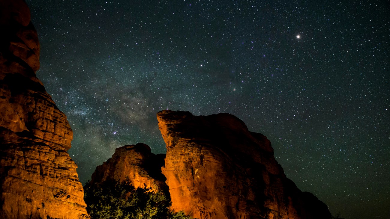
Discover Parshant's Dark Night Skies
Designated an International Dark Sky Province, Parashant offers many opportunities to experience pristine night skies.The night sky is everyone's heritage; however, natural darkness is becoming rare.
Stargazing Safety
-
Visit your chosen location during the day to scout out possible safety hazards, like uneven ground and drop-offs.
-
Completely pull off the road and park your vehicle in a designated parking space.
-
Wear reflective and brightly colored clothes so motorists and other people can see you.
-
Use a red flashlight to help preserve your night vision.
-
Bring a few extra light sources.
Want to do more than just stargaze?
Learn about photographing the night sky and how to safely take a night hike. Explore the night sky with NASA's Skywatching Tips. Discover what's happening in the night sky where you live with NASA's Night Sky Planner.
Details
Activity
Stargazing
Grand Canyon-Parashant National Monument remains one of the most remote areas in the contiguous United States. The monument and surrounding geographic region are recognized for remarkable combinations of high elevation plateaus, excellent air quality, sparse population, and prevalent cloud-free weather all of which provide for some of the best opportunities to visually observe and enjoy dark night skies.
Natural darkness and dark night skies are important resources and recognized monument objects of Parashant. Dark night skies are a rapidly disappearing resource around the world as inefficient and ineffective light sources increase. By working with the National Park Service Colorado Plateau Dark Sky Cooperative, the monument was able to produce an inventory of the existing night sky conditions and obtain a Gold-tier status from the International Dark-Sky Association. Data from this inventory and future studies will be used for future monitoring on the monument.
Natural darkness and dark night skies are important resources and recognized monument objects of Parashant. Dark night skies are a rapidly disappearing resource around the world as inefficient and ineffective light sources increase. By working with the National Park Service Colorado Plateau Dark Sky Cooperative, the monument was able to produce an inventory of the existing night sky conditions and obtain a Gold-tier status from the International Dark-Sky Association. Data from this inventory and future studies will be used for future monitoring on the monument.
Pets Allowed
Yes
Activity Fee
No
No entrance pass is required.
Location
Grand Canyon-Parashant National Monument
Grand Canyon-Parashant National Monument epitomizes much of the “Wild West”—a vast, wild landscape of desert cactus and sheer canyon walls, soaring raptors and tall ponderosa pines, isolated cattle corrals and line shacks, lone cowboys, and rugged rock formations set against endless dark night skies.
The monument is in Mohave County, Arizona, immediately north of Grand Canyon National Park and the Colorado River and east of the state of Nevada. Altogether, it encompasses 1,048,321 acres.
With the Grand Canyon plunging thousands of feet deep along the south perimeter and only rough, unpaved roads providing entry from the north, west, and northeast, Grand Canyon-Parashant National Monument is one of the most remote areas within the 48 contiguous states. No towns or communities lie within its boundaries. The nearest towns (Littlefield, Beaver Dam, Scenic, Fredonia, Colorado City, and Centennial, Arizona; Mesquite and Bunkerville, Nevada; and St. George, Utah) are all more than an hour’s drive from the monument boundaries. Travel anywhere in the monument, except its outermost edges, requires slow driving over rough terrain, often in a high-clearance, four-wheel-drive or off-highway vehicle (OHV)
4x4 Vehicles and Off-Pavement Travel Safety
Road Descriptions and Difficulty Ratings
Reservations
No
Time of Day
Night
Accessibility Information
Accessible Vault Restrooms
There are several accessible vault toilets available at the following locations within the monument. The vault toilets themselves are accessible, but do not have hardpacked or paved trails from the parking area to them at this time.
-
Mount Trumbull Trailhead on County Road 5
-
Poverty Mountain on County Road 103 at the junction with BLM1046
-
Pakoon Springs on BLM111
-
Grand Gulch Mine at the landing strip on BLM1002
-
Nampaweap Trailhead on BLM1028
-
Tassi Ranch on NPS1213