Last updated: August 14, 2017
Thing to Do
Hike the Harding Icefield Trail
Ranger Recommendation
Keep your eyes open! Stops along the way at Marmot Meadows (1.4 miles) and Top of the Cliff (2.4 miles) provide scenic vistas to take a break during your journey or turn around for a shorter hike. Watch for wildlife throughout your hike, as bears, mountain goats, hoary marmots, and others, have all been seen from the trail.
Be prepared! Check on trail conditions before starting out - the upper portion of the trail is often covered with snow through early July, and there may be avalanche danger. Be prepared for storms, high winds, intense sunlight, and sudden temperature changes. Bring warm clothes, rain gear, sturdy footwear, sunglasses, and sunscreen. Carry plenty of water (at least 2 liters per person).
Stay on the trail. Alpine vegetation is extremely fragile. Careless hikers who cut switchbacks, along with frequent summer rains, cause tremendous erosion. Volunteers help restore and maintain this trail every year. Please respect their hard work by sticking to the trail.
Details
Duration
6-8 Hours
As an out and back trail, hike as far as you would like. Good shorter options with scenic views are Marmot Meadows (1.4 mi one way) or Top of the Cliffs (2.4 mi one way).
Activity
Front-Country Hiking
Pets Allowed
No
Activity Fee
No
Entrance fees may apply, see Fees & Passes information.
Location
Exit Glacier Area
Directions to Exit Glacier
Turn on to Herman Leirer Road, commonly called "Exit Glacier Road," at mile 3 of the Seward Highway (AK-9). Proceed 8.4 miles. The road will end at the parking lot for the nature center. Proceed down the paved trail to the Harding Icefield Trailhead.
Turn on to Herman Leirer Road, commonly called "Exit Glacier Road," at mile 3 of the Seward Highway (AK-9). Proceed 8.4 miles. The road will end at the parking lot for the nature center. Proceed down the paved trail to the Harding Icefield Trailhead.
Reservations
No
Season
Summer, Fall
Snow can often still be found on the trail until late-June to early-July. Avalanche hazards can exist in late spring and early summer as well. New snow could be found on the trail during the fall. Check current conditions before heading out on the trail.
Time of Day
Any Time
Accessibility Information
The trail ascends steeply over the 4.1 miles, gaining around 3500' of elevation. The surface can be muddy, slippery, rocky and include snow and ice depending on the time of year. Though pets are prohibited on this trail, service animals are able to accompany visitors.

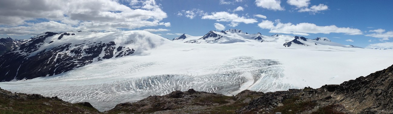
NPS Photo / F. North
The 8.2-mile round trip Harding Icefield Trail is a spectacular day hike. Starting on the valley floor, the trail winds through cottonwood and alder forests, passes though heather filled meadows and ultimately climbs well above tree line to a breath-taking view of the Icefield. The top of the trail is a window to past ice ages - a horizon of ice and snow that stretches as far as the eye can see, broken only by an occasional nunatak, or lonely peak.
This is a strenuous hike. Hikers gain approximately 1,000 feet of elevation with every mile. Allow at least 6-8 hours for the hike. Although the view from the top is well worth the effort, you need not hike all the way to the top to experience the wonders of this trail. A short hike up the trail affords impressive views of the valley floor and Exit Glacier's terminus.