
NPS Photo
Since 2000, the American Society of Landscape Architects (ASLA) and the National Park Service Rivers, Trails, and Conservation Assistance program have worked together to support dozens of community-led natural resource conservation and recreation projects. ASLA volunteers from local chapters across the country provide pro-bono assistance to communities the National Park Service supports. ASLA designated 2013 as the Year of Public Service to spotlight the community service performed by landscape architects across the nation, and to engage the public with the landscape architecture profession.
In 2013, both organizations increased their partnership efforts to help plan and design trail systems, parks, and other recreation projects. The partnership between the National Park Service and ASLA provides communities with access to expert planners and designers that can turn their ideas into actions, supporting healthy communities and extending the missions of the National Park Service and ASLA to all Americans. Here are some successes from the Year of Public Service.
NPS Photo / Lisa Holzapfel
The Kachemak Bay Water Trail (KBWT) in Homer, Alaska, is a proposed 125-mile water trail that inspires exploration, understanding, and stewardship of the natural treasure that is Kachemak Bay. The trail will provide a safe, logical route for boaters to explore the bay from Homer, northeast to the head of the bay, and back to Seldovia, weaving into inlets and around islands. The KBWT is in the second year of planning. When completed, the trail will include shoreline amenities such as launch sites, overnight lodging opportunities, camping areas, hiking trails, educational and interpretive signs, and more.
ASLA Alaska Chapter members have been actively engaged in this project from its inception. Jonny Hayes and Mark Kimerer created a number of logos for consideration by the Kachemak Bay Water Trail steering committee and facilitated the "design by committee" process to select the final logo, which has been used extensively to promote the water trail vision. Jonny and Mark have continued to lend their expertise to help the steering committee identify water trail branding options, develop a site inventory review form, evaluate potential launch sites, and prepare an RFP for the design/build of a water trail website. In April, Jonny will be leading a planning and programming discussion with key stakeholders for the Homer Kachemak Bay Water Trail launch site.

NPS Photo / Lisa Holzapfel
The Palmer Bike Park, in Palmer, Alaska, is envisioned as a place where cyclists of any ability can learn and hone biking skills so they can ride and enjoy all types of terrain. Cyclists of all ages will be able to improve their biking abilities, learn how to bike safely, and have fun. At the park they will learn the skills and confidence they need to ride their bikes anywhere, from sidewalks to roadway bike lanes to backcountry mountain bike trails.
To help move this project forward, ASLA members Eric Morey (ASLA Alaska Chapter) and Luanne Urfer (ASLA Washington Chapter) collaborated with the National Park Service Rivers, Trails, and Conservation Assistance Program and volunteered a generous amount of their time and expertise as participants in every part of the planning and early concept generation process including crafting the initial vision and building community support.
Viewed as stepping stones toward the larger Palmer Bike Park, smaller neighborhood parks and bike pump parks also are being developed to encourage kids and families to get outside and play and to create a constituency for the bike park. One such smaller park is the Wilson Neighborhood Park. Eric, Luanne, and Zach Babb (ASLA Alaska Chapter), put kids' dreams to paper during the 2012 Wilson Neighborhood Park design workshop. Thanks to these ASLA members' colorful conceptual drawings, the city of Palmer approved funding for design and engineering and the community now looks forward to construction beginning this summer.
NPS Photo
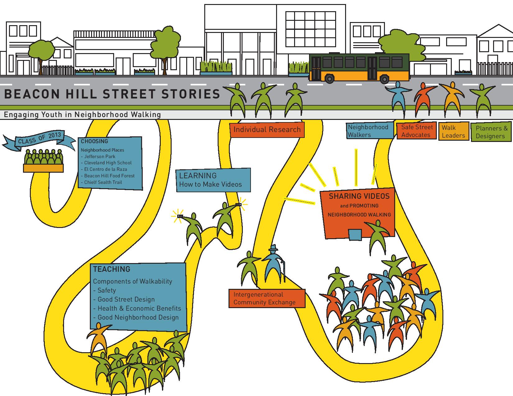
"Beacon Hill Street Stories" is a pilot project in Seattle, WA to creatively engage youth in exploring how the built environment shapes their experiences walking in their neighborhood. The pilot 5-week curriculum merges storytelling, technology and neighborhood culture, and is envisioned as a model for reaching and advancing the voice of youth in supporting vibrant, walkable communities throughout Washington State.
The project brings together the energy and expertise of the ASLA Washington Chapter (WASLA); Feet First, a dynamic non-profit promoting walkable communities; Seattle Parks and Recreation; and the National Park Service, through its Rivers, Trails, and Conservation Assistance program and Klondike Gold Rush – Seattle Unit National Historical Park,. WASLA volunteers joined the planning team at the beginning of March, 2013 to help shape the curriculum and spent a few afternoons per week in the field and classroom with middle and high school youth looking at the street environment and urban design and how these contribute to a walkable neighborhood. The students learned digital storytelling and video editing, and premiered their "street stories" in summer 2013 at the Beacon Hill Festival, the Klondike Gold Rush National Historical Park and multiple venues online.
Beacon Hill Street Stories" is the twelfth project WASLA and the National Park Service have partnered on through a 15-year agreement, and is one of the chapter's 2013 "Year of Public Service" Projects.

NPS Photo / Courtesy of John Stevenson, ASLA

NPS Photo

NPS Photo / Courtesy of ASLA
Tularosa Creek Discovery Trail
The Mescalero Apache Tribe, located in southeast New Mexico, is working to address a variety of health issues including hypertension, diabetes, obesity and physical inactivity among the population. Securing a Community Transformation Grant from the Centers for Disease Control and Prevention and the New Mexico Department of Health, the Mescalero community formed a Healthy Kids Healthy Mescalero coalition to develop a new greenway trail, improve other paths and sidewalks, and address healthy eating strategies. The National Park Service Rivers, Trails, and Conservation Assistance program worked with the coalition to capture their vision and ideas of what features the Discovery Trail should contain. A planning workshop would have been ideal to develop the trail concept, but logistics and travel distances prevented the team from using this technique. Instead, the ASLA New Mexico Chapter (ASLA) provided expertise in developing "montages" that reflected the ideas proposed by the Mescalero community. The montages capture Discovery Trail elements that address physical, mental and social health. Play pockets are envisioned for climbing, swinging and balance. Other areas focus on gathering areas, traditional shade structures and a Mescalero War Chiefs memorial area help community members better connect with their proud culture. ASLA contributed over 60 hours of pro-bono time in developing the professional montages.
At a December 2013 Healthy Kids Healthy Mescalero coalition meeting, participants walked the trail alignment and envisioned the discovery areas based on the montage displays at various locations. Additional ideas and suggestions were offered to the project team to strengthen the play pockets and trail features. The project team has gained complete consensus from the coalition for developing a three-quarter mile greenway connecting to six miles of improved walking routes that feature active discovery play areas and gathering places for physical, mental and social health.

NPS Photo

NPS Photo / Courtesy of Aaron Defenbaugh, ASLA
A Vision for Eldon Community Trails
Eldon community leaders have a dream to turn the Rock Island Line rail corridor into a community walking and biking trail. In 2013, they joined forces with the National Park Service and the Prairie Gateway and St. Louis chapters of the American Society of Landscape Architects (ASLA) to conduct a visioning session to facilitate a discussion of project goals, objectives, and ideas for the trail corridor and broader community trail connections. The information gathered was used to develop a conceptual plan for the city including potential connections to community and regional resources, impacts on infrastructure, traffic, utilities and economic development which could be used to leverage future project funding. Partnerships with the city of Eldon, the Eldon Chamber of Commerce, and the PAVE AmeriCorps program have led to improvements in conditions along the rail corridor. The eastern portion of the proposed trail was cleared last year by local volunteers and members of the AmeriCorps National Civilian Community Corps; a local contractor was hired to clear brush along the western part of the railroad right-of-way.
The trail corridor cuts right through Eldon's central business district, providing opportunities for connecting to and enhancing the community's social and economic life and for connecting to its history. For more information, see the Prairie Gateway and St. Louis chapters of ASLA.

NPS Photo / Courtesy of ASLA
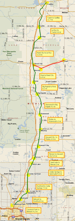
Cadillac-White Pine Trail Connector
The Fred Meijer White Pine Trail is Michigan's longest rail-trail, stretching a distance of 92 miles on the former Grand Rapids and Indiana rail bed. The trail connects the city of Grand Rapids to the city of Cadillac and more than a dozen communities in between. It forms the spine of Michigan's rail-trail network, which is the largest in the country. The rail-trail stopped short of downtown Cadillac. The National Park Service is working with the city of Cadillac, Michigan Chapter of ASLA (especially volunteer Craig Hondorp), Michigan Department of Natural Resources, Friends of the White Pine Trail, Convention and Visitor's Bureau, Rotary Club, and others to extend the trail into the heart of the city as part of the city's redevelopment.
The National Park Service is facilitating the planning process and ASLA member Craig Hondorp has developed alternative trail and trailhead concept plans based on the planning team's vision, goals and objectives. A preferred concept plan will be selected through a series of stakeholder meetings and a public open house in spring 2014. The City, National Park Service, Michigan DNR, and ASLA will then further refine the concept plan to generate cost estimates so grant application can be written and submitted for 2015 engineering and construction funding.

NPS Photo / Courtesy of ASLA
Virgil Parris Preserve-South Pond Access and Restoration
By 2008, the Western Foothills Land Trust had assembled 1,250 acres, including 49-acre South Pond, in Hebron and Buckfield, Maine to create the Virgil Parris Preserve. The National Park Service Rivers, Trails, and Conservation Assistance program was invited to assist in creating a management plan for the preserve. The most accessible and most visited area in the preserve is the east shore of South Pond. The project partners felt that the area would benefit from site improvements and the National Park Service suggested working through the American Society of Landscape Architects (ASLA) as part of the partnership between the National Park Service and ASLA to collaborate with a landscape architect. Barry Hosmer, a landscape architect with the Maine sub-chapter of the Boston Chapter of ASLA, volunteered to help.
After several site visits, a simple site plan emerged with an emphasis on restoring areas of erosion near the pond created by ad hoc motorized trails. In addition, the plan calls for a small parking area, an informational kiosk, a fire ring, and improvement of the hand-carry boat access. Conversations have begun with local schools in hopes of involving students in the collection, propagation, and planting of native plants to restore the eroded areas. The land trust and the NPS are currently working on identifying grants to fund the project and will be meeting with neighbors and local users to explain the plans for improved access and restoration.

NPS Photo / Courtesy of ASLA
The National Park Service Rivers, Trails, and Conservation Assistance program is providing technical assistance to Philadelphia Local Initiatives Support Corporation (LISC), a national organization that supports neighborhood community development corporations and the Mantua Beautification Committee to plan a community greenway in Mantua, a neighborhood in West Philadelphia. The project is a collaborative effort engaging residents and community stakeholders in the planning and renovation of the Mantua Avenue corridor, along the northern boundary of the neighborhood. The vision for the Mantua Greenway is to serve as a catalyst for economic development and act as the community's "front yard," welcoming residents and visitors with colorful native trees, public art displays, creative design features, and safe bike and pedestrian routes that illustrate Mantua's ecology, culture, history, and creative capacity—while improving access to Philadelphia's cultural and recreational opportunities.
During the fall of 2013, the National Park Service used their national partnership with the American Society of Landscape Architects (ASLA) to connect with a Philadelphia University landscape architecture studio to create several concept plans for the greenway. Throughout the fall, the Philadelphia University students worked closely with the Mantua Beautification Committee and National Park Service staff to research and analyze the physical corridor and the community's vision for the Mantua Greenway. In November, the students presented their final master plans to Mantua residents. After seeing the seven different concept plans, the residents voted on their favorite elements in each plan. This spring, the partnership will continue as the students work together with local ASLA professionals to synthesize the designs and the community's feedback and create one cohesive plan.

NPS Photo / Courtesy of Dwight Iwasa, ASLA
Hele On Kaka'ako: Cyclovia Hawaii
On Mother's Day in May 2013, the neighborhood of Kaka'ako in Honolulu, Hawaii had a "Hele On Kaka'ako" celebration and experienced Oahu's second cyclovia, which closed many streets to motorized transportation. The success of the event came from the volunteers who dedicated time, energy, and hard work to create a complete street demonstration and opened up streets for play for the day and allowed people to experience a bike and pedestrian friendly street with outside spaces for people and businesses to use.
Cycle On Hawai'i created the vision and support to implement the event. However, to make it happen, the event required an enormous amount of professional volunteer support. The National Park Service Rivers, Trails, and Conservation Assistance program worked with Cycle On Hawai'i, the Hawaii Chapter of the ASLA and numerous organizations and volunteers to make the event possible. Tireless landscape architects dedicated time, expertise, and contacts to turn a typical urban concrete street into a vibrant, bike and pedestrian-friendly street. Collectively, these volunteers designed and installed parklettes, green infrastructure, mini traffic circles, and an urban food forest for the day. The event aimed to educate and inspire people to support healthy, sustainable community designs.Last updated: February 15, 2019