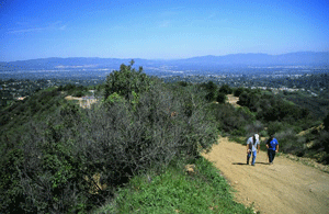
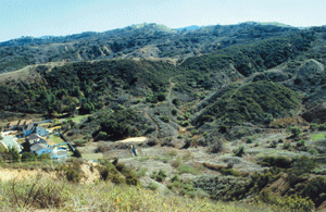
Offering some of the most accessible and user-friendly terrain in the Santa Monica Mountains, Marvin Braude Mulholland Gateway Park--named for the former Los Angeles City Councilman, who for more than 30 years led the effort to preserve the Santa Monica Mountains--encompasses 1,500 acres of wild land above the unpaved portion of Mulholland Drive and the west San Fernando Valley. Connecting with Topanga State Park and the 20,000 acre “Big Wild,” the park offers hikers, mountain bikers and equestrians trails that lead into an urban-adjacent wilderness, perhaps unparalleled anywhere in the world. The principal trailhead is at the southern terminus of Reseda Boulevard. The park has beautifully manicured lawns, gorgeous city and mountain views, ample parking, restrooms, and potable water. 
Site Info & Map Marvin Braude Mulholland Gateway Park map (PDF) Directions San Fernando Valley: Ventura Fwy (101) to Tampa Ave exit. East (left) on Ventura Blvd for 1 mile then south (right) on Reseda Blvd for 3 miles. Park at the end of the road. Los Angeles: Ventura Fwy (101) to Reseda Blvd. exit. South (left) on Reseda Blvd for 3.5 miles. Park at the end of the road. This site is managed and operated by the Mountains Recreation and Conservation Authority in partnership with the Santa Monica Mountains Conservancy. |
Last updated: September 25, 2018