Exploring the BackcountryFrom cactus-covered desert to pine-cloaked mountain heights, the Saguaro Wilderness Area in the Rincon Mountains protects the last roadless ‘sky island’ mountain range in Southern Arizona. Designated by Congress in 1976 – along with lands in the Tucson Mountains – this Wilderness Area provides another layer of protection to your Saguaro National Park. Together with the adjacent Rincon Mountain Wilderness on the Coronado National Forest, the protected wild acreage totals nearly 100,000 acres within sight of the sprawling city of Tucson. Solitude awaits you on these cool, forested slopes. PermitsReservations for backcountry camping are required, and permits are available on Recreation.gov.
If you are hiking the Arizona Trail, you can get a thru-hiking overnight permit. 
NPS Photo / Vanessa Gonzalez Know Before You Go

Saguaro Wilderness Area
Learn more about exploring Saguaro's backcountry. 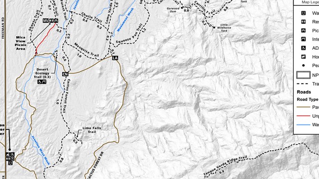
Maps
Our maps help you plan your trip and keep you safe navigating our wilderness. CampsitesCamping is allowed at 6 designated campgrounds within the Saguaro Wilderness Area. These camp sites are not accessible by vehicles and must be hiked to.

NPS Photo Juniper BasinThis campground is a tough day hike up the Tanque Verde Ridge over 6.9 miles and 3000 feet of elevation gain. Exceptional views can be seen throughout the hike, and habitats change quickly from desert scrub to oak savanna and pine / juniper woodlands. Water here is very seasonal, and it is often dry during the summer, spring and fall. When there is water, sources can be found west of site 1 (following a footpath to pools of water) and north of sites 2 and 3. Fires are allowed here only from collecting dead and downed wood. 
NPS Photo Douglas SpringThe closest access point to this campground is from the Douglas Spring trailhead. From there, it is a 6.5 mile hike with approximately 1800 feet of elevation gain. There are plenty of Mesquites and junipers in the area that provide some shade in the hotter months. This is the lowest campground and as such is ideal during winter storms that blanket the higher elevations with snow. 
NPS Photo / TWiewel Grass ShackGrass Shack is a great campground that offers shade from large oaks.. The biggest watershed in the Rincon mountains (Chimenea Creek) runs through and by the campground, providing water most of the year. Fires are not allowed here as this campground is in a fragile, riparian ecosystem surrounded by a thick grassland. 
NPS Photo / T. Wiewel Happy ValleyAround the back side of the Rincon Mountains is Happy Valley Road and access to the Miller Creek trailhead and Turkey Creek trailhead. Take exit 297 from Interstate-10 (Mescal Road). Be advised this is a rarely maintained dirt road that has multiple stream crossings. During wet winters and the monsoon season, this road may be impassable. 
NPS Photo Spud RockSpud Rock is the most isolated of our six campgrounds, sitting on the east side of the range at 7200 feet. Access is generally from the east, but Turkey Creek trailhead is very difficult to drive and requires a lifted truck or a jeep. At the very least, you will need a vehicle with four-wheel drive. Also, make sure to check the conditions of the road before heading out as it can become muddy and treacherous after some rain. 
NPS Photo / T. Wiewel ManningBuilt by former Tucson Mayor Levi Manning, this camp was his family's summer home. Now, this camp serves as a high elevation base for many of our fire and natural resource studies. At 8000 feet, Manning Camp exists in a completely different climate from the desert scrub that we experience down at the Visitor Center. There are six campsites here, and the area is mostly shaded by the ponderosa pines, making it a cool escape from the desert sun. This area is a savior from the sweltering heat in the valley below, rarely exceeding 85 degrees. A perennial water source near the cabin has only dried up twice in Saguaro's history, so water is almost always available. A sign leads down to it. Fires are a must at night with fire rings as lows typically are below 40 degrees until late May. |
Last updated: May 22, 2025