News Release

NPS Photo
|
Subscribe
|
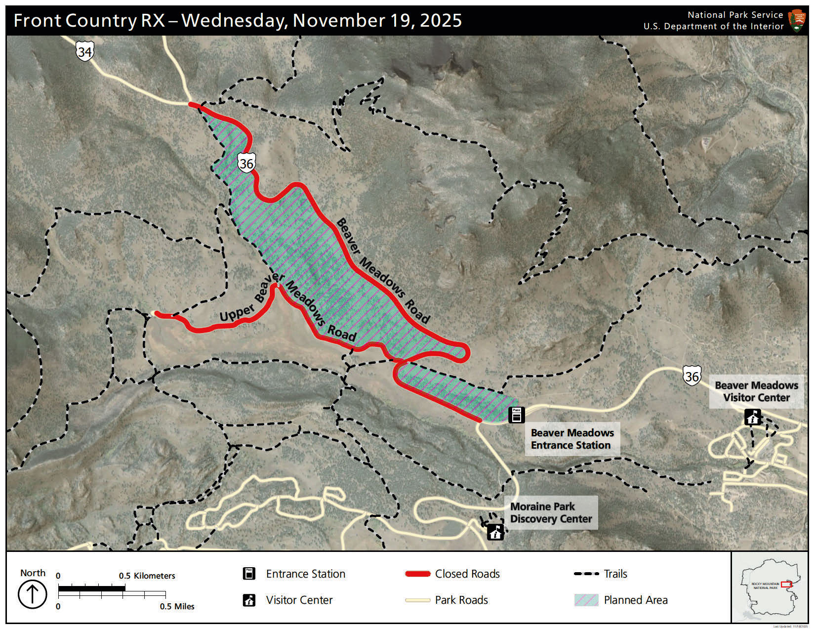
Based upon the potential for favorable weather and conditions, fire managers at Rocky Mountain National Park are planning to conduct a prescribed burn on Wednesday, November 19. Firefighters plan to burn up to 294 acres. This burn area is located inside Rocky Mountain National Park, west of Beaver Meadows Visitor Center and near Upper Beaver Meadows Road. Because of the fuel type that will be burned, which includes mainly grasses and small shrubs, heavy and prolonged smoke is not expected from this operation.
Due to the proximity of burn operations near the road, U.S. Highway 36 inside Rocky Mountain National Park will be temporarily closed from Deer Ridge Junction to Bear Lake Road Junction from 9 a.m. to 5 p.m. Beaver Meadows Entrance and Bear Lake Road will remain open. Interested in taking a scenic drive to Many Parks Curve? Visitors should plan to enter the park via Fall River Entrance/U.S. Highway 34.
The primary goal of the project is to reduce the threat of wildland fire to adjacent communities and NPS infrastructure by using prescribed fire to reduce the amount of fuels available in this area. When fighting the East Troublesome Fire in 2020 and the Fern Lake Fire in 2012, firefighters were able to take advantage of previous and existing prescribed fire and hazardous fuels treatment areas that provided a buffer between the fire and the town of Estes Park. Prior hazard fuels projects were instrumental in stopping the fire from jumping Bear Lake Road and Trail Ridge Road.
If conditions are favorable, ignitions are planned to occur on Wednesday, November 19. "With the anticipated weather this week, conditions are right to complete another section of the Front Country Prescribed Fire," said Nathan Hallam, Fuels Specialist for Rocky Mountain National Park. "Winds are expected to be enough to disperse smoke but not put containment lines at risk and precipitation later in the week will help extinguish any lingering heat after operations are complete." Firefighters will be on scene for the duration of the operation and will be patrolling the burned area. Smoke from the prescribed burn will be visible throughout the day of the burn, mostly during the warmest part of the day. With cooler temperatures in the evening, smoke may linger and accumulate in low-lying areas.
Additional information may be shared on InciWeb at https://inciweb.wildfire.gov/incident-information/cormp-front-country-prescribed-fire, on www.nps.gov/romo and on Rocky Mountain National Park’s official social media channels.
Smoke may be visible both inside and outside the park. Every effort will be made to minimize smoke impacts on visitors and the adjacent community; however, some smoke is anticipated to disperse east of the park. Smoke may affect your health: For more information see https://www.colorado.gov/pacific/cdphe/wood-smoke-and-health. For the safety of visitors and firefighters, park visitors will not be allowed to stop along U.S. Highway 36 near the burn area or walk within or near the burn area.
Safety factors, weather conditions, air quality, personnel availability and environmental regulations are continually monitored as a part of any fire management operation. For more information please contact the park’s Information Office at (970) 586-1206.
Last updated: November 18, 2025
