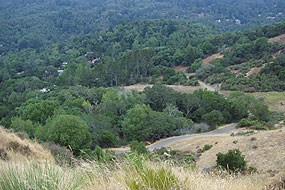
Cascade Canyon Fuel BreakCOMMUNITIES: Fairfax INTERFACE: Golden Gate National Recreation Area, Marin County Open Space District FIRE DISTRICT: Marin County Fire District FUNDING PROVIDED: $45,000 (FY 2003), $60,000 (FY 2004) OBJECTIVE: Reduce fuels and improve emergency access. DESCRIPTION: This project will provide a fuel break along existing fire roads as necessary to protect homes surrounding the Preserve, reduce fire hazards on public land, and provide a safer location for fire suppression agencies to take a stand by clearing understory shrubs, limbing up trees, and removing dead trees and other heavy fuels near the road. The Cascade Canyon Open Space Preserve consists of approximately 200 hectares (497 acres) and is located west of the town of Fairfax. The area contains occupied single and multi-family dwellings. The project area is served by narrow, paved roads that lead to single lane fire roads. NPS/FSM TASK AGREEMENT NO. 48 & 52 List of Projects | Top of Page Worn Springs Road Fuel Reduction and Fuelbreak ConstructionCOMMUNITIES: Fairfax - San Anselmo INTERFACE: Marin Municipal Water District and Marin County Open Space District FIRE DISTRICT: Marin County Fire Department FUNDING PROVIDED: $50,000 (FY 2004) OBJECTIVE: To improve fire safety and readiness around suburban towns in central Marin on the lower slopes of Mount Tamalpais. DESCRIPTION: This plan will coordinate the planning and implementation to remove ladder fuels, and remove additional hazardous fuels to construct a fuel management zone on 4 hectares (10 acres) of interface boundary along Worn Springs Road. The construction of a fuel management zone will consist of: removing all non-native French broom and select native shrubs to reduce surface fuels; thinning overstocked stands of trees; pruning low tree branches (ladder fuels); collecting, piling, and burning accumulated down, wood material; and clearing along principal access routes. Fairfax and San Anselmo are suburban towns in central Marin on the lower slopes of Mt. Tamalpais. Nearly 20,000 people inhabit this community. The residential area is characterized by steep topography, heavy overgrown wildland fuels and significant exposures thus complicating the threat of a wildfire. Along these steep-sloped canyons, narrow winding roads lead to expensive homes, surrounded by highly flammable, overgrown vegetation. NPS/FSM TASK AGREEMENT NO. 54 |
Last updated: January 26, 2024

