Last updated: May 16, 2025
Place
Hågat (Agat) Beach
National Archives 80-G-243796
Quick Facts
Location:
9MP5+Q75, Hågat, Guam
Significance:
Southern landing site during the Battle of Guam
The plan to recapture Guam called for two simultaneous landings on July 21, 1944 – W-Day. While the Third Marines landed at Assan Beach, the 1st Provisional Marine Brigade, led by Brigadier General Lemuel C. Shepherd, attacked Hågat (Agat) Beach, five miles to the south. Once the beachhead was established, the Marines would cut off the strategic Orote Peninsula, which jutted into the Philippine Sea between the two landing sites, and link up with the Third Marines at Assan. [1]
The Battle Begins
Hågat Beach lay on Guam's southeast coast. It stretched for more than a mile between Bangi Point in the south and the old village of Hågat in the north, with Ga'an Point, a rocky coral outcrop, roughly in the middle. A quarter mile offshore, a wide reef which had been seeded with more than 300 mines and coral-filled wooden cribs held together by wire protected the beaches. [2]
Despite two weeks of heavy bombing leading up to the invasion, the Imperial Japanese 38th Infantry Regiment, led by Colonel Tsunetaro Suenaga, still had intact gun emplacements defending Hågat. As the first wave of LVTs approached the beach the morning of July 21, 1944, mortar, artillery, and machine-gun fire rained down on them from concealed weapons on the beach and the ridges towering over the thin strip of sand, but despite the fierce gunfire, the first assault wave of the 1st Brigade landed on Hagat at 8:32 a.m. [3]
The battle for the southern beachhead had begun.
Establishing the Beachhead
Hågat was divided into four sections: Beaches Yellow 1 and 2 to the north of Ga'an Point and Beaches White 1 and 2 to the south. The 22nd Marines landed on the Yellow Beaches, where they met the fiercest resistance of the day. As the 2nd Battalion, 22nd Marines' Amtracs rumbled ashore, Imperial Japanese defenders in two bunkers built into the tip of Ga'an Point opened fire with 75mm and 37mm guns, destroying more than a dozen Amtracs and killing seventy-five Marines before they could reach dry land. Marine Raymond G. Schroeder of the 22nd Marines described the Beach Yellow 2 landing:
We lost 75 men in an area the size of a football field, most of them in the first 10 minutes, ... and for every dead man, there are always two to three wounded. ... We were at point blank range, no place to go except straight ahead.[4]
The strongholds, which can still be seen at the Agat Unit of War in the Pacific National Historical Park, had been mistaken for palm tree-covered sand dunes in the pre-invasion reconnaissance and therefore not bombed in advance. They posed a major problem for the first few hours of W-Day before a group of tanks circled around behind the bunkers, catching the defenders by surprise and killing them. [5]
The 4th Marines landed south of Ga'an Point, on Beaches White 1 and White 2. Once ashore, the 1st Battalion swung right and captured Bangi Point, but ran into serious opposition at Hill 40, a low hill rising roughly forty to sixty feet high above the road parallelling the beach. The hill had a strategic view of the landing beaches and had been heavily armed with machine guns. It took several hours and the support of two Sherman tanks before it was finally captured. [6]
At the end of W-Day, the southern beachhead was 4,500 yards long and 2,000 yards deep. The village of Hågat, which had been reduced to rubble by the pre-invasion bombardment, was in American hands; roadblocks were set up on Harmon Road, which led straight into the heart of the landing beach; and the 4th Marines had reached the base of Mt. Alifan. General Shepherd reported:
Own casualties about 350. Enemy unknown. Critical shortage fuel and ammunition all types. Think we can handle it. Will continue as planned tomorrow.[7]
Despite the day's progress, the 1st Brigade's position was far from secure. The lines were stretched thin and most of the reserve troops were still not ashore. The Marines only held the first few ridges, while the Japanese still controlled the high ground overlooking the landing beaches. The American position was vulnerable to a nighttime counterattack, a favorite tactic of the Imperial Japanese Army. [8]
Midnight Counterattack
Despite having taken heavy losses during W-Day, Suenaga asked Lieutenant General Takeshi Takashina, commander of the Japanese forces on Guam, for permission to launch a counterattack the night of July 21. Takashina reluctantly agreed. Suenaga himself seemed doubtful of success. Before the attack began, he ordered that the regiment's colors be burned to prevent them from being captured. [9]
At 11:30 p.m., Imperial Japanese soldiers launched probing attacks all along the 1st Brigade's line. Hill 40, which had been hotly contested during the day, was a focal point of the attack. 750 Imperial Japanese soldiers attacked the hill, which was held by the 200 men of Company K, 3rd Battalion, 4th Marines. The Marines lost possession of the hill around 1:00 in the morning, then retook it, only to be driven back a second time. They attacked again, this time with reinforcements, and once again retook the hill, this time holding it. At dawn, Hill 40 was in American hands. Nearly all the Japanese attackers were dead. [10]
At 2:30 a.m., four Japanese tanks followed by trucks mounted with guns rumbled down Harmon Road. Wielding a bazooka, Private First Class Bruno Oribiletti of 2nd Battalion, 4th Marines single handedly took out two Japanese tanks before being killed. A platoon of Sherman tanks blasted the remaining tanks and truck-mounted guns, forcing the Japanese to retreat. For his bravery, Oribiletti was awarded the Navy Cross. [11]
The Japanese attack continued through the night. Colonel Suenaga himself led an attack on the 4th Marines' right flank but was killed during the fighting. While the sky was lit with a constant barrage of naval gunfire and mortars, groups of infiltrators still slipped past American's lines. A squad of fourteen Japanese soldiers armed with explosives nearly reached the brigade's ammunition dump but were fought off by the 4th Marine Ammunition Company, an all-Black unit. Explosive-laden infiltrators even made it to the beach road, where they disabled two weapons carriers and three of the critical LVTs before being killed. [12]
While brave, Suenaga's counterattack was a failure. When the sun rose on July 22, the Marines' line had held, while the 38th Regiment had effectively ceased to exist. At least fifty Marines were killed during the night, and another hundred were wounded, but over 600 Imperial Japanese soldiers had also died. [13]
Securing the Forced Beachhead Line
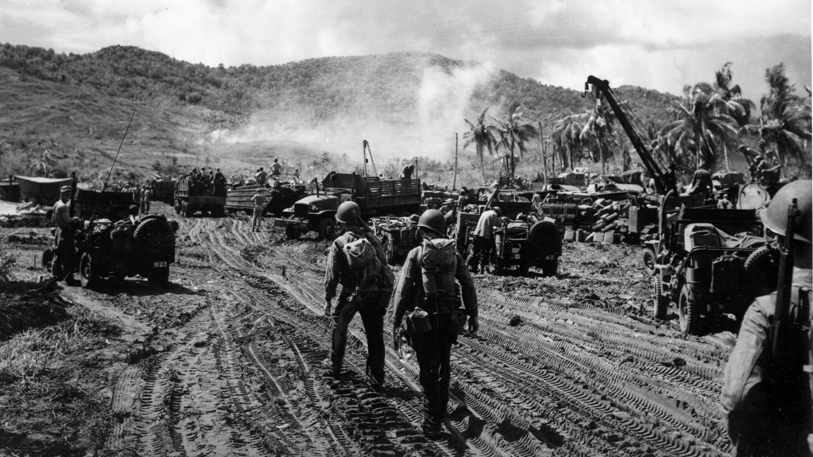
With the beach in American hands and the reserve troops coming ashore, Shepherd ordered his troops to move out the morning of July 22. The 305th Regiment, 77th U.S. Army Infantry Division relieved the 4th Marines, freeing them to capture Mount Alifan. By July 23, the infantrymen had secured the Forced Beachhead Line (FBL or FBHL), or the perimeter needed to provide a secure area to land troops and supplies. [14]
The 22nd Marines, meanwhile, moved north along the coast to block the entrance to Orote Peninsula, home to an airfield and the entrance to Apra Harbor. They faced only scattered resistance until they reached the narrow entrance of Orote Peninsula, an area full of rice paddies interspersed with small hills. The heavy losses the Imperial Japanese 38th Infantry suffered during the counterattack meant they could no longer fight the Americans on all fronts. Instead, they mustered their remaining forces for one final stand. Gun emplacements hidden on the backside of the hills easily pinned down advancing Marines, who sunk hip-deep into the muddy water. The 22nd Marines suffered over 100 casualties as they tried and failed to advance on the afternoon of July 23.
Unable to move through the Japanese strongpoint, the 22nd Marines instead outflanked it. The following morning, after a lengthy bombardment by air and naval gunfire, the 1st and 3rd Battalions charged north up the Hågat-Sumai Road as it ran through a narrow corridor between the coast and the fortified rice paddies. Once clear of the rice paddies, the 1st Battalion continued across the narrow stretch of land at the neck of Orote Peninsula, while the 3rd Battalion quickly veered right to destroy the Japanese guns before also heading north towards Apra Harbor. By nightfall, the 1st Battalion had reached their target, while the 3rd Battalion was just 400 yards shy of it.
Meanwhile, the 2nd Battalion advanced southeast of the rice paddies on the Old Hågat Road. With all attention on the Marines on the Hågat-Sumai Road, they encountered almost no resistance and were able to easily cut across land west of the rice paddies to reach Apra Harbor and capture the village of Atantano. [15]
By the evening of July 24, after four days of hard fighting, the southern beachhead was firmly established. The 22nd Marines had the Imperial Japanese troops in Orote Peninsula bottled up, the 77th Division was dug-in at the FBL, and supplies were steadily coming ashore on Hågat Beach. However, victory came at a high price. The 1st Brigade reported 188 men killed in action, 728 wounded in action, and 87 missing in action. The 77th Division lost 12 men and had 20 wounded, and the Navy lost 15 men, with another 50 wounded. The 1st Brigade conservatively estimated that 1,776 Japanese soldiers had been killed. [16]
View historic photos of Hågat Beach during the Battle of Guam.
[1] Maj O. R. Lodge, The Recapture of Guam (Headquarters: Historical Branch, G-3 Division, U.S. Marine Corps, 1954), 47–48; Robert F. Rogers, Destiny's Landfall: A History of Guam, Revised Edition (Honolulu: University of Hawaiʻi Press, 2011), 170–72; Henry I. Shaw, Bernard C. Nalty, and Edwin T. Turnbladh, Central Pacific Drive, vol. III, History of U.S. Marine Corps Operations in World War II (Headquarters: Historical Branch, G-3 Division, U.S. Marine Corps, 1966), 500–501.
[2] Harry A. Gailey, The Liberation of Guam, 21 July-10 August 1944 (Novato, CA : Presidio, 1988), 87, 99; Vida Germano and James Oelke Farley, "War in the Pacific National Historical Park: Cultural Landscapes Inventory, National Park Service" (NPS Pacific West Regional Office, 2013), 35; Lodge, The Recapture of Guam, 48; Peggy Nelson, Lisa Duwall, and Laila Tamimi, "Asan and Agat Invasion Beaches: Cultural Landscape Inventory, War in the Pacific National Historical Park, National Park Service" (National Park Service, November 26, 2003), 47; Shaw, et al, Central Pacific Drive, 452.
[3] Russell A. Apple, "Guam: Two Invasions and Three Military Occupations" (Mangilao, Guam: Micronesian Area Research Center of the University of Guam, 1980), 56–59; Gailey, The Liberation of Guam, 99; Lodge, The Recapture of Guam, 48; Shaw, et al, Central Pacific Drive, 472.
[4] Dave Lotz and Rose S.N. Manibusan, "Liberating Guam," in LIBERATION — Guam Remembers: A Golden Salute for the 50th Anniversary of the Liberation of Guam, 1994.
[5] Gailey, The Liberation of Guam, 100–102; Lodge, The Recapture of Guam, 48–50; Nelson, Duwall, and Tamimi, "Asan and Agat Invasion Beaches: Cultural Landscape Inventory," 46–52; Cyril J. O'Brien, Liberation: Marines in the Recapture of Guam, Marines in World War II Commemorative Series (History and Museums Division, Headquarters, U.S. Marine Corps, 1994), 11–13; Rogers, Destiny's Landfall, 172; Shaw, et al, Central Pacific Drive, 472–74.
[6] Gailey, The Liberation of Guam, 99–102; Guam Inventory Team, "Hill 40," National Register of Historic Places Registration Form (Honolulu, Hawai'i: Bernice P. Bishop Museum, 1975); Lodge, The Recapture of Guam, 51–53; O'Brien, Liberation: Marines in the Recapture of Guam, 13–15; Shaw, et al, Central Pacific Drive, 475–76; Erwin N. Thompson, "War in the Pacific National Historical Park Historic Resource Study," Historic Resource Study (National Park Service, July 1985).
[7] Shaw, et al, Central Pacific Drive, 476.
[8] Gailey, The Liberation of Guam, 100–103; Lodge, The Recapture of Guam, 49–53; Shaw, et al, Central Pacific Drive, 473–76.
[9] Gailey, The Liberation of Guam, 102–4; Lodge, The Recapture of Guam, 54–56; O'Brien, Liberation: Marines in the Recapture of Guam, 17–18; Shaw, et al, Central Pacific Drive, 476–80.
[10] Gailey, The Liberation of Guam, 104; Guam Inventory Team, "Hill 40"; Lodge, The Recapture of Guam, 54; O'Brien, Liberation: Marines in the Recapture of Guam, 17–18; Shaw, et al, Central Pacific Drive, 480–82.
[11] Gailey, The Liberation of Guam, 105; Lodge, The Recapture of Guam, 55; O'Brien, Liberation: Marines in the Recapture of Guam, 18; Shaw, et al, Central Pacific Drive, 483.
[12] Gailey, The Liberation of Guam, 104–5; Lodge, The Recapture of Guam, 55–56; Bernard C. Nalty, The Right to Fight: African-American Marines in World War II, Marines in World War II Commemorative Series (Washington, D.C: History and Museums Division, U.S. Marine Corps, 1995); O'Brien, Liberation: Marines in the Recapture of Guam, 17–18; Shaw, et al, Central Pacific Drive, 482.
[13] Gailey, The Liberation of Guam, 105–6; Guam Inventory Team, "Hill 40," 40; O'Brien, Liberation: Marines in the Recapture of Guam, 18; Shaw, et al, Central Pacific Drive, 483–84.
[14] Gailey, The Liberation of Guam, 115–19; Lodge, The Recapture of Guam, 66–67; Rogers, Destiny's Landfall, 173; Shaw, et al, Central Pacific Drive, 494–96.
[15] Gailey, The Liberation of Guam, 115–19; Lodge, The Recapture of Guam, 65–69; Rogers, Destiny's Landfall, 173; Shaw, et al, Central Pacific Drive, 493–500.
[16] Gailey, The Liberation of Guam, 121; Lodge, The Recapture of Guam, 69–70; Nelson, Duwall, and Tamimi, "Asan and Agat Invasion Beaches: Cultural Landscape Inventory," 52; Shaw, et al, Central Pacific Drive, 501.