An official website of the United States government
Here's how you know
Official websites use .gov A
.gov website belongs to an official government
organization in the United States.
Secure .gov websites use HTTPS A
lock (
) or https:// means you've safely connected to
the .gov website. Share sensitive information only on official,
secure websites.
Download and print a map of Pinnacles National Park before you arrive. In addition to the visual brochure map, the park's official brochure is available in a variety of formats including text-only and audio-only.
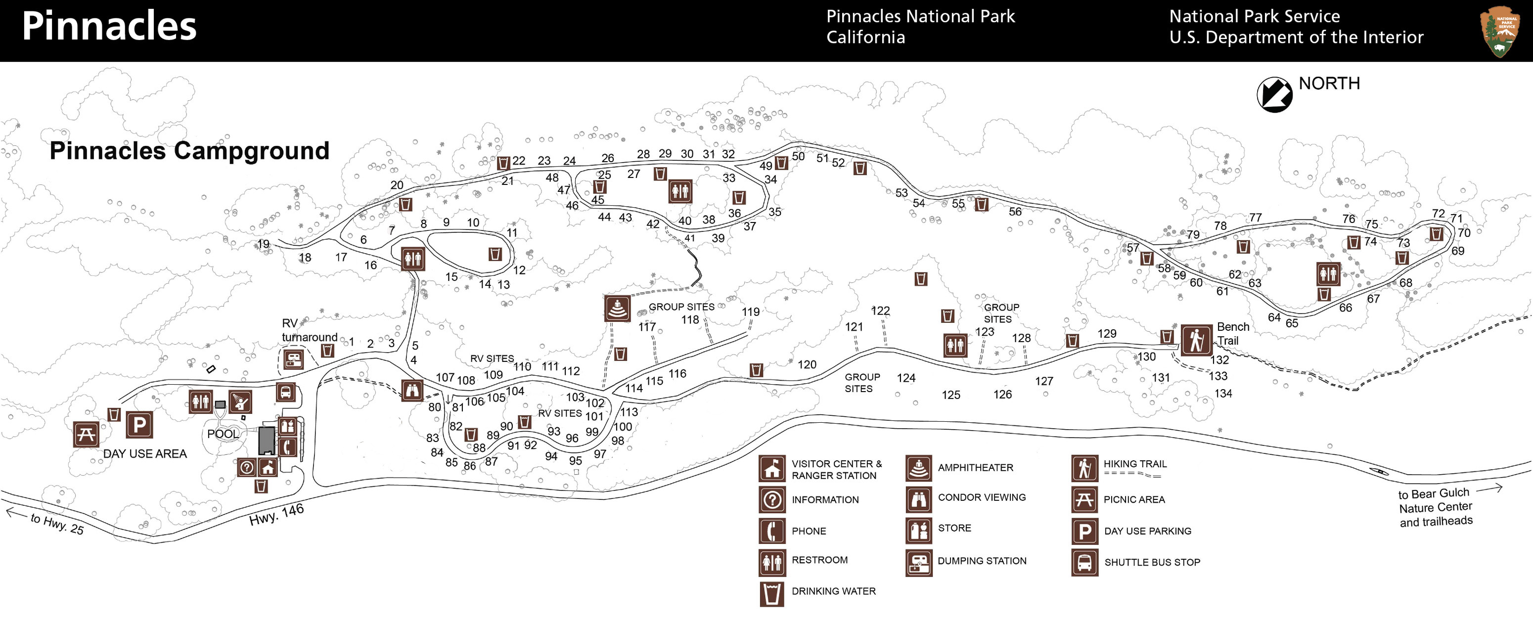
Pinnacles Campground Map
Pinnacles Recreation Co.
Pinnacles Campground is located at the East entrance off of Highway 25 from Hollister, CA (North) and King City, CA (South). Click the link to view a map of the campground. Reserve your site at recreation.gov.
2020 Pinnacles National Park Map - Cropped
NPS
(Click on the map to enlarge the image) In the High Peaks area, most of the park's trails navigate the Pinnacles formation at the heart of the park. Pay close attention to distances and signage as many trails intersect and connect making rewarding yet complex loops. Triple check your route at every intersection.
2024 Pinnacles National Park Map
NPS Photo
Click for a larger view of the map.
2024 Pinnacles National Park Map Trail Recommendations
NPS Photo
Alt. Text Image Description:
Explore Pinnacles
NO ROAD CONNECTS THE WEST AND EAST ENTRANCES OF THE PARK. The
shortest route from one side to the other is through King City on US 101 (see inset map). Find
lodging, camping, food, and gas in nearby towns. In the park, camp only in the designat- ed
campground.
WEST SIDE
Entrance open 7:30 am to 8 pm. Take US 101 to CA 146 and follow signs to the park.
WARNING: CA 146 from Soledad is steep and narrow. RVs, trailers, and large vehicles should avoid
this entrance.
WEST VISITOR CONTACT STATION Find
exhibits, information, a film, and a bookstore. Open yearround. Schedule varies; check the website.
EAST SIDE
Entrance open 24 hours; no overnight parking except in campground. Take CA 25 to East Entrance
Road.
BEAR GULCH NATURE CENTER Find ex-
hibits, information, and a film. Open seasonal- ly. Schedule varies; check the website.
PINNACLES CAMPGROUND Open year-
round. The campground has tent, RV, and group sites; tent cabins; hookups; and showers. Reserve at
www.recreation.gov or call 877-444- 6777. For information call 831-200-1722.
STORES Camp store: Open 9:30 am to 5 pm daily. Park store: Find books, maps, education- al
souvenirs, and more. Schedule varies; check the website.
ACTIVITIES
Some of the park’s most popular activities are listed here. Check the website for more things to
do.
BIRDING Over 180 species are found here. Look for California condors and peregrine and prairie
falcons in the High Peaks area.
CAVE EXPLORATION
Balconies and Bear Gulch caves offer a respite from the heat. Be prepared for low ceilings, uneven
footing, and scrambling over rocks.
Use a flashlight or headlamp. Bear Gulch Cave is closed seasonally to protect bat colonies.
Check the website for current closures. CLIMBING Explore hundreds of climbing routes from easy to
extremely difficult. Check the website for safety and general information.
Use climbing guides for route descriptions and grades.
RANGER PROGRAMS Programs are offered seasonally. Check the website for schedules. ACCESSIBILITY We
strive to make facilities, services, and programs accessible to all. For information go to the
contact station or nature center, ask a ranger, call, or check the park website.
SAFETY AND REGULATIONS
Be prepared. Cell phone service is limited. In summer and fall daytime temperatures can reach over
100°F. Check the website for more safety information and regulations. Carry and drink plenty of
water. • Wear loose-fitting clothing, a hat, and sunscreen. • Wear sturdy, non-slip shoes or boots
with ankle support. • Be careful where you sit, step, and place your hands: Poison oak, stinging
nettles, and rattle- snakes are found here. • Pets and bicycles
are prohibited on all trails. • Feeding, ap- proaching, or hunting wildlife is prohibited.
• Federal laws protect all natural and cultural features in the park. • For firearms regulations
check the park website. • Using remotely piloted aircraft like drones is prohibited. Pinnacles
National Park has more than 30 miles of trails that showcase the beauty of the park up close and
personal. Hikes range from flat stretches of grasslands to uphill climbs through talus caves onward
to the rocky spires that Pinnacles is famous for. If you are new to the park, consult with a ranger
at the Pinnacles Visitor Center, the Bear Gulch Nature Center, or the West Pinnacles Visitor
Contact Station.
They can provide advice about trails, as well as recommendations for different fitness and
experience levels.
Always take plenty of water for each person in your group.
Bring a flashlight if your hike leads through a cave.
Trails from Pinnacles Campground Pinnacles Visitor Center to Bear Gulch Day Use Area
2.3 miles one way, 1-1/2 hours Elevation: 300 feet
Moderate
Walk along Chalone and Bear creeks from the Pinnacles Visitor Center to the Bear Gulch Day
Use Area. A section of the Bench Trail between Peaks View and South Wilderness Trail may be
accessible to visitors in wheelchairs.
Pinnacles Visitor Center to South Wilderness Trail
6.5 miles round trip, 3 to 4 hours Elevation: no gain
Moderate
Follow this unmaintained trail to the park boundary, or simply meander through the magnificent
grove of valley oaks. Begin at the campground and follow the Bench trail to the South Wilderness
marker. This trail is an excel- lent choice for bird and other wildlife viewing.
Pinnacles Visitor Center to Balconies Cave
9.4 miles round trip, 4 to 6 hours
Elevation: 300 feet Moderate
Hike along sunny Chalone Creek on the Bench and Old Pinnacles trails to Balconies Cave. On the
return trip, cross over the cave via the Bal- conies Cliffs trail for views of the largest rock
formations in the park. Flashlight required in the cave.
Trails from Bear Gulch Day Use Area Moses Spring to Rim Trail Loop
2.2 miles round trip, 1 to 1 and ½ hours Elevation: 500 feet
Moderate
This loop is a good choice for rock forma- tions, talus caves, and the reservoir on a short hike
and also a good choice for children. Bear Gulch Cave is open seasonally. Flashlight re- quired in
the cave.
Condor Gulch to High Peaks Loop
5.3 miles round trip, 3 to 5 hours
Elevation: 1,300 feet Strenuous
Walk through the heart of the Pinnacles rock formations, particularly along the Steep and Narrow
section of the High Peaks trail. Add the Rim and Moses Spring trails to extend the loop to 6.1
miles.
High Peaks to Bear Gulch Loop
6.7 miles round trip, 4 to 5 hours
Elevation: 1,425 feet
Strenuous
Climb into the High Peaks and descend along the ridge through meadows of grasses and, in the
Spring, wildflowers. Return to the Bear Gulch Day Use Area under the shade of syca- more, buckeye,
and Oak trees along the Bench and Bear Gulch trails.
Condor Gulch Trail
1.7 miles one way, 1 to 1-1/2 hours Elevation: 1,100 feet
Moderate to Overlook, Strenuous beyond This trail offers spectacular views of the High Peaks,
whether you hike just a few minutes or
the entire trail. Condor Gulch Overlook is only one mile up the trail.
Chalone Peak Trail
9 miles round trip, 3 to 5 hours
Elevation: 2,040 feet Strenuous
Climb to the highest point in the monument, North Chalone Peak, and be rewarded with views of the
surrounding valleys. Continue on an unmaintained trail to South Chalone Peak for a longer hike.
Trails from Old Pinnacles Trailhead Old Pinnacles Trail to Balconies Cave
5.3 miles round trip, 3 to 5 hours Elevation: none
Moderate
This sunny hike to Balconies Cave also leads to towering rock formations: Machete Ridge and the
Balconies Cliffs. Begin at the Old Pinnacles Trailhead. Flashlight required in the cave.
Trails from West Pinnacles Contact Station Prewett Point Trail
0.9 miles round trip, 1/2 to 1 hour Elevation: 70 feet
Easy
A gently hike with great views of the Hain Wil- derness. The stabilized trail is 5 feet wide for
0.4 miles to the largest overlook. Between the largest overlook and the trail junction (coun-
terclockwise) it is 3 feet wide for 0.25 miles. There is little shade, and the sun can be intense
in the late morning and afternoon.
Jawbone Trail
1.2 miles one way, 1/2 to 1 hour Elevation: -560 feet
Easy to Moderate
The Jawbone Trail leads northeast from the Prewett Point Trail, descending to the Jawbone Parking
Area. From there it connects to the Chaparral Parking Area (0.3 miles).
Trails from Chaparral (West Pinnacles) Balconies Cliffs-Cave Loop
2.4 miles round trip, 1 to 1-1/2 hours Elevation: 100 feet
Easy to Moderate
This trail crosses up and over the Balconies Cave, then descends back down to the Old Pinnacles
trail, which leads back through the cave. Scramble through the talus passages of the Balconies
Cave. Wading may be necessary in the winter when precipitation creates flood- ing. Flashlight
required in cave.
Juniper Canyon Loop
4.3 miles round trip, 2 to 3 hours
Elevation: 1,215 feet Strenuous
This steep trail climbs along switchbacks to the heart of the High Peaks. At the top, circle
through the rock formations along the Steep and Narrow section of the High Peaks Trail and begin
the descent down on the Tunnel Trail.
North Wilderness Trail Loop
9.3 miles round trip, 5 to 8 hours
Elevation: 1,020 Strenuous
This unmaintained trail climbs along the ridge tops and then descends into the Chalone Creek bed,
where it is marked by rock cairns. Return along the Old Pinnacles and Balconies Trail.
High Peaks to Balconies Cave Loop
8.4 miles round trip, 4 to 5 hours
Elevation: 1,540 feet Strenuous
Begin by climbing into the High Peaks, and the rest of the loop is downhill or flat. Return along
the Old Pinnacles and Balconies trails, going over or through the cave. Flashlight
required in the cave.
Last updated: January 30, 2025
Park footer
Contact Info
Mailing Address:
5000 East Entrance Road
Paicines,
CA
95043
Phone:
831 389-4486
Please call the number above for all park related inquiries. For camping questions contact the Pinnacles Campground at (831) 200-1722. For the park store, please call (831) 389-4485.


