Submerged Cultural Resources Study:
USS Arizona and Pearl Harbor National Historic Landmark

|
USS ARIZONA MEMORIAL Submerged Cultural Resources Study: USS Arizona and Pearl Harbor National Historic Landmark |
|
|
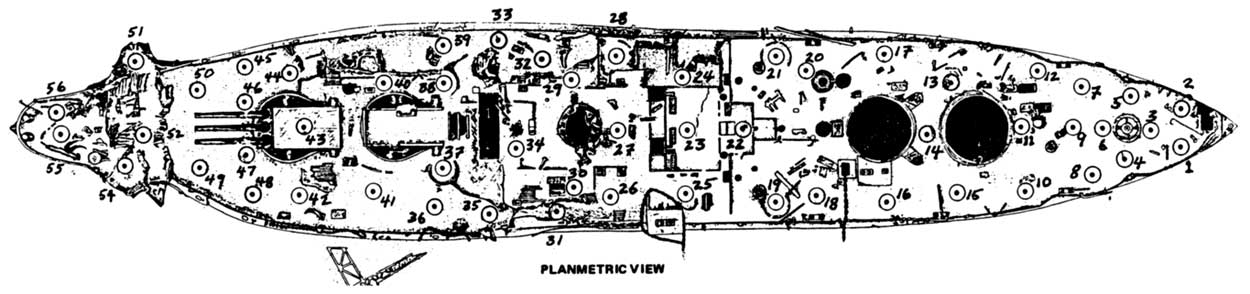
Chapter IV: Biofouling And Corrosion Study Sedimentation and Condition of Horizontal Surfaces Methods Fifty-five locations on horizontal surfaces of the ship were marked for examination of sediment type and depth (Figure 4.7). Because most of the ship's superstructure had been removed in the salvage operations, most of the study stations had to be situated over main deck surfaces, primarily of teak wood. Station depths ranged from 5 to 18 feet.
Horizontal stations were marked with 2-1/2-inch squares of 1/8-inch plexiglass on which station numbers had been engraved using a hot soldering iron tip. Each plexiglass number tag was glued onto the top of a 6-inch-long piece of 1-inch-diameter PVC pipe, and the opposite end of the pipe was secured to the flat side of a square 3-pound lead diver's weight with a plastic electrical tie. The number tags were painted with antifouling paint to ensure readability of the station numbers for two to three years. The markers were placed on sediment surfaces with tags facing upward. At some stations where sediments consisted of deep mud, 1-foot squares of plexiglass were placed under the lead weights to keep them from sinking into the mud. After horizontal stations were marked, a pair of divers visited those stations and observed sediment character and underlying deck conditions. To determine sediment thickness, a 3-foot-long, 3/8-inch-diameter steel rod was pushed into the sediment until hard substrate was encountered. The size, spectrum and type of sediment particles present were noted, and observations were recorded on the type and abundance of biota present, such as mat-forming tube worms and sponges. Where sediment thicknesses were less than about 1 foot, holes were dug to expose small patches of underlying deck. Composition of the exposed deck areas was determined visually, and the corrosion or decomposition state of that material was noted. Holes were filled in when observations were completed. Close-up photographs (color slides taken with 3:1 lens) were taken of typical sediment surfaces on horizontal surfaces. Copies of those slides are on file with NPS Arizona Memorial.
http://www.nps.gov/usar/scrs/scrs4c.htm Last Updated: 27-Apr-2001 |