USS ARIZONA MEMORIAL
Submerged Cultural Resources Study:
USS Arizona and Pearl Harbor National Historic Landmark
NPS Arrowhead logo


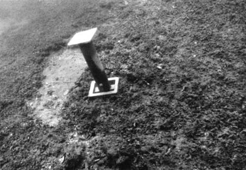
Chapter IV: Biofouling And Corrosion Study
(continued)


Sedimentation and Condition of Horizontal Surfaces

Results

Descriptions of sediment, biota and underlying surfaces observed at the horizontal stations are presented in Table 4.4. Four distinct zones of differing sediment types were delineated:


Table 4.4. Horizontal stations, USS ARIZONA, descriptions of sediment, biota and underlying surfaces.

Station 1
Sediment 1-2" deep. Sandy rubble held together in spongy mat by Branchiomma and sponges. Branchiomma very abundant and sponges in about 20% planar coverage. Sediment about 10% silt, 50% sand, 20% rubble and 20% Branchiomma tubes and burrowing sponges. About 3 sabellids (large feather duster worms) per sq. m.

Smooth teak under sediment.

Station 2
Sediment 3/4-1" deep. Sediment same as station 1.

Teak with burrow holes and some coverage of hard fouling.

Station 3
Sediment 2 1/2" deep. Sediment same as station 1.

Smooth teak under sediment.

Station 4
Sediment 4" deep. Sediment same as station 1.

Smooth teak under sediment.

Station 5
Sediment 2 1/2" deep. Sediment same as station 1.

Smooth teak under sediment.

Station 6
Sediment 3" deep. Sediment same as station 1.

Smooth teak under sediment.

Station 7
Sediment 3/4-1 1/2" deep. Sediment same as station 1.

Teak with some burrows under sediment.

Station 8
Sediment 4-5" deep. Sediment same as station 1.

Smooth teak under sediment.

Station 9
Sediment 4 1/2" deep. Sediment same as station 1.

Smooth teak under sediment.

Station 10
Sediment 4 1/2" deep. Sediment same as station 1.

Smooth teak under sediment.

Station 11
Sediment 4-12" deep. Sediment same as station 1.

Surface below sediment is irregular, corroded metal and hard fouling.

Station 12
Sediment 1 1/2-2 1/2" deep. Sediment same as station 1.

Smooth teak under sediment.

Station 13
Sediment 6" deep. Sediment same as station 1.

Smooth teak under sediment.

Station 14
Sediment 10-13" deep. Overlying sediments same as station 1, but at 3" depth sediment grades into coarse rubble (largely oyster shells and vermetid worm tubes) admixed with silt and sand.

Surface under sediment felt like wood, but could not see surface because of turbidity in hole.

Station 15
Sediment 5" deep. Sediment same as station 14.

Smooth teak under sediment.

Station 16
Sediment depth exceeded 18" probe length. Sediment same as station 14.

Surface beneath sediment in nearby area felt like wood from probe contact.

Station 17
Sediment 4" deep. Sediment same as station 14, but burrowing sponges more abundant.

Smooth teak under sediment.

Station 18
Sediment 5-7" deep. Sediment 60% silt/mud, 20% rubble. 10% sand and 10% sponges. Snapping shrimp burrows present.

Surface below sediment not observed.

Station 19
Sediment 9-10" deep. Sediment 75% rubble with sand and wilt admixed. Abundance of sponges in sediment.

About 10% of sediment surface covered with erect "finger" and "ball" sponges. Branchiomma uncommon here.

Surface below sediment not observed.

Station 20
Sediment 7-8" deep. Sediment 40% Branchiomma, 20% sponges, 15% rubble, 10% and, and 15% silt/mud.

Teak under sediment. Condition not noted.

Station 21
Sediment 9" deep. 50% rubble, 20% sponges, 10% Branchiomma tubes, 10% sand, and 10% silt/mud.

Surface under sediment not observed.

Station 22
Sediment 3-6" deep. Sediment same as station 21.

Surface under sediment is corroded metal.

Station 23
Sediment 5" deep. Sediment 60% rubble (40% oyster shells, 20% vermetid tubes, some coins and porcelain fragments), 15% mud/silt, 15% sand, 5% sponges and 5% Branchiomma.

Surface under sediment is porcelain tile in good condition.

Station 24
Sediment 5-10" deep. Sediment 50% rubble, 25% silt/mud, and 25% sand. snapping shrimp and commensal goby fish present.

Surface under sediment not observed.

Station 25
Sediment 4-6" deep. Sediment 80% rubble with some very large (4-8" diameter) on surface. Some 50 caliber bullets seen on sediment surface. About 5 sabellids per meter square. Branchiomma rare. Some solitary tunicates on sediment surface.

Surface under sediment is corroded metal that is exfoliating in 2-4" flakes that are about 1/8" thick.

Station 26
Sediment 1-4" deep. Sediment 75% rubble, 10% mud and sand, 10% sponges, and 5% Branchiomma.

Unidentified hard surface under sediment is overlain by at least 1" of black, "crusty" tar-like substance.

Station 27
Sediment 3-4" deep. Sediment similar to station 23. Some surface and burrowing sponges (about 1-2% of sediment surface).

Surface under sediment is heavily corroded metal that is reddish brown and black in color and is overlain by the same tar-like substance described above.

Station 28
Sediment 2-3" deep. Sediment 70% rubble, 10% mud/silt, 5% sand, and 15% sponges.

Surface under sediment similar to station 27.

Station 29
Sediment 10" deep. Sediment 90% rubble with some sand and very little silt/mud in upper layers. Fines concentrated deeper in sediment. Five sabellids per square meter.

Surface under sediment is corroded metal.

Station 30
Sediment 4-7" deep. Sediment 70% rubble, 10% sand, 10% sponges, and 10% silt/mud.

Surface under sediment is grey steel overlain by tar-like substance.

Station 31
Sediment 1-9" deep. Sediment similar to station 30.

Surface under sediment is grey steel overlain by tar-like substance.

Station 32
Sediment 3-9" deep. Sediment similar to station 30.

Surface under sediment is grey steel

Station 33
Sediment 8-16" deep. Sediment 50% rubble, 20% sponges, 20% Branchiomma. and 10% silt/mud/sand.

Surface under sediment not observed.

Station 34
Sediment 5-11" deep. Sediment 70% rubble, 10% sponges, 10% Branchiomma, and 10% sand/silt/mud.

Surface under sediment not observed.

Station 35
Sediment 3-20" deep. Sediment 50% rubble, 30% Branchiomma, 10% sponges, and 10% sand/silt/mud.

Surface under sediment is grey steel.

Station 36
Sediment 11-18" deep. Sediment similar to station 35.

Surface under sediment not observed.

Station 37
Sediment 21-24" deep. Sediment 50% rubble, 20% sponges, 10% Branchiomma, and 10% sand/mud.

Surface under sediment not observed.

Station 38
Sediment 9-15" deep. Sediment 60% rubble, 15% sand, 10% silt, and 15% sponges. No Branchiomma were noted there.

Surface under sediment not observed.

Station 39
Sediment 17-37" deep. Sediment 95% mud/silt and 5% sand.

Surface under sediment not observed.

Station 40
Sediment 12-17" deep. Sediment 50% Branchiomma, 25% mud/sand, 15% sponges, and 10% rubble.

Surface under sediment not observed.

Station 41
Sediment 24" to over 36" deep. Sediment 60% rubble, 10% Branchiomma, 20% sponges, 10% sand/silt/mud.

Surface under sediment not observed.

Station 42
Sediment 7-11" deep. Sediment 80% silt/mud, 15% rubble, and 5% sand.

Surface under sediment not observed.

Station 43
Sediment 1-2" deep. Sediment 70% Branchiomma, 10% sponges, 10% sand, and 10% mud/silt.

Surface under sediment is steel (armor plate) covered with a thin blackish finish.

Station 44
Sediment more than 36" deep. Sediment 90% silt/mud and 10% sand.

Surface under sediment not observed.

Station 45
Sediment more than 36" deep. Sediment 90% silt/mud, 5% rubble, and 5% sand.

Surface under sediment not observed.

Station 46
Sediment more than 36" deep. Sediment same as station 45.

Surface under sediment not observed.

Station 47
Sediment more than 36" deep. Sediment same as station 45.

Surface under sediment not observed.

Station 48
Sediment 39" deep. Sediment same as station 45.

Surface under sediment not observed.

Station 49
Sediment 24" deep. Sediment same as station 45.

Surface under sediment not observed.

Station 50
Sediment 20" deep. Sediment same as station 45.

Surface under sediment not observed.

Station 51
Sediment 8-14" deep. Sediment 40% Branchiomma, 20% mud/sand, 30% rubble, and 10% sponges.

Surface under sediment not observed.

Station 52
Sediment 12-17" deep. Sediment 40% Branchiomma, 20% mud/sand, 25% rubble, 15% sponges.

Surface under sediment not observed.

Station 53 - No station

Station 54

Sediment 1" deep. Sediment 95% rubble and 5% silt/mud.

Corroded metal under sediment. Bathycorrometer reading = 0.572.

Station 55

Sediment 4" deep. Sediment same as station 54.

Wood (teak?) under sediment.

Station 56

Sediment 8" deep. Sediment same as station 54.

Corroded metal under sediment.


deck
Figure 4.7A. Area is cleared on deck for installation of horizontal surface monitoring stations.
(NPS photo by Larry Murphy)

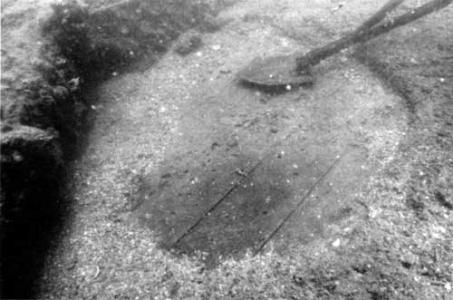
Zone 1

Aft area, about 40 percent of ship length (Stations 1 through 22). This area lies in an average depth of 8 to 10 feet. Sediment is generally 1 to 6 inches deep and is characteristically about 50 percent sand, 20 percent rubble, and 10 percent mud/silt. The sediment is held together in a spongy mat by pervading growth of colonial feather-duster worms (Branchiomma cingulata) and sponges. Large feather-duster worms (Sabellastarte sanctijosephi) inhabit the sediment in densities of about 1 to 5 per square meter. Encrusting and erect sponges are common on the sediment surface in area coverage of 1 to 10 percent.

Most substrate underlying Zone 1 sediment is teak wood. Teak is smooth and relatively dense under the thickest sediment layer. Finger-sized burrows, largely created by burrowing mollusks (primarily Martesia striata and possible Teredinid species), are evident in teak that is exposed or covered by thinner sediment cap. The color of teak in some areas is normal, whereas in other areas it has been blackened, possibly stained by exposure to sulfide compounds formed in anoxic environments under thicker sediment,

Gelatinous veneers of fish eggs (clear to purplish in color) are commonly found laid on teak and smooth metal areas that are exposed in Zone 1. Egg nests are often situated in areas that appear to have been naturally exposed by water motion, but more than 50 percent of the nest depressions have apparently been created or enhanced by fanning actions of egg-laying fish. These egg nests are likely built by the Maomao (Sargeant Major fish, Abudefduf abdominalis) that schools abundantly on the wreck. An estimated 100+ nests of 1-to-3-foot diameter were present in Zone 1 at the time of the survey.

Teak surfaces exposed in fish-egg nests exhibit considerably more mollusk-burrow damage than surfaces covered by sediment. Therefore, nesting activity should be considered as a potential chronic, deleterious process that should be monitored in future studies. Such monitoring should examine the density and seasonality of nesting activity and should compare the decomposition state of wood areas in and near nests to the control sites continuously covered by moderate sediment thickness.

Metal surfaces were encountered under sediment at only two stations in Zone 1, and that material was largely irregular texture corrosion products.

monitoring station marker
Figure 4.7B. Horizontal surface monitoring station marker in place.
(NPS photo by Larry Murphy)

Zone 2

Midships, about 25 percent of ship length (Stations 23 through 38). Depths in this area range from about 4 to 10 feet. Sediments are characterized by high rubble content (50 to 90 percent) with lesser quantities of sand and mud/silt. Coins were very common in the sediment immediately beneath the visitor viewing area of the Arizona Memorial.

Colonial tube worms and burrowing sponges are present, although in much lesser abundance than in the finer sediments of Zone 1. Erect and encrusting sponges are present at some stations. Alpheid snapping shrimps and commensal gobies are common in burrow complexes in the sediment.

The higher content of coarse material in these sediments is probably due to the presence of superstructure that provides abundant vertical substrate conducive to growth of vermetid worms and oysters. Those organisms provide shell material that comprises the bulk of the rubble. Also, the surge tends to wash finer sediments out of this shallow zone or works them into concentrated horizons in lower sediment layers.

The occurrence and thickness of mud/silt horizons under the rubble varied considerably from station to station, and where present often made viewing of the underlying ship fabric difficult or impractical because of persistent turbidity. Surfaces encountered under sediment were usually irregular corroded metal of red dish-brown or blackish coloration.

In several areas a black "tarry" hydrocarbon layer 3/4 to 2 inches thick existed over grey metal. The tarry layer is probably made up of heavier fractions of fuel oil that has settled into the lower sediment horizons over the 45-year interval since the ship's sinking. That layer appears to provide some corrosion protection to the deck steel, because most oxides observed under the layer were darker (black and grey) forms resembling "stable" oxides (magnetite and hematite). Deck surface under sediment at Station 23 was found to be porcelain tile in good condition. That area is reported to have been the ship's galley.

Zone 3

Area surrounding gun turrets No. 1 and 2, and about 25 percent of ship length (stations 39 through 50). Depths in this area are about 20 to 25 feet. Sediments are predominantly (75 to 95 percent) mud and silts with some admixed rubble and sand. These fine sediments are generally 2 to 3+ feet in thickness and contain abundant burrows of alpheid snapping shrimp and portunid crabs. Colonial feather-duster worms and sponges occur on the sediment surface in some areas but are generally rare.

Water motion in this zone is gentle and turbidity is high, indicative of an area of high sedimentation. Some of the turbidity and influx of suspended fine sediment to this area is probably caused by propeller wash from shuttle boats going to and from the Arizona Memorial dock.

Fabric underneath a 1- to 2-inch layer of "Branchiomma mat" on the top of gun No. 1 was found to be shiny steel armor plate covered by a thin black oxide coat. Surfaces under sediments at all other stations in this zone were not examined because of the extreme thickness of sediment and the turbid conditions.

Zone 4

Bow deck, 12 percent of ship length (Stations 51 through 56). Depths range from 4 to 10 feet. Sediments in this zone are similar to those found in Zones 1 and 2 (as described above) and ranged from 1 to 17 inches in thickness. Fabric under one station was found to be wood (probably teak), and corroded metal was observed under sediment at the other two stations where examination holes were dug. Water motion conditions are similar to Zone 2.


<<< PREVIOUS TABLE OF CONTENTS CONTINUE >>>


http://www.nps.gov/usar/scrs/scrs4d.htm
Last Updated: 27-Apr-2001