

Survey of Historic Sites and Buildings
 |
FORT ATKINSON (Fort Mann) Kansas |
 |
| ||
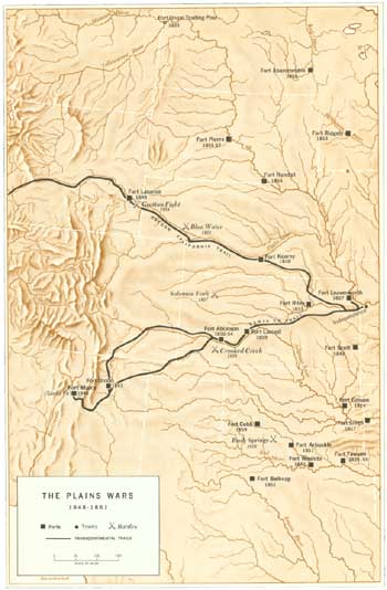
Fort Mann (ca. 1845-50), a crude adobe or log post on the north bank of the Arkansas River about 25 miles east of the Cimarron Crossing at the halfway point on the Santa Fe Trail between Fort Leavenworth and Santa Fe, served as a repair depot and rest stop for Army caravans and other freighters and travelers. The one-company post of Fort Atkinson (1850-54), constructed of sod, protected trail traffic and was in constant danger of Indian attack. At the fort on July 27, 1853, Indian Agent Thomas Fitzpatrick, representing the U.S. Government, signed with representatives of the Comanche, Kiowa, and Kiowa-Apache tribes the Fort Atkinson Treaty, comparable to the Fort Laramie Treaty (1851) with the northern Plains tribes. The southern Indians agreed to stop warring with one another and not to molest travelers on the Santa Fe Trail nor interfere with the construction of military posts and roads.
The evacuation of the fort in 1854 was a serious blow to the Santa Fe trade, and the New Mexico Territorial Legislature petitioned Congress to reestablish it. Not until 1859, however, the year Fort Larned, Kans., was founded, did another military post guard the central segment of the trail.
A large stone marker on the north side of U.S. 50, 4 miles west of Dodge City, commemorates the fort sites, on cultivated bottom land along the Arkansas River about half a mile to the southeast of the marker. No remains have survived.
 |
| The Plains Wars (1848-1861) (click on image for an enlargement in a new window) |
 |
FORT DODGE Kansas |
 |
| ||
Founded in 1865 on the Arkansas River and Santa Fe Trail about 60 miles southwest of Fort Larned and 25 miles east of the Cimarron Crossing of the trail, Fort Dodge was the most westerly in Kansas on the trail and one of its most important guardians and stopping points in the later years. The fort also protected Santa Fe Railway survey and construction crews.
During the turbulent 1860's, the bloodiest period of Indian warfare on the southern Plains, Fort Dodge was active in military operations, especially Maj. Gen. Philip H. Sheridan's winter campaign of 1868-69. Contrary to their agreements in the Medicine Lodge Treaties of 1867, the thousands of Comanches, Kiowas, Cheyennes, and Arapahos who roamed in pursuit of the buffalo over his huge command area began a reign of terror the following spring and summer from Kansas as far south as the Texas Panhandle, raiding the Santa Fe Trail and even Fort Dodge itself. Sheridan, heading the Department of the Missouri, was stymied. His troops were unable to take effective offensive action against the swift-moving bands of warriors who lived off the land. Their intimate knowledge of the geography, especially the location of water-holes, allowed them to appear from nowhere and disappear just as suddenly. When troops pursued a war party, it dispersed in all directions and reunited at a prearranged point to continue raiding.
Sheridan, desperate by the end of the summer and barraged with demands from frontiersmen to exterminate the Indians and from eastern humanitarians to soothe them, finally decided to launch an aggressive winter campaign. He knew that the warriors preferred not to fight then, when they were immobilized and vulnerable, surrounded by women and children in their camps. Sheridan notified all friendly Indians to take refuge on the reservation set apart by the Medicine Lodge Treaties and report at Fort Cobb, Okla., which he ordered reactivated. He accumulated huge stores of supplies and winter equipment at Forts Dodge, Arbuckle (Okla.), Lyon (Colo.), and Bascom (N.Mex.); and formed wagon and pack trains to transport them. He also inaugurated a rigorous training program for the troops, and recruited white and Indian scouts.
The main column proceeded southward into Indian Territory from Fort Dodge and founded Camp Supply as an advance base. There Sheridan sent Lt. Col. George A. Custer and his regiment, the 7th Cavalry, on the expedition that ended in victory at the Battle of the Washita. Two other columns, which were supposed to drive the stragglers eastward toward the main column's line of advance, moved out from Fort Bascom, N. Mex., and Fort Lyon, Colo. The Fort Bascom column won the Battle of Soldier Spring, Okla. Sheridan's campaign was very successful. It broke Indian morale and marked an innovation in Army tactics.
The 1868-69 campaign did not solve the Indian problem on the southern Plains. This occurred in the Red River War (1874-75), in which Fort Dodge was again a base. In 1872 the Santa Fe Railway had arrived in the vicinity and brought a change in economy from buffalo to cattle drives. Dodge City, the prototype of the wild and lawless cowtown, grew up in the shadow of the fort. By the end of the 1870's the frontier had moved westward from Fort Dodge with the railroad. In 1882 the Army evacuated the fort.
Numerous stone buildings, dating from 1867 and 1868, remodeled and used by the State soldiers' home that now occupies the site, stand among modern structures. They include two of the three original barracks, on the eastern side of the parade ground, which were connected in modern times; the commandant's house, in which Custer, Sheridan, and Miles may have resided, now the superintendent's residence; another unidentified structure, presently used as the administration building; the hospital, which now houses residents; a building currently used as a library that was probably the commissary; and three small cottages.
 |
FORT HARKER Kansas |
 |
| ||
Many of the Indian uprisings on the central Plains that led to General Sheridan's 1868-69 campaign erupted in the vicinity of Fort Harker (1864-73). On the north bank of the Smoky Hill River and just north of the Santa Fe Trail, the post guarded the Smoky Hill Trail to Denver and crews constructing the Kansas Pacific Railroad and was a military rendezvous point. It was the starting point and major base of Maj. Gen. Winfield S. Hancock's 1,400-man expedition of 1867 that sought to intimidate the Cheyennes and other Kansas tribes but inflamed them instead and aroused the ire of eastern humanitarians. No major engagement occurred, but the belligerent Hancock burned villages and pursued the Indians relentlessly. During the campaign, Lt. Col. George A. Custer assembled troops and replenished supplies at Fort Harker.
Kanopolis has grown up around the few stone buildings that remain at the final site, a mile east of the original location. The officers' quarters and the commanding officer's house have been modernized and are now private residences. The two-story guard house, with barred windows, is a town museum.
 |
FORT HAYS Kansas |
 |
| ||
This fort (1865-89) along the Big Creek branch of the Smoky Hill River was one of the guardians of the Smoky Hill Trail and laborers working on the Kansas Pacific Railroad. In 1867, because of flooding, it was moved from its original site 15 miles to the west on Big Creek. Indians periodically burned nearby stage stations. The fort supported General Hancock's 1867 campaign and served as General Sheridan's temporary headquarters in 1868-69. Captives taken at the Battle of the Washita, Okla., were imprisoned in a stockade next to the guardhouse. Lieutenant Colonel Custer's 7th Cavalry headquartered at the fort for several summers late in the decade and camped nearby. Adjacent Hays City, established in 1867, was a wild frontier town.
 |
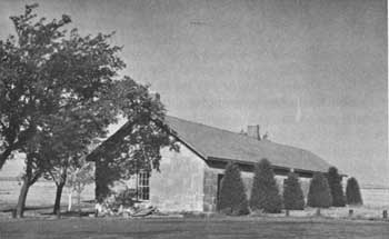
| Fort Hays guardhouse, part of Frontier Historical Park. (Kansas Historical Society) |
The remains of the fort are exhibited in Frontier Historical Park, a State historical monument administered by the State historical society. All the original buildings were of frame except for the limestone blockhouse and guardhouse. These two structures, well preserved, are the only ones that have survived at their original sites. The two-story hexagonal blockhouse houses a museum. A frame officers' quarters, moved from the fort in 1901 into Hays, where it was altered and used as a private residence, has been relocated to the fort area. The State is conducting archeological excavations at the site.
 |
FORT RILEY Kansas |
 |
| ||
Fort Riley (1853-present) has had a diverse history. Activated at the junction of the Smoky Hill and Republican forks of the Kansas River, it was one of several forts established to guard the Smoky Hill Trail to Denver. Situated between the Santa Fe and Oregon-California Trails, it also defended them. A center for protecting settlers from the Indians, it drilled troops for frontier duty and supplied other western posts. In the 1850's and 1860's it was the base of several expeditions against the Indians—as far west as Santa Fe. At the fort in 1866 Lt. Col. George A. Custer organized the newly authorized 7th Calvary Regiment. In 1891 the post became headquarters of the School of Application for Cavalry and Light Artillery, which in 1908 became the Mounted Service School and in 1919 the Cavalry School, maintained until 1946. Fort Riley today accommodates the Army General School.
An interesting early building on the Fort Riley Military Reservation, at the now extinct town of Pawnee, is the first Kansas Territorial Capitol (1855), a two-story limestone structure restored and furnished in period style; the Kansas State Historical Society administers it. Two other structures (1855) are an officers' quarters, a stone building with a frame porch, once occupied by Custer; and the post chapel, which has undergone some alteration. A large stone marker, erected in 1893, commemorates the Battle of Wounded Knee, S. Dak. (1890), the final major engagement involving 7th Cavalry troops from Fort Riley.
 |
FORT WALLACE Kansas |
 |
| ||
Commanding major Indian routes to and from Indian Territory and the reservations north of the Platte River, this fort (1865-82) was the westernmost on the Smoky Hill Trail in Kansas. Protection of the trail and construction crews of the Kansas Pacific Railroad were its prime responsibilities. Often besieged, it bore the brunt of Indian hostilities in the region in the 1860's and the 1870's. After several changes of site in the vicinity, it was finally located at the junction of Pond Creek with the south fork of the Smoky Hill River.
When Lt. Col. George A. Custer's 7th Cavalry, participating in General Hancock's 1867 campaign, arrived at Fort Wallace in July, they found the slender garrison exhausted, its supplies low, and travel over the Smoky Hill Trail at a standstill. Custer proceeded to Fort Harker for supplies and then traveled to Fort Riley, Kans., to visit his wife, which resulted in his court-martial and suspension for a year. While at Fort Wallace, Custer's men erected a stone monument in memory of 10 members of the 7th Cavalry and 3d Infantry who had died in battle. The next year, in September, Maj. George A. Forsyth and a small group of frontiersmen set out from the fort in pursuit of a group of marauding Indians. The chase culminated in the Battle of Beecher's Island, Colo.; the fort supplied the reinforcements that freed the besieged force.
The site, on private property, is on the south side of the road between it and the Smoky Hill River. Stone from the dismantled buildings is evident in others throughout the county. Some traces of structural outlines are visible, and the site is comparatively unspoiled. The military internments at the fort cemetery, across the road, have been relocated to national cemeteries. The Fort Wallace Memorial Association has restored the monument erected by Custer's men in 1867.
 |
HIGHLAND (Iowa, Sauk, and Fox) MISSION Kansas |
 |
| ||
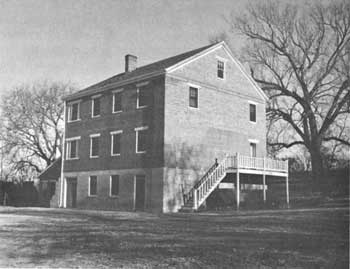
This Presbyterian mission, which relocated from northwestern Missouri in 1837 with the Iowas, Sauks, and Foxes, was founded at its new location by Rev. Samuel M. Irvin and remained in operation officially until 1866, the last 7 years under the name of the Orphan Indian Institute. The first building was a one-story log structure covered with clapboards. In 1846 workmen completed a permanent three-story building of stone and brick with 32 rooms. Until 1863, when the mission became inactive, Indian children received elementary schooling and instruction in the Iowa and English tongues, in domestic arts, manual trades, and farming. The missionaries, however, had less success in converting and domesticating their adult, nomadic charges. Progress with them was especially difficult because of outbreaks of cholera and small pox. In 1843 receipt of a printing press made possible the publication of a hymnal and grammar books in the Iowa language.
 |
| Highland Mission today. (Kansas Historical Society) |
When the mission building was sold in 1868, the west end was razed. In 1941 the State acquired the remaining portion, which had been preserved by the Northeast Kansas Historical Society, and operates it as a museum.
 |
 |
http://www.cr.nps.gov/history/online_books/soldier-brave/sitec5.htm
Last Updated: 19-Aug-2005