

Survey of Historic Sites and Buildings
 |
CAMP LYON Idaho |
 |
| ||
This crude post near the Oregon-Idaho boundary was active only from 1865 until 1869. In January 1867 its troops, serving in General Crook's drive against the Snakes (1866-68), accompanied him on a scout along the Owyhee River that culminated in a victory at Steens Mountain. The garrison also protected miners, settlers, travelers, and stages on the Ruby City-Owyhee Crossing Road.
The site, marked by a sign, is privately owned. No remains of the eight or so log-walled huts, roofed with dirt-covered poles, that made up the fort are extant. The cabin atop the hill over looking the site and other ranch buildings, however, may incorporate some of the fort's lumber.
 |
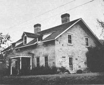
| Commanding officer's quarters, Fort Boise, as it appears today. (National Park Service) |
 |
FORT BOISE (Boise Barracks) Idaho |
 |
| ||
Known after 1879 as Boise Barracks, this post was founded by Oregon and Washington Volunteers in 1863 along the Oregon Trail in the Boise River Valley to guard the trail, protect miners, and aid law enforcement in the mining camps. Beginning in 1860 thousands of prospectors, ignoring warnings of Indian massacres, swarmed into Idaho and eastern Oregon. Infuriated, the Northern Paiutes (Snakes) of the Snake River region preyed on stage coaches, wagon trains, miners, and ranchers. Civil War Volunteers could not quell them, and negotiations to place them on reservations ended in failure. The progress of the Regulars who inherited the difficult task at the end of the war was not sufficient to quiet the public uproar. In December 1866 a new district commander, Gen. George Crook, arrived at Fort Boise. Immediately tightening discipline and bolstering morale, he organized a group of Indian scouts, moved promptly into the field, and launched a hard-hitting campaign (1866-68). It crushed the Snakes, perfected his combat techniques, and helped propel him to the fore of the Indian-fighting generals.
Centrally located as it was, Fort Boise also participated in other northwest campaigns. Its garrison bore the brunt of the Bannock War (1878), fought in Idaho and eastern Oregon against the Bannocks who had fled westward from the Fort Hall Reservation, Idaho, and their newly recruited Paiute, Umatilla, and Cayuse allies. In July Gen. Oliver O. Howard defeated them at Birch Creek, Oreg., and returned them to the reservation.
In 1919, some 6 years after its inactivation, the post passed into the hands of the Public Health Service; and in 1938 to the Veterans' Administration. Today a city park occupies part of the site. Several 19th-century buildings, a few considerably altered and most of them used by the Veterans' Administration, are still standing. The oldest (1863) is one of a group of officers' quarters; the rest date from the 1890's. Other structures are a paymaster's office (1864) and an unidentified building (1870).
 |
FORT HALL [U.S. Army Post] Idaho |
 |
| ||
This fort was established in 1870 between the Snake and Portneuf Rivers about 25 miles northeast of its namesake, the old fur trading post, to control and protect the Shoshonis and Bannocks who resided on the Fort Hall Indian Reservation, founded 3 years before. The Bannocks, angered by the invasion of settlers, chafing at restriction to the reservation, and resenting the inadequacy of food and other annuities, began plundering white settlements and ranches and set off the Bannock War (1878). Fort Boise, Idaho, however, conducted the principal military operations against them and the allies they acquired as they fled westward in Idaho and into Oregon. Fort Hall remained active until 1883, by which time the area was more densely populated and the completion of a railroad through the region made it possible to bring any needed troops northward from Fort Douglas, Utah. The Indian Bureau took over the military reservation.
The site is located along Lincoln Creek on the Fort Hall Indian Reservation. No remains have survived of the log and frame post.
 |
 |
http://www.cr.nps.gov/history/online_books/soldier-brave/sitec4.htm
Last Updated: 19-Aug-2005