


Survey of Historic Sites and Buildings
 |
BIG BEND NATIONAL PARK Texas |
 |
| ||
Stretching along the United States-Mexico border in the cradle of the Big Bend of the Rio Grande, this giant park presents a panorama of rugged and spectacular river, mountain, canyon, and desert scenery; unusual geological features; and unique plant and wildlife. The magnificent Chisos Mountains soar 4,000 feet above the desert floor in the center of the park. Although primarily significant for its natural and scenic qualities, the park has associations with the phases of history treated in this volume.
The majority of early Spanish soldiers, explorers, and missionaries who passed through the region skirted the park area, whose brooding canyons were hospitable only to scattered Indian bands. A particular scourge to the Spanish and Mexican (after 1821) frontiers were the nomadic Comanches, some of whom frequented the Big Bend region, especially the Chisos Mountains. Early adopting the Spanish-introduced horse, they swept down from their home in the Oklahoma-Texas Panhandles over the Great Comanche War Trail, which passed through the park, and spread devastation as far south as Durango, Mexico. To counter these raids, the Spaniards founded a series of presidios. One of these, maintained in the 1780's and 1790's, was the Presidio of San Vicente, established across the Rio Grande from today's park in Mexico to guard a key ford.
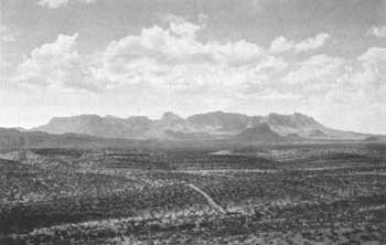 |
| The Chisos Mountains of Big Bend National Park. (photo George Grant, National Park Service) |
In 1845 the United States annexed Texas, which 9 years earlier had won its freedom from Mexico. By the outbreak of the Civil War, Texas Rangers and U.S. troops had begun the difficult task of pacifying the Indians of western Texas. During the period of Confederate occupation of Fort Davis, Chief Nicolas' band of Southern Mescaleros, who had been raiding the San Antonio-El Paso Road, killed two herders while rustling cattle at the fort. In the Big Bend country, within the present park, the Indians annihilated Lt. Reuben E. Mays' pursuing detachment of 14 men. Only one Mexican scout survived. After the war, in 1871, Lt. Col. William R. Shafter, Fort Davis commander, led a small expedition into the Big Bend region to intimidate the Apaches lurking there. Meeting none but finding abundant evidence of their presence, he demonstrated to the Indians that the mountains of the Big Bend were no longer a haven.
Many of the Indians, feeling the pressure of white settlements and often being divided by factional quarrels, resisted Army attempts to force them onto reservations. Seeking refuge in the Big Bend area or pausing there on raids, they readily slipped into Mexico when the intensity of the pursuit mounted. The Army's post-Civil War drive against them culminated in the 1880's. The death of the Apache Chief Alsate in his Chisos stronghold in 1882 marked the end of Indian troubles in the Big Bend region. During the decade, railroads and large numbers of cattlemen penetrated the trans-Pecos region and inaugurated the modern era.
The array of park interpretive services—such as self-guiding trails, marked drives, roadside exhibits, evening campfire talks, and guided hikes—emphasize the park's geology, prehistory, and plant and wildlife but include a coverage of the history. All extant historical structures in the park pertain to themes outside the scope of this volume: the growth of ranching, farming, and mining in the area; and diplomatic, economic, and military relations with Mexico in the 20th century.
 |
 |
http://www.cr.nps.gov/history/online_books/soldier-brave/sitea22.htm
Last Updated: 19-Aug-2005