PU'UHONUA O HONAUNAU NHP
A Cultural History of Three Traditional Hawaiian Sites
on the West Coast of Hawai'i Island

|
PU'UKOHOLA HEIAU NHS • KALOKO-HONOKOHAU NHP • PU'UHONUA O HONAUNAU NHP A Cultural History of Three Traditional Hawaiian Sites on the West Coast of Hawai'i Island |
|
|
Site Histories, Resource Descriptions, and Management Recommendations |
CHAPTER VII:
PU'UKOHOLA HEIAU NATIONAL HISTORIC SITE (continued)
J. John Young Homestead (continued)
3. Pahukanilua
a) Boundaries
Little information on Young's homestead has been found, with only a few references in his unpublished diary and in the writings of foreign visitors. Other data comes from boundary commission reports of the kingdom and archeological survey work.
According to Menzies, by 1793 both Young and Davis had received plantations from Kamehameha on which they were raising hogs and vegetables. [170] Pahukanilua, fronting Kawaihae Bay a short distance north of Pelekane, comprised the sacred residential area of the high chief John Young and his family, just as the latter was the site of the sacred enclosure of the Kamehameha family. [171] Young's homestead there historically included two portions: a lower one that lies outside the present park boundary and is covered with dredged coral fill from harbor construction activities and an upper one, owned by the National Park Service, containing the ruins of his last permanent home. [172]
b) Lower Portion
Land Commission Award testimonies in connection with the Mahele in 1848 indicate that Young lived on the lower portion of his homestead in 1795, evidently moving higher up the slope within the next few years. [173] Young's second wife, Ka'oana'eha, continued to live in a Hawaiian-style house, although its precise location is uncertain. As will be discussed later, some structures built in the traditional style were constructed around Young's house on the upper portion of his homestead, but whether his wife moved up there or continued to live in the beach area is unclear. This author favors the latter theory, both because she tended to follow traditional Hawaiian customs and lifestyles and on the basis of the 1828 description by Mrs. Judd that follows.
A local informant, William Akau, stated that his great-grandmother told him that a building near the beach in which he had played as a child had been the house of Queen Emma, the high chiefess Emma Rooke, granddaughter of John Young through his daughter Fanny. The house was located on the current site of a coral crushing operation, its foundation having been buried when the reef was dredged and the coral stockpiled. According to Akau, this was a two-story building, about seventy-five by fifty feet, with steps inside leading to an upper story. Its foundations were of stone, mud, and grass. Kelly theorizes this may have been the ruins of Young's old house in which the missionary wife Laura Judd stayed. Its location corresponds to the site Jackson designated on his 1883 map as "John Young's old house." Its connection with Queen Emma is uncertain, although according to Apple, Emma collected rent for a house in the lower portion of Pahukanilua in 1861. [174]
Queen Emma's mother, Fanny Kekela Naea, owned a residence at Lahaina, Maui, but also maintained one at Pahukanilua, shown as "Fanny Young's HS" on the A.B. Loebenstein 1903 map of Kawaihae. Tradition holds that Queen Emma was born at Kawaihae — a Ca. 1889 photograph of the beach area at Pahukanilua (Illustration 63) shows a grass-thatched house identified as that in which Queen Emma was born. Could this have been Ka'oana'eha's native-style house, and perhaps the earliest home of the Youngs? The structure appears in another picture (Illustration 43) that shows its position relative to Pu'ukohola Heiau. Apple notes testimony presented in 1848 during application for a Land Commission Award that mentions five houses and planted areas in Pehukanilua, on property originally belonging to Olohana (John Young), that now belonged to Ka'oana'eha and her companion Puna. [175] Structures historically in the Young enclosure in Pahukanilua were gone by the 1950s when harbor dredging operations took place. [176]
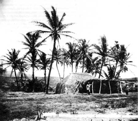 |
| Illustration 63. Kawaihae grass house often referred to as Queen Emma's birthplace. Photo attributed to W. T. Brigham, 1889. Courtesy Hawaii State Archive, Honolulu. |
c) Upper Portion
(1) Early Maps of Homestead
The earliest map identifying the site of John Young's house is that of L. l. Duperrey, made in 1819, which shows a "Maison de Young" on the first set of ridges overlooking Kawaihae and the bay, some distance north of Pu'ukohola Heiau. The 1883 George Jackson map delineates in better detail a "ruin, Young's house," above Makahuna Gulch, and "John Young's old house" at the foot of Makahuna Gulch.
(2) Young's Accounts of Construction Activities
Young's diary records the construction of permanent structures on the upper portion of his property beginning in 1798 with the importation of coral blocks from nearby reefs that were burnt and mixed with sand, poi, and animal hair to form mortar and plaster. Young describes constructing three Western-type buildings on this bluff: his residence, a cookhouse and storage room, and a house for the children and their guardians. He also constructed a storage house "near the small temple" (Mailekini Heiau?). He noted that this higher location was more suitable than the lower elevation, which had been subject to flooding from a ravine, possibly Makeahua Gulch. [177]
Young recorded in March 1799 that he had plastered all the houses and whitewashed fences around his animal pens. A mention of leaks in that year might suggest that his mortared and plastered buildings were covered with thatched roofs. His diary notes only a few other improvements, such as another cookhouse built in 1809 and a shelter or lanai evidently attached to one of the houses in approximately 1817. [178]
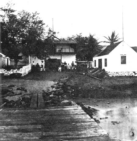 |
| Illustration 64. Kawaihae landing, showing two-story adobe structure. Photo attributed to A.A. Montano, ca. 1882 (Monsarrat Collection). Courtesy Hawaii State Archives, Honolulu. |
(3) Description by Isaac Iselin, 1807
Young entertained Isaac Iselin, supercargo on the Maryland, and some companions at his home in 1807, Iselin noting that "Mr. Young occupies several stone buildings, which are the best (save those of the king, built on the same plan but now shut) I have seen in this island." [179] Alexander Ross, clerk on the Ton quin, during a stop at the islands in 1811, recalled that Governor John Young,
received us kindly, and with every mark of attention peculiar to an Indian Chief; showed us his wife, his daughter, his household, and his vassals — a strange assemblage of wealth and poverty, filth and plenty. . . . He is now about sixty years of age, shrewd and healthy . . . but more Indian than white man. [180]
(4) Descriptions by Crew of Rurick, 1816
Naturalist Adelbert Chamisso aboard the Rurick stated about 1816 that "From out at sea, we could see the European built houses of John Young towering above the grass shacks of the natives." [181] Otto von Kotzebue, commander of the ship, from Kawaihae Bay noticed the barren appearance of the land but noted an oasis of sorts, "Young's settlement of several houses built of white stone, after the European fashion, surrounded by palm and banana trees. . . ." [182] De Freycinet, who visited an aging and ill John Young in 1819 and discussed with him Liholiho's political difficulties following the death of his father, found him in his house
at the top of a small hill that overlooks the village of Kohaihai. It was built of stone and was well ventilated and sanitary.
. . . . . . . . . .
this family, thanks to Tamehameha's good graces, lives here in plenty: they possess several stone houses and considerable land on Owhyhi as well as on the other islands. [183]
(5) Description by Arago, 1819
Jacques Arago adds further information:
The house of Mr. Young is unquestionably the most considerable, or rather the only passable one at Toyai. It is situated on an eminence, whence the prospect extends to a great distance over the sea, and towards the interior of the island. . . . On a hill opposite to that on which the house of Mr. Young is built, there is a very large morai [Pu'ukohola Heiau]. ..... [184]
(6) Description by Laura Judd, 1828
Although most visitors viewed Young's small complex as far superior to the nearby native huts, as least one visitor preferred the latter. Laura Fish Judd, wife of Dr. Gerrit P. Judd, who arrived in Honolulu in 1828 with the third missionary company, was among several of this group entertained by John Young at his Kawaihae home:
He [Young] had married a native woman of rank, has a fine family of sons and daughters, and is considered a chief. He lived in a dirty adobe house, adorned with old rusty muskets, swords, bayonets, and cartridge boxes. He gave us a supper of goat's meat and fried taro, served on old pewter plates, which I was unfortunate to see his servant wipe on his red flannel shirt in lieu of a napkin. . . . We were sent up a rickety flight of stairs to sleep. I was afraid, and requested Dr. Judd to look around the room carefully for concealed dangers. . . . Sleep was out of the question; I was afraid of the wind . . . and got up at midnight, and went down to the grass house of Mrs. Young, which was neat and comfortable... . She lives in native style. . . [185]
 |
 |
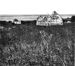
| Illustration 65. Left half of stereoscopic ambrotype identified as "first house of stone built by John Young during time of Kamehameha I in Kawaihae." Photo by A.A. Montano, ca. 1882 (Monsarrat Collection). Courtesy Hawaii State Archives, Honolulu. | Illustration 66. Right half of stereoscopic ambrotype identified as John Young's Kawaihae residence. Photo by A.A. Montano, ca. 1882 (Monsarrat Collection). Courtesy Hawaii State Archives, Honolulu. |
(7) Missionary Descriptions
The Reverend Lorenzo Lyons stayed with Young on his way to man the mission station at Waimea. He and his companions "took lodging in a native house with Mr. Young . . ." [186] Which structure he is referring to is uncertain. Either of Young's stone houses would have been more substantial than the common "native" style. In a later (1871) published reminiscence of this trip to Waimea, Lyons recalled that "The grayheaded old man, Mr. Young, received us kindly into his stone house with thatched roof. The house still stands but in dilapidated state and unoccupied." [187] Sereno Bishop, visiting the Lyonses at Waimea in 1836, stated that he had enjoyed the hospitality of the "aged" Mr. Young at Kawaihae, although this visit must actually have taken place at the end of the previous year, shortly before Young's death. Bishop recalled that
A coffin was suspended under the ridge of the house. It was the old chief's [Young's] habit, whenever he went to Honolulu, to provide himself with a new coffin, in order to be so far in readiness for the change which was approaching. I trust that he was otherwise not unprepared. [188]
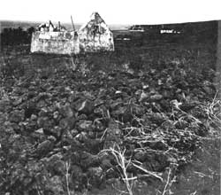
Illustration 65 is purportedly a picture of the Young homestead. If so, the structure seen near the beach below it might be either his old house as shown on the 1883 map or the ruins of the Reverend Lyons's home. The other view of the ruins (Illustration 66) shows the Kawaihae Church in the background to the right. [189] Illustration 67 is supposedly a picture of the house ruins ca. 1920.
(8) Use of the Homestead After Young's Death
In 1853 George Washington Bates visited Kawaihae and noted that Young's house was still standing and tenanted by a district judge, a former teacher at the Oahu Charity-School. [190] It is probable that this house was not utilized immediately after Young's death, its furnishings being distributed among family members and the structure closed. In fact, Apple surmises that the entire upper portion of the homestead was probably abandoned in 1835. Under a program of Land Commission Awards that lasted from 1846 to 1855, certain small pieces of land within ahupua'a such as house lots and garden plots were given formal boundaries and awarded to their tenants.
The still-occupied lower portion of the John Young homestead was awarded in this way, making its ownership not only legally distinct from the ahupua'a of Kawaihae Hikina surrounding it, but separating it completely from the abandoned upper portion of the homestead. [191]
The early maps show a lot for a church between the upper and lower portions of the Young homestead. It is believed this was the location of a church/school building from about 1834 to 1859, a location that would have required Young's approval as resident chief and possessor of the land. The earliest grass church there was replaced in 1843 with a larger stone-walled structure. The last Congregational church in Kawaihae was built in 1858 in a different location, on a hill farther north overlooking the bay and was razed in 1959. [192] William Akau's great-grandmother told him that the ruins known today as those of John Young's house were once a Catholic school. Kelly suggests a Catholic school might have occupied the upper homestead structures after Young's death, when a pro-Catholic governor of Hawai'i Island, Kuakini, was in power. [193] Apple found no evidence of a Catholic presence at Kawaihae or specifically in this area, although John Young II might have permitted a Catholic school in the vacant Young homestead structure. [194] Perhaps this question is related to the tenancy of the house by the former schoolteacher whom Bates noted in 1853.
The only other structure shown on maps of this area during Young's time period is the house of the Reverend Lorenzo Lyons, used when he visted Kawaihae to preach or to catch a boat to leave the island. Young must also have authorized his residence. [195] A fishpond existed in the Pahukanilua area from about 1819 through 1848, fed by the fresh waters of Makeahua Gulch, with access to salt water and fish via a sluice grate. This would have been of the loko wai type, producing mullet and milkfish. [196] (See Duperrey 1819 chart, Illustration 27.)
Upon the death of John Young, the crown confirmed the retention of Young's lands by his heirs. Apple points out that "This was royal recognition as early as 1834 that certain people and families had gained some interests and rights in lands assigned them for service to the crowns of the Kamehameha dynasty." [197] From 1835, the year Young died, until her death in 1850, Young's wife remained resident chiefess of Kawaihae 2, probably continuing to reside on the lower portion of the homestead where she had lived since her marriage. Title then passed to John Young, Jr., who left it to his niece, Queen Emma. At her death in 1885, the ahupua'a passed to the trustees of the Queen's Hospital (now Queen's Medical Center). They, in turn, donated acreage to the National Park Service to enable establishment of Pu'ukohola Heiau National Historic Site. [198]
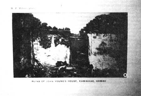 |
| Illustration 67. Ruins said to be those of John Young's house, ca. 1920. Photo by W.F. Wilson in Macrae, With Lord Byron at the Sandwich Islands, facing p. 48. |
| <<< Previous | <<< Contents >>> | Next >>> |