| ||
 | ||
 | ||
 | ||
 | ||
 | ||
 | ||
 | ||
 | ||
 | ||
 | ||
 | ||
 | ||
 | ||
 | ||
 | ||
 |
 |
 |
Vicksburg National Military Park Tour Roads
Vicksburg, Mississippi
CREATING A COMMEMORATIVE ROADWAY
The roadway proposed for Vicksburg National Military Park (VNMP) was intended to provide access to the most historically interesting areas of the battlefield. Park commissioners were dedicated to the idea that the road system should be geared toward the average citizen, visiting for a day. Resident Commissioner William T. Rigby insisted that the roadway make a loop, because it was thought that otherwise visitors would be forced to waste valuable time traveling to the various points of interest and would face the inconvenience of non-park traffic on non-park roads. The commissioners and engineers involved with routing the roads planned to create a continuous park roadway, which would allow visitors to view the historic landscape without leaving their wagons or carriages.
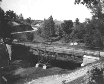
Steel viaduct spanning Glass Bayou on Union Avenue. Constructed ca. 1903, later destroyed during rerouting of the tour roads. (WICK) |
In designing the road system at Vicksburg, engineers sought to protect and preserve the historic landscape. This involved building roads along the lines that existed during the battle and following the natural contours of the ground as closely as possible to avoid the false appearance of any shelter or defense for troops behind a raised road or in a sunken road.
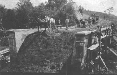
Roadway and Melan arch bridge under construction along Union Avenue. ca. 1903. Horse-drawn equipment was used to grade the roadbed. (VICK) |
In 1900, the VNMP commissioners decided that construction of the interior park roadway should be the first project in the development of the park's road system. The interior road, along the Confederate side of the park, was chosen as a starting point because the Confederate line of defense remained constant throughout the siege. Composed of a series of redoubts, redans, and lunettes all connected by a continuous line of trenches and rifle-pits, the definite nature of this line made it relatively easy to determine the location of the interior roadway. On the Union side of the park, the fluctuations of the Federal line as troops advanced made the location of the exterior roadway much more difficult and time consuming. Construction on this exterior roadway was postponed until 1903.
| Introduction | Acadia | Blue Ridge Parkway | Colonial Parkway | Generals Highway | George Washington Memorial Parkway | Great Smoky Mountains | Mount Rainier | Rock Creek and Potomac Parkway | Shenandoah's Skyline Drive | Southwest Circle Tour | Vicksburg | Yellowstone | Yosemite | Discover History |