| ||
 | ||
 | ||
 | ||
 | ||
 | ||
 | ||
 | ||
 | ||
 | ||
 | ||
 | ||
 | ||
 | ||
 | ||
 | ||
 |
 |
 |
Southwest Circle Tour Roads and Bridges
Zion, Bryce, Grand Canyon North Rim National Parks
Cedar Breaks, Pipe Spring National Monuments
Kaibab, Dixie National Forests
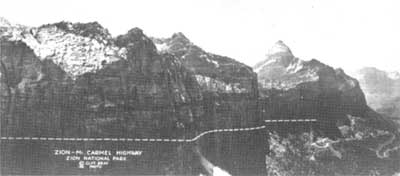
The surveyed route of Zion-Mount Carmel Highway, here superimposed on photographs, challenged BPR engineers. ZNP. |
COMPLETING THE CIRCLE
In 1925, the Utah Road Commission continued its federal aid projects with new roads from Cedar City south to Toquerville (Highway 91) and from Kanab north toward Bryce Canyon (U.S. Highway 89). The southern segment remained the circle's weak link to regional tourism. The same year, Utah state crews completed the "Rockville Shortcut," which spanned the Virgin River with a $40,000 steel truss bridge built by the NPS in 1924, and continued around Smithsonian Butte toward Pipe Spring. This bridge and road—today a Bureau of Land Management "scenic backway"—shortened the drive to Pipe Spring by 30 miles. Nonetheless, engineers of the Bureau of Public Roads and Utah Road Commission were already planning a new road to run directly east from Zion National Park and shorten distances to Bryce and the Grand Canyon's North Rim.
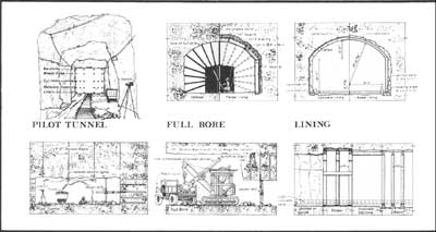
This drawing illustrates the stages of tunnel construction employed on the Zion-Mount Carmel Highway Tunnel from 1927-30. Laura J. Culberson, HAER, 1993. |
| Introduction | Acadia | Blue Ridge Parkway | Colonial Parkway | Generals Highway | George Washington Memorial Parkway | Great Smoky Mountains | Mount Rainier | Rock Creek and Potomac Parkway | Shenandoah's Skyline Drive | Southwest Circle Tour | Vicksburg | Yellowstone | Yosemite | Discover History |