| ||
 | ||
 | ||
 | ||
 | ||
 | ||
 | ||
 | ||
 | ||
 | ||
 | ||
 | ||
 | ||
 | ||
 | ||
 | ||
 |
 |
 |
Southwest Circle Tour Roads and Bridges
Zion, Bryce, Grand Canyon North Rim National Parks
Cedar Breaks, Pipe Spring National Monuments
Kaibab, Dixie National Forests
MORMON SETTLERS TO SOUTHWESTERN UTAH
Soon after Brigham Young led members of the Church of Jesus Christ of Latter Day Saints (Mormons) west from Illinois to the Great Salt Lake in 1847, he sent explorers south to find additional settlement sites. These pioneers followed the Old Spanish Trail as far as present-day Cedar City, then struck south in the footsteps of Dominguez, Escalante, and Smith to reconnoiter the Virgin River and its tributaries, By 1863, dozens of small Mormon agricultural towns had sprouted along the river and streams, from Paragonah and Cedar City on the north to St. George on the south and Zion Canyon on the east. Nephi Johnson, a young pioneer, was among the early scouts and the first to set foot in Zion Canyon in 1858. Four years later, Isaac Behunin and others founded the small settlement of Zion within the canyon near the site of today's lodge.
Soon after these pioneers colonized the Virgin River area, others crossed the Markagunt Plateau from Paragonah to the later town of Panguitch, then headed south along the Sevier and East Fork Virgin rivers as far as Fredonia, Arizona. The many white settlements established along this path and elsewhere in the region— having overcome periodic floods, pestilence, disease and efforts by the Navajo, Utes and Southern Paiutes to retain their lands—went on to construct roads and paths linking the isolated communities.
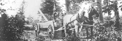
Mormon pioneers travelled the rugged terrain with horse-drawn wagons Several primitive roads existed in southwestern Utah, such as this one used to haul lumber to the Zion cable works, an aerial conveyor to the Valley, ca. 1908. Zion Natural History Association (ZNHA). |
CONNECTING THE DOTS WITH WAGON ROADS
Nearly all the highways that connect Zion, Pipe Spring, the North Rim of the Grand Canyon, Bryce, and Cedar Breaks began as rough wagon roads between the early Mormon towns.
West of Zion, Interstate 15 follows the path of an early wagon road connecting Cedar City to Kanarraville, Pintura, Leeds, Washington, and St. George. The most difficult portion of this route passed over the "Black Ridge" at the southern edge of the Great Basin, a few miles north of Pintura. Here, at a point called Peter's Leap, Mormon teamsters dismantled their wagons and lowered them by ropes to the basin floor. In 1863, townspeople built the Black Ridge Dugway down the ridge, permitting wagons to roll (in one piece) south from Salt Lake City to St. George. Today, motorists can view portions of this road within the canyon to the east of Interstate 15.
East of Zion, U.S. Highway 89 from Kanab north to Panguitch follows the wagon trails linking these towns—and Mount Carmel, Orderville, and Glendale in between—with Salt Lake City. The road immediately north of Kanab crossed some of the most rugged terrain in southwestern Utah, where quicksand, steep slopes, and sand dunes hampered travellers well into the 1900s.
As difficult as these north-south roads were to travel, connecting east-west roads posed even greater challenges as they had to surmount intervening plateaus and deserts. An early road developed south of Zion along today's Utah Highway 59 and Arizona Highway 389 beneath the Vermillion Cliffs. Following established Paiute trails, Mormon trailblazer Jacob Hamblin formalized this route east and west from Pipe Spring, which he found in 1858. By 1870, the wagon road linked St. George to Colorado City, Pipe Spring, and Kanab, then ran east parallel to today's U.S. Highway 89 to the Colorado River. A variation of this trail dropped south around the Kaibab Plateau and paralleled today's U.S. 89A to cross the Colorado River at Lee's Ferry.
North of Zion, Mormon explorer John D. Lee and others pioneered a trail across the Markagunt Plateau to the site of Panguitch. This path developed into a wagon road used throughout the nineteenth century, but later roads in the same area ran farther south. By 1925, the final grade of the northern connection lay along today's Utah Highway 14 from Cedar City to Long Valley Junction.
| Introduction | Acadia | Blue Ridge Parkway | Colonial Parkway | Generals Highway | George Washington Memorial Parkway | Great Smoky Mountains | Mount Rainier | Rock Creek and Potomac Parkway | Shenandoah's Skyline Drive | Southwest Circle Tour | Vicksburg | Yellowstone | Yosemite | Discover History |