| ||
 | ||
 | ||
 | ||
 | ||
 | ||
 | ||
 | ||
 | ||
 | ||
 | ||
 | ||
 | ||
 | ||
 | ||
 | ||
 |
 |
 |
Southwest Circle Tour Roads and Bridges
Zion, Bryce, Grand Canyon North Rim National Parks
Cedar Breaks, Pipe Spring National Monuments
Kaibab, Dixie National Forests
HIGHWAYS AND THE LANDSCAPE
Since its creation in 1916, the National Park Service (NPS) has adhered to a policy that structures in the national parks and monuments "lie lightly on the land." Stephen Mather, the agency's first director, established the NPS landscape engineering division in 1918. Since that year, landscape engineers have reviewed plans and specifications for all major building projects.
Today's park roads also benefit from the engineering expertise and aesthetic sensitivity of the Bureau of Public Roads. The U.S. Department of Agriculture created the BPR (then known as the Office of Road Inquirty) in 1893 to lead th eway in modern road-building technology. Since 1925, it has managed all major road projects for the Park Service, and continues that service today as the Federal Highway Administration.
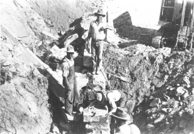
Construction crews, ca. 1930, hand place sandstone blocks for retaining walls that carry Zion-Mt. Carmel Highway up the talus slopes of Pine Creek Canyon toward the Zion Tunnel. ZNP. |
The NPS/BRP team undertook the Zion-Mt. Carmel Highway in Zion National Park as one of its first road projects. As you drive the road today, note the many ways the highway blends with the enviornment. The roadway is chip-sealed with red-tinted gravel, chosen to match the surrounding sandstone cliffs. The masonry arch of Pine Creek Bridge mimics the Great Arch of Zion viewed upstream. Masonry retaining walls and guardrails, many of which were built by the Civilian Conservation Corps in the 1930s, line the switchbacks carrying the road up and down the steep grades. The tunnel itself was designed to reduce destruction of the sandstone cliffs and to conceal the road as it ascends Pine Creek Canyon to the plateau above.
These and dozens of other highway design and construction techniques—road curvature, consistent grades, masonry culverts—date from a period when road building was emerging as an art form in tune with the landscape. Slow down and enjoy the vistas at every turn!
THE SOUTHWESTERN CIRCLE TOUR
Visitors to the national parks, forests, and monuments of the American Southwest generally follow a regional loop along state and federal roads. There are many variations, depending on the length of one's trip, but few cover the same ground twice. This leaflet explores the "circle tour" connecting the early parks and monuments of southwestern Utah and the Arizona Strip; Zion, Bryce Canyon, Grand Canyon North Rim, Pipe Spring, Cedar Breaks, Dixie and Kaibab national forests. Initially a series of individual roads linking pioneer towns, the southwestern circle tour achieved its final form through the efforts of the Union Pacific Railroad and the National Park Service.
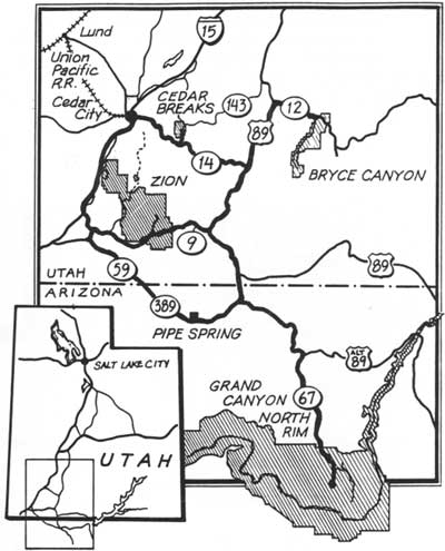
General route location of the Southwest Circle Tour. ZNP. |
| Introduction | Acadia | Blue Ridge Parkway | Colonial Parkway | Generals Highway | George Washington Memorial Parkway | Great Smoky Mountains | Mount Rainier | Rock Creek and Potomac Parkway | Shenandoah's Skyline Drive | Southwest Circle Tour | Vicksburg | Yellowstone | Yosemite | Discover History |