| ||
 | ||
 | ||
 | ||
 | ||
 | ||
 | ||
 | ||
 | ||
 | ||
 | ||
 | ||
 | ||
 | ||
 | ||
 | ||
 |
 |
 |
Great Smoky Mountains National Park
North Carolina, Tennessee
PRE-PARK TRANSPORTATION SYTEMS
The motor roads of GRSM did not simply materialize with the establishment of the park in 1934. Long before tourists began motoring over Newfound Gap and causing traffic jams in Cades Cove, American Indians, European settlers and logging companies created sophisticated transportation networks throughout the mountains that would greatly influence the future motor roads of GRSM.
Early on, Indians blazed an intricate system of footpaths across the Great Smokies. This process continued when the Cherokee, a branch of the Iroquois nation, migrated to the region more than one thousand years ago from the upper Ohio River. To link their two principal trails running parallel to one another on either side of the Smokies, the Cherokee cut three footpaths directly across the mountains. The Cataloochee Trail, the Tuckaleechee-and-Southeastern Trail, and the Indian Gap Trail were each used for hunting, for socializing with kinfolk, and, on some occasions, for making war. All three footpaths also laid the foundation for future park roads including the. Cataloochee Valley Road, the Laurel Creek Road near Cades Cove, and Newfound Gap Road.
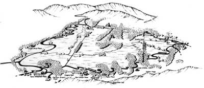
Drawing illustrating present day road system in Cades Cove. |
As did their predecessors, early white settlers also traveled extensively throughout the mountains. Those settling during the 1820s and 1830s in Cataloochee and Cades Cove first widened the Cherokee footpaths they had followed into the region. Soon they also began constructing new wagon roads throughout the Smokies so they could visit with neighbors, attend school and religious services, and transport herds of cattle and wagon-loads of produce to distant markets in Maryville, Knoxville, and beyond. The present-day road system in the Cades Cove area dates from this era.
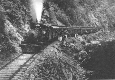
Locomotive No. 148 steams up the Little River Gorge. ca. 1909-1914. The present Little River Road was constructed over this right of way in 1932. (GRSM/Joe Murphy, Jr.) |
Unlike early settlers, loggers sought out the more inaccessible land within the Smokies. Here, where no farmer had cleared, sown or harvested, they found one of the greatest virgin deciduous forests on earth. Timber firms such as the Little River Lumber Company began cutting in 1901 and by the mid 1930s had logged approximately 85 percent of what would become the national park. To transport this timber from forest to mill, timber companies relied on an elaborate system of logging railroads, some of which eventually became park motor roads. The Little River Road on the Tennessee side of the park and the Balsam Mountain-Heintooga Road in North Carolina were both constructed atop old railroad beds.
| Introduction | Acadia | Blue Ridge Parkway | Colonial Parkway | Generals Highway | George Washington Memorial Parkway | Great Smoky Mountains | Mount Rainier | Rock Creek and Potomac Parkway | Shenandoah's Skyline Drive | Southwest Circle Tour | Vicksburg | Yellowstone | Yosemite | Discover History |